Earthquake emergency rescue-oriented arthquake population thermodynamic diagram calculation method

A technology of emergency rescue and calculation method, applied in the direction of calculation, geographic information database, special data processing applications, etc., can solve the problem of insufficient accuracy, limited positioning accuracy, communication network density and coverage, whether terminal functions are enabled and data sampling rate, Unable to meet the requirements of earthquake emergency rescue and other issues, to achieve effective research and judgment support, high time resolution and spatial resolution, and good time precision

Pending Publication Date: 2021-07-20
湖北省地震局
View PDF12 Cites 1 Cited by
  • Summary
  • Abstract
  • Description
  • Claims
  • Application Information

AI Technical Summary

Problems solved by technology

Traditional earthquake emergency population statistics methods mainly rely on household registration statistics and ground manual surveys, which cannot meet the timeliness requirements of disaster relief decisions during the black-box period of earthquakes
Moreover, with the rapid economic development in recent years and the increase in population mobility, there may be a large discrepancy between the actual population in the earthquake area and the household registration statistics.
With the rapid development of technologies such as mobile communication, spatial positio

Method used


Image

  • Earthquake emergency rescue-oriented arthquake population thermodynamic diagram calculation method
  • Earthquake emergency rescue-oriented arthquake population thermodynamic diagram calculation method
  • Earthquake emergency rescue-oriented arthquake population thermodynamic diagram calculation method

Examples


Example Embodiment

[0047] Example 1

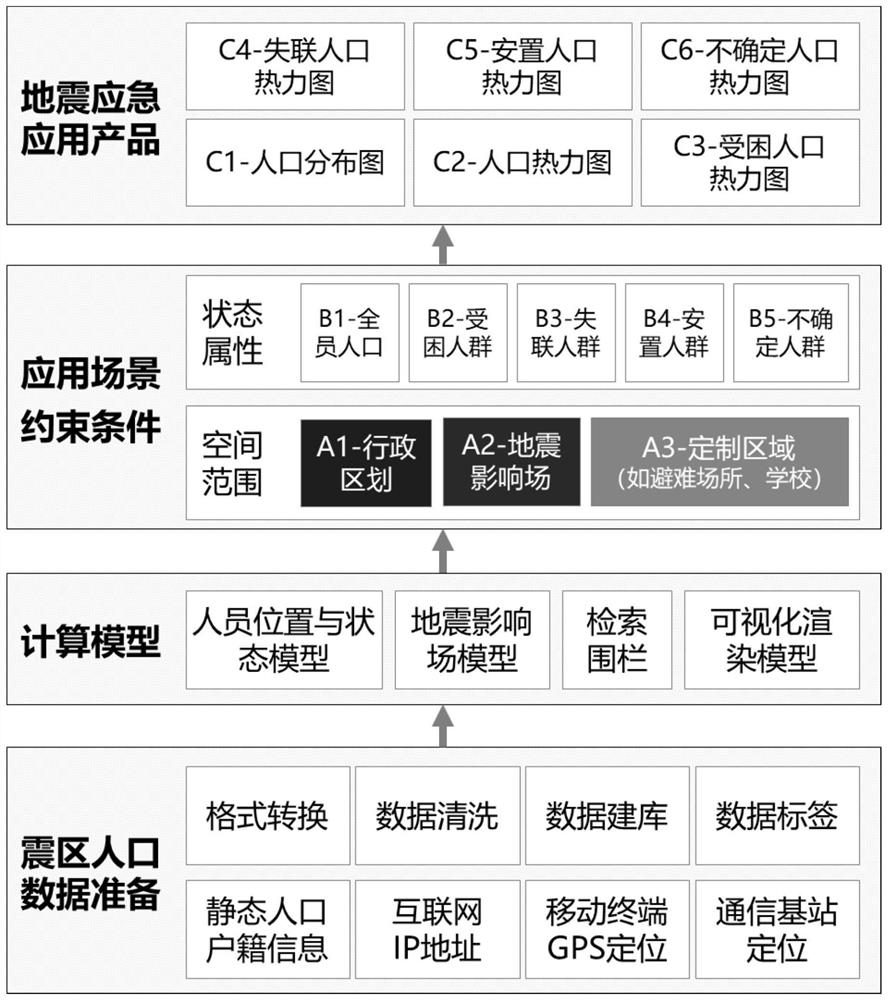
[0048] When an earthquake occurs, obtaining personnel location information is the most critical information in implementing rescue work. Although the real IP address of the Internet can be used to locate the user's geographic location, its positioning accuracy is limited by the density and coverage of the communication network, whether the terminal function is enabled, and the data sampling rate. For example, under normal circumstances, Internet IP address acquisition is not updated in real time, but is updated at a certain time interval, such as once an hour. It is far from enough to meet the requirements of earthquake emergency rescue. Therefore, in order to solve the above problems, such as figure 1 As shown, this embodiment provides a method for calculating an earthquake population heat map for earthquake emergency rescue, including the following steps:

[0049] S1. Based on the calculation model of the earthquake influence field, the scope of the dis...

Example Embodiment

[0057] Example 2

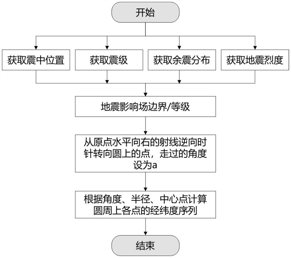
[0058] Known from the prior art, the definition of earthquake influence field is to calculate the spatial influence range of the current earthquake based on the basic elements of the earthquake situation and ground motion parameters, and classify it according to the degree of influence. Among them, the basic elements of the earthquake situation include the longitude and latitude of the epicenter, the magnitude, and the depth of the epicenter. The basic elements of the earthquake situation are determined and updated according to the earthquake situation reported by the China Earthquake Network Center.

[0059] In order to obtain the location data of the entire population in the disaster area, it is first necessary to ensure the range of the earthquake impact field, and then determine the affected persons within the range of the earthquake impact field. If the earthquake impact field cannot be drawn accurately, the earthquake area and the personnel in the eart...

Example Embodiment

[0074] Example 3

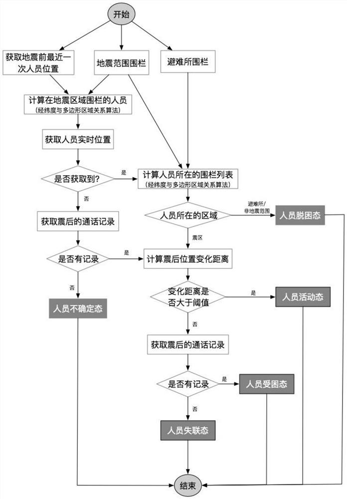
[0075] When an earthquake occurs, obtaining personnel location information is the most critical information in implementing rescue work. In this embodiment, the mobile phone and other wireless terminals are used as position detectors, and the positioning data of "GPS+communication base station" are used to complement each other, and the position data of multiple dimensions such as population and household registration, GPS, Internet, and communication signaling are used to ensure the acquisition of the disaster area. location data. Due to the strong mobility of personnel, the realization of personnel positioning is the first problem of this model, and after personnel positioning, it is also necessary to carry out corresponding rescue work according to the activity status of the victims, and obtaining the activity status of the victims is the second problem of this model problem. In order to accurately obtain the location and activity status of the affected...


PUM


Abstract

The invention provides an earthquake emergency rescue-oriented earthquake population thermodynamic diagram calculation method, which comprises the following steps: taking a mobile phone and other wireless terminals as position detectors, mutually supplementing positioning data of a global positioning system (GPS) and a communication base station, and ensuring acquisition of positioning data of all members in a disaster area by using position data of multiple dimensions such as population household registration, the GPS, the internet and communication signaling. According to the invention, the updating frequency of the Internet IP address, the GPS positioning data and the base station communication positioning data is higher, the time fineness is better, the time resolution and the spatial resolution are higher, and the requirement for the updating frequency of the seismic population data is met.

Description

technical field [0001] The invention relates to the field of point layout, in particular to a method for calculating an earthquake population thermodynamic map oriented to earthquake emergency rescue. Background technique [0002] After the earthquake, the number of people in the earthquake area and their spatial distribution, as well as the location of trapped and lost people are the direct basis for assisting in earthquake emergency response, search and rescue, and disaster reduction, and are also issues of greatest concern to the public. The traditional earthquake emergency population statistics method mainly relies on household registration statistics and ground manual surveys, which cannot meet the timeliness requirements of disaster relief decision-making during the black-box period of earthquakes. Moreover, with the rapid economic development in recent years and the increase in population mobility, there may be a large discrepancy between the actual population situati...

Claims


Application Information

Patent Timeline
IPC IPC(8): G06F16/242G06F16/2457G06F16/26G06F16/29
CPCG06F16/242G06F16/24575G06F16/26G06F16/29
Inventor 刘小利夏涛李盛乐李力刘珠妹陈晓琳刘坚詹聪
Owner 湖北省地震局
Why Eureka
Try Eureka