Land value conduction platform and method based on big data and GIS

A technology of big data and value, applied in the field of big data application, can solve the problems of low land development and utilization value, asymmetric land value information, etc., and achieve the effect of improving development and utilization value and accurate market positioning.

Pending Publication Date: 2021-09-03
重庆华地空间科技有限公司
View PDF0 Cites 0 Cited by
  • Summary
  • Abstract
  • Description
  • Claims
  • Application Information

AI Technical Summary

Problems solved by technology

[0003] The technical problem solved by the invention lies in the low value of land development and utilization caused by the asymmetry of land value information when current investors position the market

Method used


Image

  • Land value conduction platform and method based on big data and GIS
  • Land value conduction platform and method based on big data and GIS

Examples


Embodiment 1

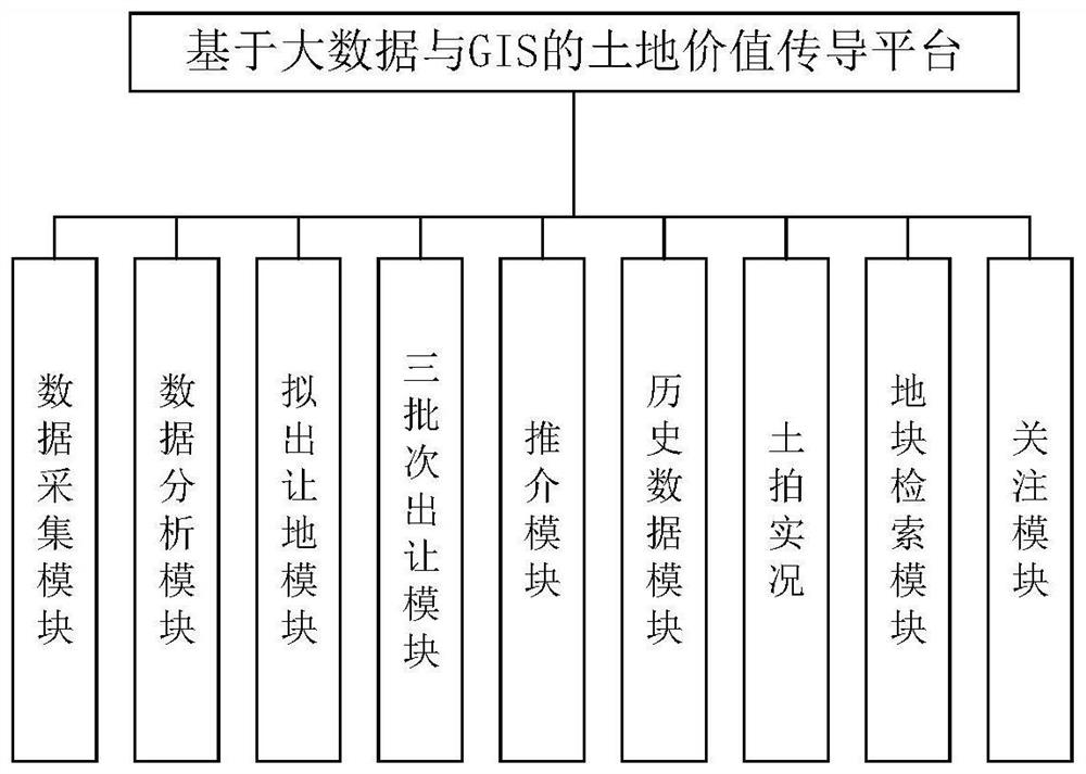
[0049] Embodiment one is basically as attached figure 1 As shown, the land value transmission platform based on big data and GIS includes data acquisition module, data analysis module, proposed land transfer module, three-batch transfer module, recommendation module, historical data module, retrieval module, attention module, and real land auction module and Soil Shooting Calendar module.

[0050] In this embodiment, the data acquisition module uses crawler technology to grab real estate data on the Internet, and then obtains GIS data from the geospatial data cloud, and then processes the acquired data through the data analysis module to obtain land parcel information and surrounding land parcel information. Data information, and then remove redundant data and invalid information to improve its data availability.

[0051] The retrieval module is used to allow users to filter the land parcel information according to multiple conditions such as area, transfer method, land use n...

Embodiment 2

[0060] The difference between the second embodiment and the first embodiment is that the second embodiment also includes a physical environment quality assessment module. The GIS data also includes the offshore distance of the block, geological structure information and site conditions. The physical environment assessment quality is used to evaluate the physical environment quality of the target plot based on GIS data and display it to the user. The total score of the physical environment quality is 7 points, and the assessment elements include offshore distance, geological structure and site conditions. In the evaluation of the offshore distance, the score for the offshore distance is less than one kilometer is 2 points, the score between 3-5 kilometers is 3 points, and the score is more than five kilometers. The score of the plot in the area is 1 point, and the score of the plot in the area of ​​monocline or horizontal rock structure is 2 points; in the evaluation of site co...

Embodiment 3

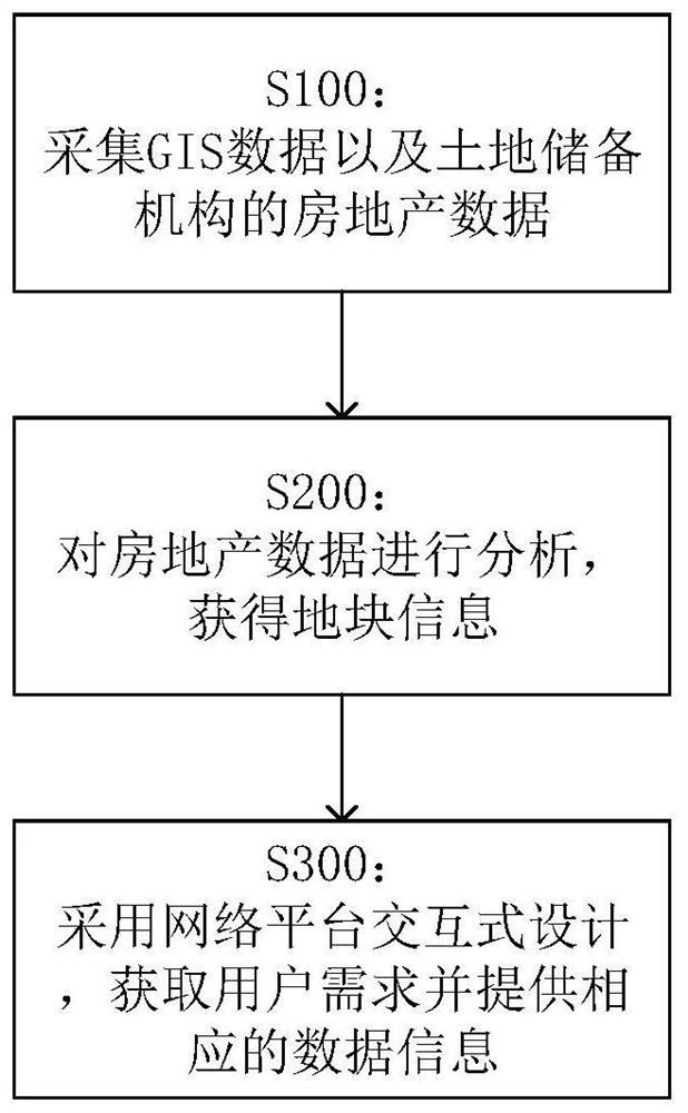
[0062] The difference between Embodiment 3 and Embodiment 2 is that Embodiment 3 is a land value transmission method based on big data and GIS, and any one of the land value transmission methods based on big data and GIS in Embodiment 1 or Embodiment 2 is adopted. platform; embodiment three is basically as attached figure 2 shown, including steps:

[0063] S100: Collect GIS data and real estate data of land reserve institutions;

[0064] S200: Analyze real estate data to obtain land parcel information;

[0065] S300: Adopt the interactive design of the network platform to obtain user needs and provide corresponding data information;

[0066] The S300 includes the steps of:

[0067] S301: Interact with users through the network platform to obtain user needs;

[0068] S302: According to user needs, convert land parcel information and GIS data into data dimensions corresponding to user demands, and generate land parcel value information;

[0069] S303: Provide the land parc...


PUM


Abstract

The invention relates to the technical field of big data application, in particular to a land value conduction platform and method based on big data and GIS. GIS data and real estate data are collected, then the real estate data are fused through a multivariate heterogeneous data fusion technology, land parcel information is generated, then user requirements are obtained through a network platform, then the land parcel information and the GIS data are converted into data dimensions required by the user according to user requirements, corresponding land parcel value information is generated and provided for the user, and the user can timely and accurately know the land value information, so that the market is accurately positioned, the investment failure probability is reduced, meanwhile, the user can better develop and utilize the land, and the development and utilization value of the land is improved.

Description

technical field [0001] The invention relates to the field of big data application technology, in particular to a land value transmission platform and method based on big data and GIS. Background technique [0002] In the real estate industry, real estate companies often need to use huge manpower, material resources and energy to open up new markets. If the market positioning is inaccurate or deviated, it will bring huge losses to investors and the company itself in the later stage. Devastating, from this we can see the importance of market positioning to market development in the real estate industry. However, in order to achieve precise positioning of the market, there must be a sufficient amount of information and data for real estate industry researchers to analyze and judge. However, when investors are positioning the market, they usually have insufficient information on land plots obtained from land reserve agencies, which leads to the problem of asymmetric land value ...

Claims


Application Information

Patent Timeline
Patent Type & Authority Applications(China)
IPC IPC(8): G06Q10/10G06Q30/02G06Q50/16G06F16/29
CPCG06Q10/103G06Q30/0201G06Q30/0203G06Q50/165G06F16/29
Inventor 赵宏伟吴小波
Owner 重庆华地空间科技有限公司
Why Eureka
Try Eureka