Remote sensing image building extraction and contour optimization method based on deep learning

A remote sensing image and deep learning technology, applied in neural learning methods, image enhancement, image analysis, etc., to reduce network size, overcome learning performance degradation and gradient explosion, and eliminate the semantic gap.

Active Publication Date: 2021-10-19
XUZHOU NORMAL UNIVERSITY
View PDF6 Cites 9 Cited by
  • Summary
  • Abstract
  • Description
  • Claims
  • Application Information

AI Technical Summary

Problems solved by technology

However, how to find the best architecture for deep convolutional neural networks is still a great challenge

Method used


Image

  • Remote sensing image building extraction and contour optimization method based on deep learning
  • Remote sensing image building extraction and contour optimization method based on deep learning
  • Remote sensing image building extraction and contour optimization method based on deep learning

Examples


Embodiment Construction

[0083] In order to have a clearer understanding of the technical features, purposes and effects of the present invention, now refer to the accompanying drawings in detail

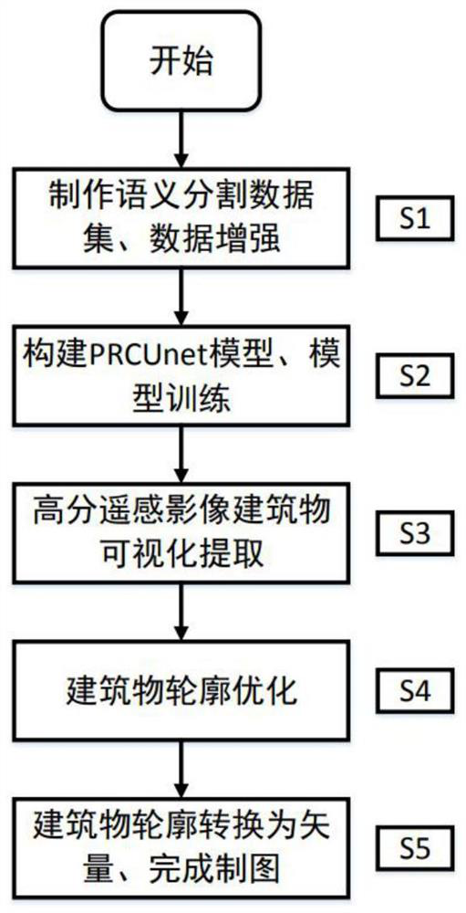
[0084] Such as figure 1As shown, the deep learning-based remote sensing image building extraction and contour optimization method of the present invention, the specific steps are as follows:

[0085] S1, making semantic segmentation data set, data enhancement

[0086] S1.1. Make semantic segmentation dataset

[0087] Use the data labeling tool Arcmap to read several remote sensing image datasets, and manually frame the buildings on each remote sensing image with polygons to generate building vectors. The building vector labels are used to indicate the location and boundary of the building. The area not selected by the box is the background; the building vector is converted into raster data corresponding to the size of the remote sensing image, and the style is resampled to binary raster data, that is, the...


PUM


Abstract

The invention provides a remote sensing image building extraction and contour optimization method based on deep learning, and belongs to the field of environment measurement. The thought of semantic segmentation is applied to building extraction, and building contour optimization is carried out by fusing the Hausdorff distance. A residual structure, a convolution attention module and pyramid pooling are introduced into a Unet model by utilizing the feature extraction capability of a residual module, the balance capability of a convolution attention module on space information and channel information and the multi-scale scene analysis characteristic of a pyramid pooling module, a PRCUnet model is established, semantic information and detail information are concerned at the same time, and the defect of Unet on small target detection is made up. According to the method, the used data set IoU and the recall rate both reach 85% or above, the precision is remarkably superior to that of a Unet model, the precision of the extracted building is higher, and the optimized building boundary is closer to the boundary contour of a real building.

Description

technical field [0001] The invention relates to a remote sensing image building extraction and contour optimization method, and is especially suitable for a deep learning-based remote sensing image building extraction and contour optimization method used in the field of surveying and cartography. Background technique [0002] With the rapid development of earth observation technology, the spatial resolution of remote sensing images has been significantly improved, and more accurate geometric structures, texture features, and richer ground object information can be obtained from remote sensing images. Building extraction based on remote sensing images is an important direction for target recognition. Buildings are of great significance to urban planning, change detection, and disaster management, and are also important basic data for location-based services. The rich data of remote sensing images provides a good data basis for building extraction. Therefore, building extracti...

Claims


Application Information

Patent Timeline
Patent Type & Authority Applications(China)
IPC IPC(8): G06K9/46G06K9/62G06K9/34G06N3/04G06N3/08G06T3/40G06T7/10
CPCG06N3/08G06T7/10G06T3/4038G06T2207/20132G06T2207/10032G06T2207/30204G06T2207/20081G06T2207/20084G06N3/048G06N3/045G06F18/214
Inventor 徐佳伟刘伟
Owner XUZHOU NORMAL UNIVERSITY
Why Eureka
Try Eureka