System, method, device and storage medium for automatically dividing traffic areas in road network

A traffic area, automatic division technology, applied in the field of intelligent transportation, can solve the problem that the boundary of the traffic area is far from the real road, and it is difficult to apply, and achieve the effect of fast calculation speed, less basic data, and good generalization ability

Active Publication Date: 2022-03-18
SHENZHEN URBAN TRANSPORT PLANNING CENT +1
View PDF7 Cites 0 Cited by
  • Summary
  • Abstract
  • Description
  • Claims
  • Application Information

AI Technical Summary

Problems solved by technology

[0015] In view of this, the present application provides a system, method, device and storage medium for automatically dividing traffic areas in a road network, with the purpose of reducing the labor input cost in the process of dividing traffic areas, improving the efficiency of area division, and simplifying user input. The urban road network can be automatically divided by the user, which solves the existing technical solutions for automatically dividing the traffic area. The divided traffic area boundary is far from the real road, requiring too much input data, which is difficult to apply in practice. In the process of model building, therefore, what is built based on the technical solution of this application is a standardized tool that can be used in the division of traffic areas on a large scale

Method used


Image

  • System, method, device and storage medium for automatically dividing traffic areas in road network
  • System, method, device and storage medium for automatically dividing traffic areas in road network
  • System, method, device and storage medium for automatically dividing traffic areas in road network

Examples


Embodiment 1

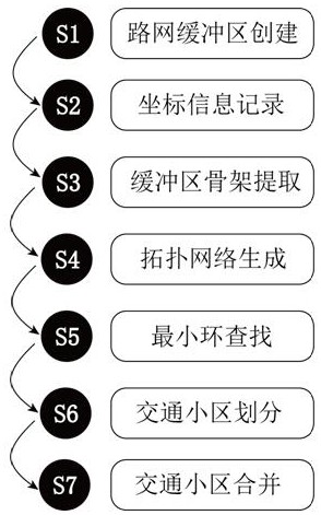
[0116] Embodiment 1 of the present application provides a system for automatically dividing traffic zones based on image technology (see figure 1 ),include:

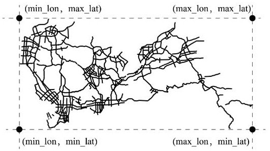
[0117] The road network buffer creation module is used to merge the road networks of complex roads, convert linear vector graphics into area domain vector graphics, and store them in a binary image format;

[0118] The coordinate information recording module is used to calculate the longitude and latitude span of the unit pixel of the binary image;

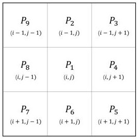
[0119] The central axis skeleton extraction module of the buffer zone, according to the longitude and latitude span of the unit pixel of the binary image, extracts the main line outline of the binary image through iterative calculation to obtain the skeleton image;

[0120] The topological network generation module obtains the topological network based on the skeleton image;

[0121] Find the minimum basic ring module, and use the greedy algorithm to search for the minimu...

Embodiment 2

[0125] Embodiment 2 of the present application provides a method for automatically dividing traffic areas in a road network based on image technology (see Figure 2-Figure 9 ), the method is specifically:

[0126] S1, road network buffer creation,

[0127] The creation of the buffer zone has a relatively important impact on the rationality of the division of the cell. The main purposes of this step are:

[0128] 1) Merge complex roads such as interchanges and multi-line expressways to facilitate the extraction of road centerlines;

[0129] 2) Convert the linear file into a region file and store it as an image format as the input file for extracting the skeleton image.

[0130] The specific steps are:

[0131] Assume that the road network of complex roads has N traffic route links, based on the input road network , the road network information is only required to contain geometric information, and a buffer is created for each link object , convert linear vector graphics ...

Embodiment 3

[0193] Embodiment 3 of the present application provides an electronic device, see Figure 13 , an electronic device in the form of a general-purpose computing device. Components of an electronic device may include, but are not limited to: one or more processors or processing units, memory for storing computer programs that can run on the processors, connections to different system components (including memory, one or more processors or processing unit) bus.

[0194] Wherein, when the one or more processors or processing units are used to run the computer program, execute the steps of the method described in the second embodiment. The types of processors used include central processing units, general purpose processors, digital signal processors, application specific integrated circuits, field programmable gate arrays or other programmable logic devices, transistor logic devices, hardware components or any combination thereof.

[0195] Wherein, the bus refers to one or more o...


PUM


Abstract

The application discloses a system, method, device and storage medium for automatically dividing traffic areas in a road network, belonging to the technical field of intelligent transportation. It solves the problem that the existing automatic division of traffic areas is far from the real road and requires too much input data, which is difficult to apply in the actual model building process. The steps of this application: road network buffer creation, coordinate information recording, buffer central axis skeleton extraction, topology network generation, minimum basic ring search, traffic area division, and traffic area merging. This application forms a new topological network by extracting the road skeleton, and divides the districts based on the urban basic layer. The calculation speed is fast, the input data is simple, the generalization ability is good, and the urban traffic districts can be quickly divided, and the manpower input is small. This application integrates road network skeleton extraction, skeleton to topology, minimum basic ring search, area space analysis algorithm, and provides a complete system and method.

Description

technical field [0001] The present application relates to a system, method, device and storage medium for automatically dividing traffic zones, in particular to a system, method, device and storage medium for automatically dividing traffic zones in a road network based on image technology, which belongs to the field of intelligent transportation technology. Background technique [0002] Traffic model technology is an important theoretical support basis for the transportation industry, which can provide important data support for urban planning and construction. The division of traffic districts is an important part of the traffic model construction process. Whether the division of traffic districts is reasonable or not is directly related to the accuracy of the completed traffic model. Then, the division of traffic districts is a relatively cumbersome process that requires a lot of manpower. In order to simplify the cumbersome division of traffic areas, many methods of autom...

Claims


Application Information

Patent Timeline
Patent Type & Authority Patents(China)
IPC IPC(8): G06T7/13G06T7/187G06F16/29
CPCG06T7/13G06T7/187G06F16/29
Inventor 唐铠屈新明刘晓玲吕锴超罗旭彬林虹君郑之帼
Owner SHENZHEN URBAN TRANSPORT PLANNING CENT
Why Eureka
Try Eureka