Surface temperature high-temperature and low-temperature data set reconstruction method

A surface temperature and data set technology, applied in special data processing applications, design optimization/simulation, etc., can solve the problems of lack of spatial continuity, uneven site distribution, low spatial resolution, etc., to facilitate climate-related analysis, improve The effect of data precision and high spatial resolution

Active Publication Date: 2021-12-07
INST OF AGRI RESOURCES & REGIONAL PLANNING CHINESE ACADEMY OF AGRI SCI
View PDF5 Cites 0 Cited by
  • Summary
  • Abstract
  • Description
  • Claims
  • Application Information

AI Technical Summary

Problems solved by technology

[0003] At present, ground observation data has time continuity at a single point, but lacks spatial continuity due to the uneven distribution of stations and poor representation of spatial heterogeneity. Satellite remote sensing data can be used for large-scale space observation, but is limited by sensor transit time and The impact of cloud and rain weather lacks time continuity

Method used


Image

  • Surface temperature high-temperature and low-temperature data set reconstruction method
  • Surface temperature high-temperature and low-temperature data set reconstruction method
  • Surface temperature high-temperature and low-temperature data set reconstruction method

Examples


Embodiment 1

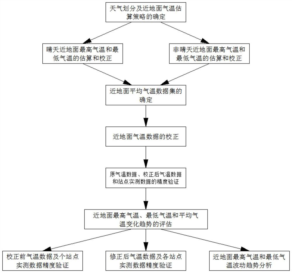
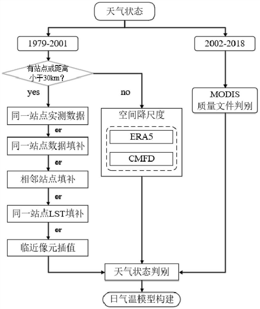
[0029] according to figure 1 , 2 , 3, the present embodiment provides a surface temperature high temperature and low temperature data set reconstruction method, including the following steps:

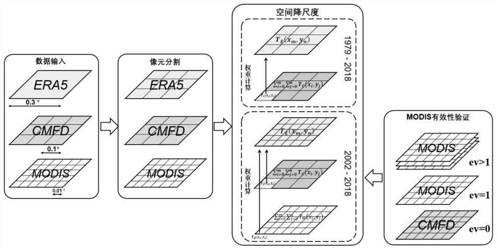
[0030] Step 1. Divide the daily weather into sunny weather and non-sunny weather with the help of the quality control field that comes with MODIS and the measured data at the site. The quality control field that comes with MODIS is used to identify the weather status in the period from 2002 to 2021. The first is to use multi-temporal methods to fill in data in the pixel area when there is a corresponding meteorological station at the pixel position and the Euclidean distance between adjacent stations is less than 0.3°;

[0031] The measured data of the stations are used to distinguish the weather state in the period from 1979 to 2001, and to analyze the two estimation strategies of near-surface air temperature. For areas where the station distribution is relatively sparse and the Eucli...

Embodiment 2

[0045] according to figure 1 , 2 , 3, the present embodiment provides a surface temperature high temperature and low temperature data set reconstruction method, including the following steps:

[0046] Step 1. Divide the daily weather into sunny weather and non-sunny weather with the help of the quality control field that comes with MODIS and the measured data at the site. The quality control field that comes with MODIS is used to identify the weather status in the period from 2002 to 2021. The first one is to use the method of spatial correlation to fill in the data of the pixel area when the pixel position has a corresponding meteorological station and the Euclidean distance between adjacent stations is less than 0.3°;

[0047] The measured data of the stations are used to distinguish the weather state in the period from 1979 to 2001, and to analyze the two estimation strategies of near-surface air temperature. For areas where the station distribution is relatively sparse an...


PUM


Abstract

The invention discloses a surface temperature high-temperature and low-temperature data set reconstruction method. Different estimation models of near-surface air temperature data are constructed for different weathers through the division of different weathers, the maximum value and minimum value of the air temperature and the average air temperature of each day are calculated then temperature correction models of different areas are built according to natural conditions of different areas in China, correction and precision evaluation are further conducted on the highest temperature, the lowest temperature and the average temperature, a highest temperature data set, a lowest temperature data set and an average temperature data set are built, and fluctuation trends of the highest temperature and the lowest temperature are analyzed on the basis of the highest temperature data set, the lowest temperature data set and the average temperature data set. Sunny day and non-sunny day weather states are distinguished, a plurality of evaluation indexes are adopted to analyze the temporal and spatial change trend of near-surface air temperature, CMFD data and an ERA5 data set are taken as reanalysis data sources, the method has relatively high spatial resolution and reliable precision, the regional air temperature change condition can be accurately captured, and climate correlation analysis and research on other earth surface driving factors are facilitated.

Description

technical field [0001] The invention relates to the technical field of near-surface air temperature data reconstruction, in particular to a method for reconstructing surface temperature high temperature and low temperature data sets. Background technique [0002] Near-surface temperature is an important variable that reflects global climate change, and significantly affects the cycle conversion of energy and matter in various layers of the earth. In particular, the daily maximum temperature, minimum temperature and average temperature near the surface are important for the study of atmospheric cycle conversion, climate change and extreme weather. The magnitude and frequency of events is significant; [0003] At present, ground observation data has time continuity at a single point, but lacks spatial continuity due to the uneven distribution of stations and poor representation of spatial heterogeneity. Satellite remote sensing data can be used for large-scale space observatio...

Claims


Application Information

Patent Timeline
IPC IPC(8): G06F30/20
CPCG06F30/20
Inventor 毛克彪方舒王平夏学齐孟飞袁紫晋
Owner INST OF AGRI RESOURCES & REGIONAL PLANNING CHINESE ACADEMY OF AGRI SCI
Why Eureka
Try Eureka