A method for high-precision photography and quality control of complex structural water engineering UAV

A quality control method and complex structure technology, applied in the direction of TV, color TV parts, TV system parts, etc., can solve the problems of low shooting flexibility, dam break, and lack of texture in oblique images, so as to ensure quality and job efficiency, reduce job time, and avoid the effect of texture compression

Active Publication Date: 2022-01-11
长江空间信息技术工程有限公司(武汉)
View PDF4 Cites 0 Cited by
  • Summary
  • Abstract
  • Description
  • Claims
  • Application Information

AI Technical Summary

Problems solved by technology

Moreover, most of the water projects in our country were built decades ago. Due to the low flood control standards and poor construction quality at that time, after decades of use, there are varying degrees of aging and deformation; once the engineering deformation exceeds the allowable limit, it will cause The danger of cracks, leakage and dam failure; therefore, high-precision and fine-grained spatial data collection for water projects is an important requirement for the national economy and people's livelihood;
[0004] In order to obtain high-resolution and high-quality images of the scene target, the existing methods generally use oblique photogrammetry or close-range photogrammetry for data collection; oblique photogrammetry usually uses multi-lens cameras to capture data, and one exposure can obtain multiple images of the target scene. Angle-of-view images have higher data acquisition efficiency for large-scale target scenes; however, since oblique photogrammetry is shot from top to bottom and the camera angle is fixed, it cannot adapt to the complex structure of water projects, so when it is close to the bottom of water projects, the oblique images The more serious the problem of missing and deformed textures;
[0005] Close-range photogrammetry is ground photogrammetry with a photographing distance of 100 meters. Although its theory and methods have been greatly developed in recent years, there are still frequent mobile shooting base stations in engineering applications, and even scaffolding is built to complete the shooting, resulting in The problems of low flexibility, low efficiency and high cost;
[0006] Both existing methods have deficiencies; in addition, during the shooting process, there are some relatively complex areas (such as large space fluctuations, complex structures, etc.), and there may be situations where fine and complete modeling effects cannot be obtained in one shot; from the quality From the perspective of control, supplementary flight is required; however, the current method of supplementary flight is that the operator manually operates the drone to take pictures of the supplementary flight area one by one, which is not only inefficient, but also has high requirements for the operator;

Method used


Image

  • A method for high-precision photography and quality control of complex structural water engineering UAV
  • A method for high-precision photography and quality control of complex structural water engineering UAV
  • A method for high-precision photography and quality control of complex structural water engineering UAV

Examples


Embodiment

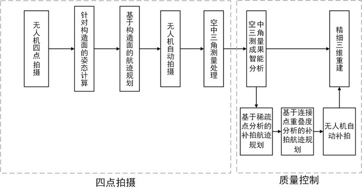
[0097] The present invention is to be applied to a large-scale hydropower UAV precision and quality control of the photography of the present invention in detail, the present invention is applicable to other complex structures UAV water engineering and quality control precision photography has the same guide.

[0098] In this embodiment, a large high-precision photography UAV station and quality control method, comprising the steps of:

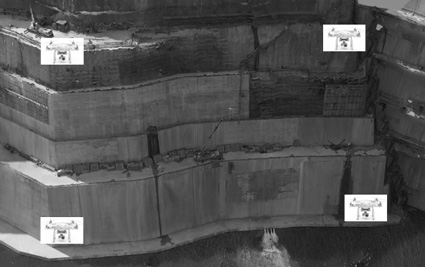
[0099] Geographical coordinates according to the characteristics of the shape of a large slope station, with manual shooting RTK UAV rotor in the vicinity of four corners of each face of a large-scale hydropower engineering goals to give the four corner points of the water: Step 1 (like figure 2 As shown in the white boxes represent rotorcraft UAV with RTK for imaging in the vicinity of four corners of each face of the station);

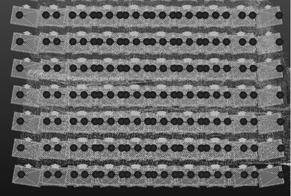
[0100] Step 2: Step 1 using the four corner points of the image obtained the drone, the calculated imaging range and t...


PUM


Abstract

The invention discloses a high-precision photography and quality control method of a complex structure water engineering drone. It includes the following steps: Step 1: Four-point shooting by UAV; Step 2: Extract the geographical coordinates of the four corner points from the EXIF ​​information of the four images obtained in Step 1; Step 3: Calculate the attitude of the structural surface, Track planning based on structural surface; Step 4: UAV automatic shooting; Step 5: Aerial triangulation processing, intelligent analysis of aerial triangulation results; Step 6: Supplementary shooting track planning based on connection point overlap analysis; Step 7 : UAV automatic supplementary shooting; Step 8: According to the high-resolution images obtained in Step 4 and Step 7, perform precise geometric positioning and fine dense matching to obtain fine and high-precision water engineering geographic information products. The invention has the advantages of being able to quickly acquire high-resolution images and automatically perform quality control.

Description

Technical field [0001] The present invention relates to a water engineering data acquisition, and more particularly it is a complex structure with high precision photography UAV Water Engineering and quality control method; [0002] With a surface water project will be able to fit a simple construction of water projects, such as dams along the coast and other rules; refers to the complex structure of water projects need to use more surface water to be fully fit projects, such as large hydroelectric power plants. Background technique [0003] Water project is the spatial and temporal distribution of water resources regulation, important to optimize allocation of water resources engineering facilities. my country is one of the world's largest construction scale national project in Sheung Shui, water projects throughout the country, it plays a huge benefit in terms of flood control, irrigation, power generation, water supply and so on; however, the majority of water projects are the...

Claims


Application Information

Patent Timeline
Patent Type & Authority Patents(China)
IPC IPC(8): G01C11/34G01C11/02H04N5/232
CPCG01C11/34G01C11/02H04N23/64
Inventor 杨爱明马能武钟良陶鹏杰张辛席可杨洋杨俊
Owner 长江空间信息技术工程有限公司(武汉)
Why Eureka
Try Eureka