Space-spectrum information combined spaceborne hyperspectral image segmentation and clustering method

An image segmentation and clustering method technology, applied in image analysis, image enhancement, image data processing and other directions, can solve the problems of large number of bands, high cost, harsh model conditions, etc., to achieve the effect of simple operation and high degree of automation

Active Publication Date: 2022-01-07
自然资源部国土卫星遥感应用中心
View PDF10 Cites 1 Cited by
  • Summary
  • Abstract
  • Description
  • Claims
  • Application Information

AI Technical Summary

Problems solved by technology

Pixel-based segmentation is relatively simple and easy to implement, and is suitable for relatively simple images with a small amount of data; edge detection-based segmentation is mainly used for contour extraction, and it is still difficult to apply to images with multiple bands and indistinct edge information; The region-based method mainly uses the similarity of pixel features in the region to segment the image. This type of method mainly includes two methods: region growth and region splitting and merging, represented by the watershed algorithm. This type of algorithm is easy to extend to multi-band, but the cost Higher; while the physical model-based segmentation method can identify shadows, light spots, etc., and can obtain the boundaries of objects in high-resolution images, but is limited by the harsh model conditions
For hyperspectral data, the spatial spectral information joint segmentation and clustering algorithm that combines spectral information with spatial features such as shape and texture can improve the segmentation and clustering effect to a certain extent, but most of the existing algorithms are suitable for high spatial resolution. , airborne hyperspectral images with relatively simple types of ground objects and a large number of pixels of ground objects, while for spaceborne hyperspectral images with complex types of ground objects, few pixels of ground objects, large number of bands, and high data redundancy Hyperspectral imagery applications are very limited

Method used


Image

  • Space-spectrum information combined spaceborne hyperspectral image segmentation and clustering method
  • Space-spectrum information combined spaceborne hyperspectral image segmentation and clustering method
  • Space-spectrum information combined spaceborne hyperspectral image segmentation and clustering method

Examples


Embodiment Construction

[0022] In order to make the object, technical solution and advantages of the present invention clearer, the present invention will be further described in detail below in conjunction with the embodiments and accompanying drawings.

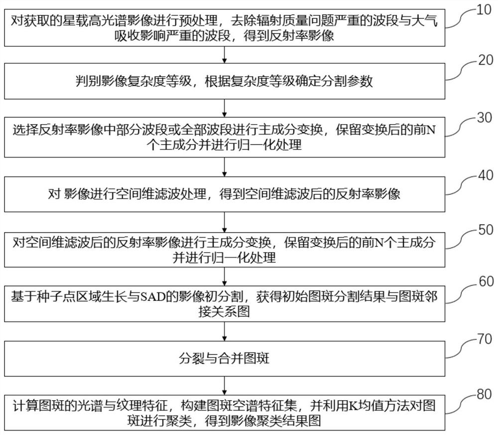
[0023] like figure 1 As shown, the process flow of the space-borne hyperspectral image segmentation and clustering method for the combination of space-spectrum information proposed by the present invention includes the following steps:

[0024] Step 10 preprocesses the acquired spaceborne hyperspectral images, removes the bands with serious radiation quality problems and the bands with serious atmospheric absorption effects, and obtains reflectance images;

[0025] Step 20 judges the complexity level of the image, and determines the segmentation parameters according to the complexity level; the segmentation parameters include the filter window size WinSize, the similarity threshold Sim, and the number of filtering iterations FN;

[0026] Step 30 s...


PUM


Abstract

The invention discloses a space-spectrum information combined satelliteborne hyperspectral image segmentation and clustering method, which comprises the following steps of: preprocessing an acquired satelliteborne hyperspectral image, and removing a wave band with a serious radiation quality problem and a wave band with a serious atmospheric absorption influence to obtain a reflectivity image; judging the complexity level of the image, and determining segmentation parameters according to the complexity level; selecting part of wave bands or all wave bands in the reflectivity image to carry out principal component transformation, retaining the first N principal components after transformation, and carrying out normalization processing; performing spatial dimension filtering processing on the image; principal component transformation is carried out on the reflectivity image after spatial dimension filtering, and the first N principal components after transformation are reserved and normalized; obtaining an initial pattern spot segmentation result and a pattern spot adjacency relation graph based on seed point region growth and image initial segmentation of SAD; splitting and combining the pattern spots; and calculating spectrum and texture features of the pattern spots, constructing a pattern spot spatial spectrum feature set, and clustering the pattern spots by using a K-means method to obtain an image clustering result image.

Description

technical field [0001] The invention relates to the technical field of segmentation and clustering of space-borne hyperspectral images, in particular to a method for segmentation and clustering of space-borne hyperspectral images combined with space-spectral information. Background technique [0002] Compared with traditional surveying and mapping technology, remote sensing has the advantages of large detection range, fast data acquisition, short repeated observation cycle, and less restriction by ground conditions. Among them, spaceborne hyperspectral data contains hundreds of spectral channels, which contain rich spectral information. Compared with ground and aerial remote sensing, hyperspectral satellite remote sensing can obtain macro-scale ground feature information quickly, in a large range, and at high frequencies, greatly improving the quantitative investigation and monitoring capabilities of natural resource elements. [0003] Segmentation and clustering of remote ...

Claims


Application Information

Patent Timeline
Patent Type & Authority Applications(China)
IPC IPC(8): G06T7/11G06K9/62
CPCG06T7/11G06T2207/10032G06T2207/30184G06T2207/30188G06F18/23
Inventor 尚坤魏红艳
Owner 自然资源部国土卫星遥感应用中心
Why Eureka
Try Eureka