Anti-crystallization underwater terrain detection method and system

An underwater terrain and underwater detection technology, applied in radio wave measurement systems, geophysical measurements, measurement devices, etc., can solve the problems of delayed production progress, limited measurement accuracy, poor intuition, etc., to prevent the adhesion of crystal nuclei, Improves visibility and avoids the effect of external crystallization

Pending Publication Date: 2022-02-01
CINF ENG CO LTD
View PDF0 Cites 0 Cited by
  • Summary
  • Abstract
  • Description
  • Claims
  • Application Information

AI Technical Summary

Problems solved by technology

Roller-type or probe-type mechanical water depth measurement devices commonly used at this stage usually sink into the salt layer for a certain distance, and the measurement accuracy is limited; non-contact measurement methods such as water depth radar or acoustic wave meter usually form salt on the surface of the equipment after a period of use If the shell affects the normal measurement, it must be manually disassembled and cleaned, which will inevitably increase the workload of personnel and delay the production schedule.
[0003] At present, there are relatively few scientific research and transformation results on underwater measurement of high-concentration brine bodies. Problems such as saturated brine crystallization have not yet been solved, and the use of physical layer equipment has also restricted the promotion and application of advanced control theory.
The thickness of the underwater salt layer in brine mining sites mostly adopts a two-dimensional plane display method, which is usually only used as a qualitative reference, which is poorly intuitive and cannot be directly used as a direct basis for the operation and control of the brine mining system, and cannot be used for real-time and accurate underwater terrain detection.

Method used


Image

  • Anti-crystallization underwater terrain detection method and system
  • Anti-crystallization underwater terrain detection method and system
  • Anti-crystallization underwater terrain detection method and system

Examples


Embodiment Construction

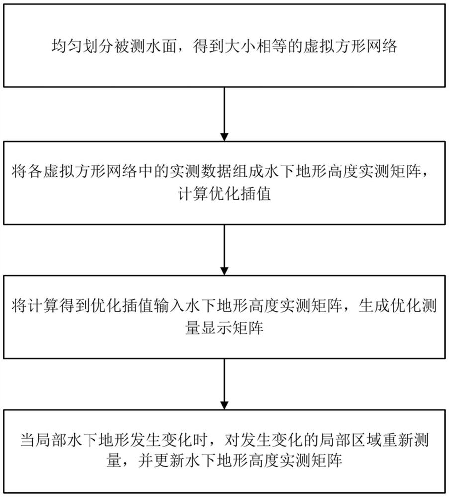
[0031] like figure 1 It is a schematic flow chart of the method of the present invention: the anti-crystallization underwater terrain detection method provided by the present invention comprises the following steps:

[0032] S1. Evenly divide the measured water surface to obtain a virtual square network of equal size;

[0033] Step S1 specifically takes the center of the grid as the measurement point. When the hull of the survey ship reaches the center point of the grid, send a measurement command and complete a measurement, record the water depth data and back it up.

[0034] S2. Composing the measured data in each virtual square network into a measured matrix of underwater terrain height, and calculating an optimized interpolation value;

[0035] Step S2 is specifically to calculate the terrain height between the measurement points by using the matrix expansion method; the optimized interpolation algorithm used is:

[0036]

[0037]Among them, f(x) represents the optima...


PUM


Abstract

The invention discloses an anti-crystallization underwater terrain detection method, which comprises the following steps of: uniformly dividing a detected water surface to obtain virtual square networks with the same size; forming an underwater terrain height actual measurement matrix by the actual measurement data in each virtual square network, and calculating an optimization interpolation; inputting the optimized interpolation obtained through calculation into the underwater terrain height actual measurement matrix, and generating an optimized measurement display matrix; and when the local underwater topography changes, re-measuring the changed local area, and updating the underwater terrain height actual measurement matrix. The invention further discloses a system based on the anti-crystallization underwater terrain detection method. According to the anti-crystallization underwater terrain detection method, the visuality of data feedback is improved by utilizing an optimized Shepard method; and cellulose acetate permeable membranes are used for respectively wrapping a transmitting transducer and an echo detector, purified water is injected and pressurized by a booster pump, and the purified water penetrates through the permeable membranes under the combined action of osmotic pressure and pressurization of the booster pump to prevent crystal nucleus from being attached, so that external crystallization of the detector is prevented from influencing measurement.

Description

technical field [0001] The invention belongs to the field of underwater detection, and in particular relates to a crystallization-proof underwater terrain detection method and system. Background technique [0002] my country has a vast territory and is rich in brine mineral resources. Efficient use of brine resources is of great significance for consolidating national defense security and improving people's livelihood and economy. Natural evaporation is an important means of industrial brine extraction, that is to accelerate the saturation of the solution by sun exposure and other methods, so that the mineral salts are precipitated and deposited, and then directly fished for processing and utilization. For industrial salt fields, accurate detection of the distribution of underwater mineral deposits can help improve operational efficiency and reduce production costs. However, large-scale salt pans cover tens or even hundreds of square kilometers, and factors such as drainage...

Claims


Application Information

Patent Timeline
Patent Type & Authority Applications(China)
IPC IPC(8): G01S15/89G01V9/00
CPCG01S15/89G01V9/00
Inventor 潘岩鄢锋曾祥吉杨静雅施耘黄君
Owner CINF ENG CO LTD
Why Eureka
Try Eureka