Time-varying sea surface airborne SAR imaging simulation method based on CSA algorithm

A simulation method and imaging technology, applied in the direction of reflection/re-radiation of radio waves, use of re-radiation, measurement devices, etc., can solve the problems of increasing errors and increasing the "dependency of main channel imaging", reducing time-consuming and simulation accuracy. improved effect

Active Publication Date: 2022-02-15
OCEAN UNIV OF CHINA
View PDF6 Cites 2 Cited by
  • Summary
  • Abstract
  • Description
  • Claims
  • Application Information

AI Technical Summary

Problems solved by technology

In actual observation, the radar antenna with multi-channel is usually mounted on the airborne platform to measure the target area. However, the traditional simulation generates a main image at a time, and the secondary image is obtained through the scattered field in the main channel. Adding the phase difference calculated by the carrier parameters and sea surface parameters and random noise generation, there is a certain bias with the actual measurement situation, which increases the error brought by the simulation process to a certain extent, and increases the influence on the main Channel Imaging "Dependencies"

Method used


Image

  • Time-varying sea surface airborne SAR imaging simulation method based on CSA algorithm
  • Time-varying sea surface airborne SAR imaging simulation method based on CSA algorithm
  • Time-varying sea surface airborne SAR imaging simulation method based on CSA algorithm

Examples


Embodiment 1

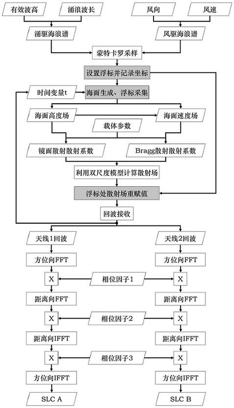
[0050] A time-varying sea surface airborne SAR imaging simulation method based on CSA algorithm, comprising the following steps (such as figure 1 shown):

[0051] 1) Calculate the wind-driven wave spectrum and surge-driven wave spectrum by inputting the simulation parameters of the two-dimensional scene;

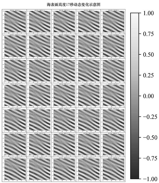
[0052] In the early stage of sea simulation, the following coordinate system needs to be established: define the x-axis as the distance direction, the y-axis as the azimuth direction, that is, the direction of the carrier flight, define the z-axis as the vertical direction, and set the size of the two-dimensional rough sea scene as (N x ∆ x ) × (N y ∆ y ), where, ∆ x is the scene resolution in the distance direction of the two-dimensional rough sea scene, ∆ y is the scene resolution in the azimuth direction of the 2D rough sea scene , N x is the number of scene units whose distance is upward in the two-dimensional rough sea scene, N y is the number of scene units in ...

Embodiment 2

[0070] This embodiment is based on Embodiment 1, and an actual simulation experiment is carried out.

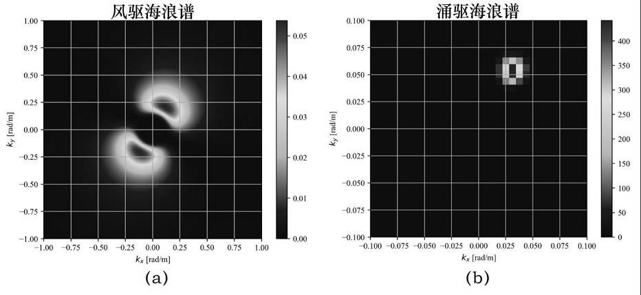
[0071] In the above step 1), the range length of the two-dimensional rough sea scene is Lx=500m, the azimuth length Ly=500m, and the resolution of the range scene is ∆ x =1m, azimuth scene resolution ∆ y =1m, the pm spectrum is selected for the wind-driven wave spectrum and the surge-driven wave spectrum, and the formula is:

[0072]

[0073] in, is a dimensionless empirical constant, and in conventional simulations, Generally defined empirically as , Defined as 0.74, the acceleration due to gravity , k is the space wave number, is the wind speed at the sea surface height of 19.5m. In this example, the wind direction angle is set to 60°, the wind speed is set to 5m / s, the swell propagation direction angle is set to 60°, the swell wavelength is set to 80m, and the effective wave height is set to 1.5 m, to generate the input ocean wave spectrum, figure 2 (a) is...


PUM


Abstract

The invention provides a time-varying sea surface airborne SAR imaging simulation method based on a CSA algorithm. According to the method, the mirror scattering coefficient and the Bragg scattering coefficient are subjected to normalized superposition by using a dual-scale theoretical model, so that the whole process is simulated more finely. Echo collection is carried out on the dynamic sea surface based on the SAR imaging principle, dynamic collection is carried out on the simulated sea surface based on the created virtual buoy, and original echo data are processed into an SAR simulated image spectrum containing speed bunching modulation, tilt modulation and fluid mechanics modulation through the CSA algorithm. The imaging simulation method provided by the invention is improved on the basis of traditional sea surface SAR imaging simulation, the problem that a main image and an auxiliary image cannot be generated at the same time in the simulation process is solved, conflicts with actual measurement work are reduced to a certain extent, errors caused in the simulation process are reduced, and in the future error simulation work, multi-baseline mode simulation has reference significance to a certain extent.

Description

technical field [0001] The invention belongs to the technical field of ocean observation, and in particular relates to a time-varying sea surface airborne SAR imaging simulation method based on a CSA algorithm. Background technique [0002] Synthetic Aperture Radar (SAR) has all-weather, all-time, multi-polarization, and high-resolution earth observation capabilities. Since the 1990s, with the successive implementation of airborne and spaceborne SAR remote sensing programs, a wealth of SAR land observation data has been accumulated. These data can be applied to many aspects such as residential detection, surface subsidence monitoring, and urban economic analysis, fully demonstrating the significance and value of SAR in remote sensing. [0003] However, due to the limitations of spaceborne SAR orbit, airborne SAR flight distance and funding, it is impossible to obtain rich ocean scene data, which also limits people's research on oceanography. Therefore, the two-dimensional r...

Claims


Application Information

Patent Timeline
Patent Type & Authority Applications(China)
IPC IPC(8): G01S13/90
CPCG01S13/9094
Inventor 马纯永潘李超邱志伟梁达陈戈
Owner OCEAN UNIV OF CHINA
Why Eureka
Try Eureka