Method for processing meteorological satellite remote sensing cloud picture

A processing method and meteorological satellite technology, applied in the field of cloud image analysis, can solve the problems of limited meteorological data and inability to realize fusion data, etc.

Pending Publication Date: 2022-03-11
西安中科西光航天科技有限公司
View PDF0 Cites 0 Cited by
  • Summary
  • Abstract
  • Description
  • Claims
  • Application Information

AI Technical Summary

Problems solved by technology

People can obtain different types of weather maps from meteorological satellites, but each weather map has limited meteorological data corresponding to the region, and it is impossible to achieve data fusion

Method used


Image

  • Method for processing meteorological satellite remote sensing cloud picture
  • Method for processing meteorological satellite remote sensing cloud picture
  • Method for processing meteorological satellite remote sensing cloud picture

Examples


Embodiment 1

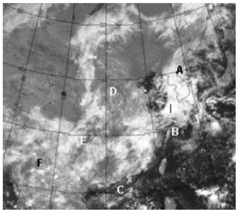
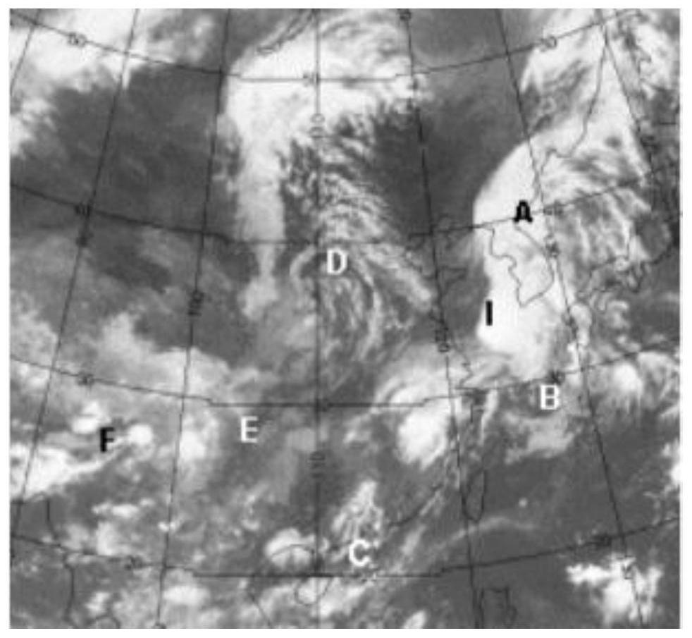
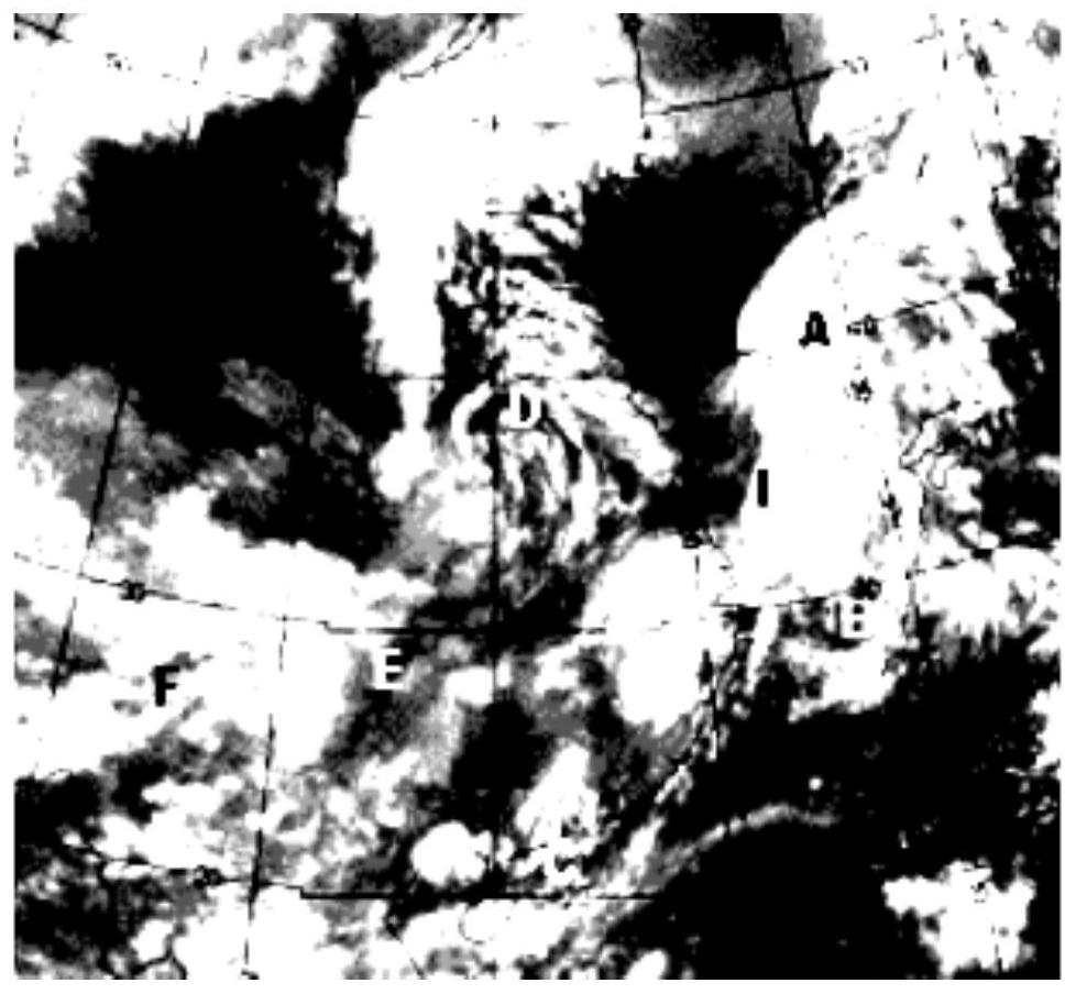
[0036] S1: First obtain images of a certain map through different meteorological satellites, visible light cloud images, (such as figure 1 ), infrared cloud image, (such as figure 2 ), water vapor diagram, (such as image 3 ).

[0037] S2: It can be concluded from the visible light cloud image that point D is a vortex, but there is no indication. Some targets on the visible light cloud image, A-B-C and G-D-E-F on the infrared cloud image show broken clouds, and the vortex at D is relatively obvious. From the water vapor image It is concluded that point D is the vortex and the direction of the surrounding water vapor.

[0038] S3: Perform fusion and multi-scale construction on multiple parameter representations; obtain a fusion image;

[0039] The algorithm of wavelet decomposition and reconstruction is currently the most commonly used Mallat algorithm. For the choice of wavelet function, the wavelet with orthogonal and compact support properties is commonly used at presen...


PUM


Abstract

The invention discloses a meteorological satellite remote sensing cloud picture processing method. The cloud picture processing method comprises the following steps: firstly, acquiring an image 1, an image 2 and an image 3 through different meteorological satellites; performing image decomposition on the image 1, the image 2 and the image 3 to obtain a plurality of parameter representations; performing fusion and multi-scale construction on the plurality of parameter representations; obtaining a fused image; analyzing and processing the fused image; and acquiring and analyzing data of the image. After the structure is adopted, the method has the following advantages that a plurality of parameters are decomposed from the images of the visible light cloud picture, the infrared cloud picture and the water vapor picture, and then image fusion is carried out through a wavelet transform fusion method, so that cloud data can be obtained from a fusion drawing; the weather condition, the cloud trend, the humidity vertical distribution and the like of an image area can be obtained according to the data, and the local weather condition is detected in a high-precision, high-time-efficiency and coverage mode.

Description

technical field [0001] The invention relates to the technical field of cloud image analysis, in particular to a processing method for meteorological satellite remote sensing cloud images. Background technique [0002] With the continuous development of space-to-ground remote sensing technology, the multi-spectral detection information of meteorological satellites has become the most important source of space-based observation data in short-term weather forecasting, sudden natural disaster monitoring, and climate research. The characteristics of high efficiency, high timeliness and wide coverage have brought huge social and economic benefits in the fields of disaster prevention and mitigation, military support and other fields. As an important observation platform for meteorological elements, meteorological satellites mainly detect the vertical distribution of temperature and humidity in the atmosphere, and the radiation information of objects such as clouds and the surface i...

Claims


Application Information

Patent Timeline
IPC IPC(8): G06V20/10G06V10/75G06K9/62
Inventor 秦静祝青
Owner 西安中科西光航天科技有限公司
Why Eureka
Try Eureka