
Fire point positioning correction method based on laser ranging and GIS map

A GIS map, laser ranging technology, applied in the direction of measuring devices, electromagnetic wave re-radiation, geographic information database, etc., can solve the problems of large error of fire point position, failure to obtain fire point position, tourism loss, etc., to achieve automatic fire point Effect of Point Positioning Correction

Pending Publication Date: 2022-04-01
CHINA FORESTRY STAR BEIJING TECH INFORMATION CO LTD
View PDF0 Cites 0 Cited by
  • Summary
  • Abstract
  • Description
  • Claims
  • Application Information

AI Technical Summary

Problems solved by technology

[0005] 2. Loss of current assets
[0007] 3. Loss of fire fighting expenses
[0009] 4. Loss of tourism
This method of locating the fire point has the following problems: the judgment time of the fire point locating process is long, the accurate fire point position cannot be obtained in a short time, and it is highly dependent on the past experience of the forest rangers, and the final fire point The position error is large, and it cannot play a very good role in helping fire fighting and extinguishing

Method used


Image

  • Fire point positioning correction method based on laser ranging and GIS map
  • Fire point positioning correction method based on laser ranging and GIS map
  • Fire point positioning correction method based on laser ranging and GIS map

Examples


Embodiment Construction

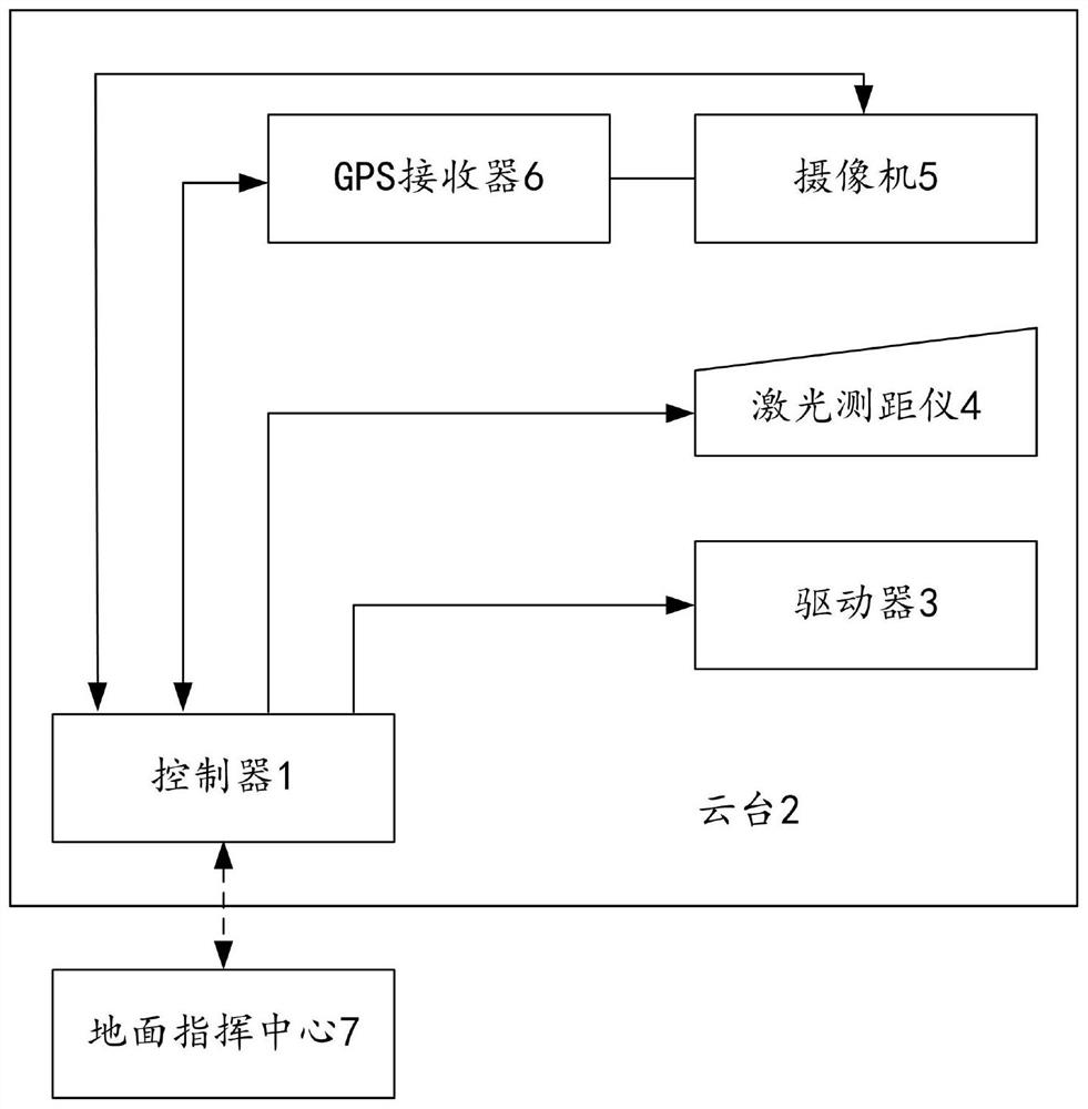
[0051] Such as figure 1 As shown, a fire point location correction system based on laser ranging and GIS map of the present invention can realize fast, accurate and automatic fire point location correction.

[0052] The system mainly includes the following components:

[0053] Controller 1, pan / tilt 2, driver 3, laser range finder 4, camera 5 and GPS receiver 6.

[0054] The controller 1 can communicate with the ground command center 7 wirelessly, and receive and execute control instructions from the ground command center 7 .

[0055] The driver 3 , the laser rangefinder 4 , the camera 5 and the GPS receiver 6 are all electrically connected to the controller 1 .

[0056] Controller 1, laser rangefinder 4 and video camera 5 are all installed on the monitoring ball table of cloud platform 2.

[0057] GPS receiver 6 is electrically connected with video camera 5, and GPS receiver 6 is installed on the optical axis of video camera 5;

[0058] The gimbal 2 has its own driver 3 f...


PUM


Abstract

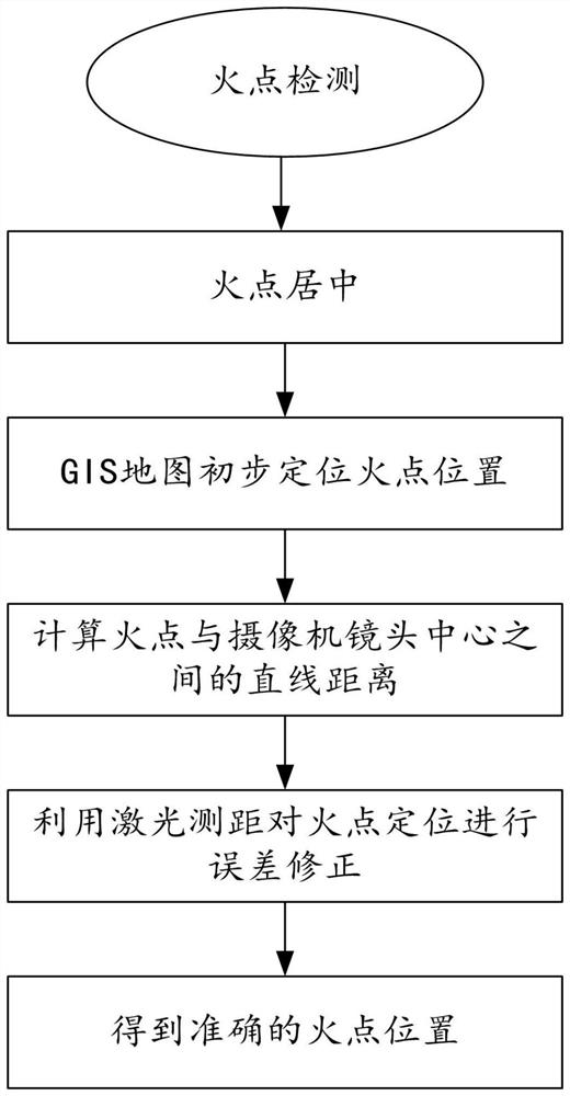
The invention discloses a fire point positioning correction method based on laser ranging and a GIS map, and relates to the field of fire point positioning. The fire point is centered; a GIS map preliminarily locates the position of a fire point; calculating the linear distance between the fire point and the center of the camera lens; the laser range finder is used for correcting the error of the fire point position; and calculating the corrected accurate fire point position. According to the method, rapid, accurate and automatic fire point positioning correction can be achieved, the defects of an existing fire point positioning method are overcome, real-time calculation can be completed, the whole fire point positioning process can be automatically and rapidly completed, and deep dependence on past experience of forest rangers is not needed any more; meanwhile, fire point positioning is carried out based on an accurately drawn GIS map, high-precision error correction is carried out on the fire point by using a laser range finder, accurate fire point position information is finally obtained, accurate fire point positioning can be timely and rapidly provided for fire fighting and fire extinguishing tasks, and the method is suitable for wide popularization and application.

Description

technical field [0001] The invention relates to the technical field of fire point positioning, in particular to a fire point positioning correction method based on laser ranging and GIS maps. Background technique [0002] There are two main causes of forest fires, one is man-made fire, and the other is natural fire. Man-made fires mainly include: productive fire sources, non-productive fire sources and intentional arson. Among the fires caused by man-made fire sources, forest fires caused by land reclamation, smoking, and paper burning are the most. Forest fires can have devastating consequences for forests. Forest fires will not only burn patches of forest and harm animals in the forest, but also reduce forest regeneration capacity, cause soil barrenness, and destroy forest water conservation. The ecological environment is out of balance. Specific losses caused by forest fires include: [0003] 1. Loss of forest resources [0004] Forest resource loss is the most impor...

Claims


Application Information

Patent Timeline
IPC IPC(8): G06F16/29G06F17/11G01S17/08
Inventor 蔡宇左春婷王金龙黄艳金
Owner CHINA FORESTRY STAR BEIJING TECH INFORMATION CO LTD
Learn More