Method and system for positioning and correcting video data by using submarine topography profile

A terrain profile and data positioning technology, which is applied to instruments, character and pattern recognition, computer components, etc., can solve the problems of incompatibility between video data and actual geographic location, low accuracy, and bending of sound rays

Pending Publication Date: 2022-04-08
THE FIRST INST OF OCEANOGRAPHY SOA +1
View PDF0 Cites 0 Cited by
  • Summary
  • Abstract
  • Description
  • Claims
  • Application Information

AI Technical Summary

Problems solved by technology

[0004] (1) Due to the influence of factors such as dynamic changes in the marine environment, installation and calibration deviations of measuring instruments, measurement reliability of peripheral equipment, and accuracy of sound velocity measurement and correction, there will be large gross errors and continuous abnormal errors in ultra-short baseline positioning
[0005] (2) Since the ultra-short baseline positioning system is a kind of underwater acoustic positioning technology, for the underwater acoustic positioning system, the uneven distribution of underwater sound velocity will cause sound rays to bend, which will seriously affect the positioning accuracy of the system
[0006] (3) The data obtained through the ultra-short baseline positioning system will have a large number of error points and outliers, which will cause information misalignment in both time and space scales of the positioning data, and even some survey lines cannot find any information that can pass through. The method of processing the ultra-short baseline data itself to achieve positioning makes the surveyed video data unable to correspond to the actual geographical location, that is, it is impossible to accurately locate the sulfide mineral spots obtained through video, which seriously affects the use and analysis of video data Research
[0007] To sum up, at present, there are problems such as low precision and low accuracy in the positioning of seabed video data using ultra-short baselines. How to overcome the above problems has become a technical problem that needs to be solved urgently in this field.

Method used


Image

  • Method and system for positioning and correcting video data by using submarine topography profile
  • Method and system for positioning and correcting video data by using submarine topography profile
  • Method and system for positioning and correcting video data by using submarine topography profile

Examples


Embodiment 1

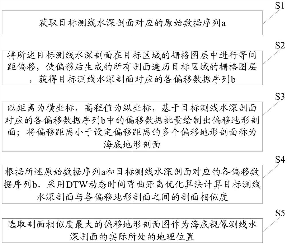
[0070] Such as figure 1 As shown, the present invention discloses a method for positioning and correcting video data using a seabed terrain profile, the method comprising:

[0071] Step S1: Obtain the original data sequence a corresponding to the sounding profile of the target survey line.

[0072] Step S2: Migrate the sounding profile of the target survey line at equal intervals in the grid layer of the target area, so that all profiles generated after migration traverse the grid layer of the target area, and obtain the corresponding depth profile of the target survey line Each offset data sequence b.

[0073] Step S3: Taking the distance as the abscissa and the elevation as the ordinate, based on the offset data in each offset data sequence b corresponding to the water depth profile of the target survey line, the offset topographic profile is drawn in batches; the offset distance is less than the set offset A plurality of offset topographic profiles that shift distances is...

Embodiment 2

[0108] Such as Figure 4 As shown, the present invention is also a system for positioning and correcting video data using a seabed topographic profile, said system comprising:

[0109] The obtaining module 401 is used to obtain the original data sequence a corresponding to the sounding profile of the target survey line.

[0110] The offset module 402 is used to offset the sounding profile of the target survey line at equal intervals in the grid layer of the target area, so that all profiles generated after the offset traverse the grid layer of the target area to obtain the target survey line. Each offset data sequence b corresponding to the line water depth profile.

[0111] The drawing module 403 is used for taking the distance as the abscissa and the elevation value as the ordinate, and based on the offset data in each offset data sequence b corresponding to the target survey line water depth profile, the offset terrain profile is drawn in batches; the offset distance is le...

Embodiment 3

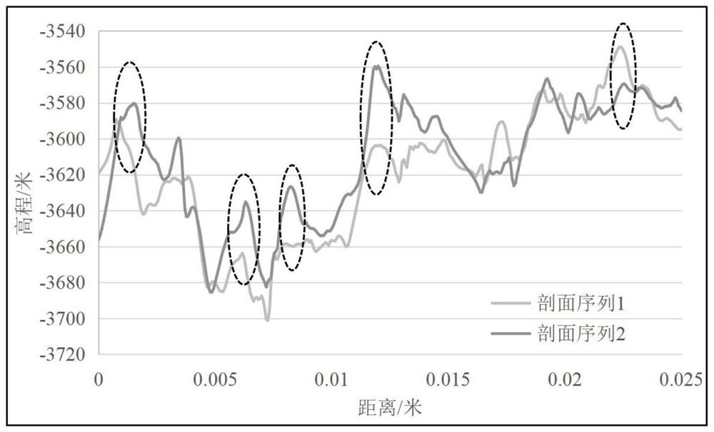
[0123] Before performing positioning correction on the seabed video depth profile, first check the properties of the original data. Such as Figure 5 As shown, the original data (AUV high-precision terrain data of the research area) tag20marea used in the present invention has a data accuracy of 1m×1m, a GRID grid format, and a data range of 26.1788306731~26.1291175383, -44.834999084~-44.799911499, and the spatial reference coordinates System GCS_WGS_1984, datum D_WGS_1984. The data line of the target line element (the sounding profile of the target survey line) ranges from 26.170278 to 26.164633, -44.829083 to -44.824617, the spatial data type of Shapefile, the geographic coordinate system GCS_WGS_1984, and the datum D_WGS_1984.

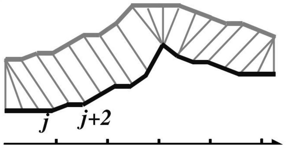
[0124] Step S1: In the research target area tag20marea, the target line element line is offset in batches at an average interval of 10 meters from east to west, south to north, such as Figure 6 As shown, (a) is a schematic diagram of the profile ...


PUM


Abstract

The invention relates to a method and a system for positioning and correcting video data by using a submarine topography profile. The method comprises the following steps of: performing equal-interval offset on a target survey line water depth profile in a grid layer of a target area to obtain each offset data sequence corresponding to the target survey line water depth profile; based on offset data in each offset data sequence corresponding to the target survey line water depth profile, drawing offset terrain profiles in batches; according to the original data sequence and each offset data sequence, a DTW dynamic time bending distance optimization algorithm is adopted to calculate the section similarity between the target survey line water depth section and each offset terrain section; and selecting the geographic position of the offset terrain profile map with the maximum profile similarity as the actual geographic position of the submarine video survey line water depth profile. According to the method, the terrain profile with the highest similarity with the water depth profile of the target measuring line can be quickly and accurately matched in the target area without using an ultra-short baseline positioning system, and the purpose of positioning and correcting the submarine video data is achieved.

Description

technical field [0001] The invention relates to the technical field of application of seabed solid mineral resources, in particular to a method and system for positioning and correcting video data by using seabed terrain profiles. Background technique [0002] Near-bottom camera is one of the most effective detection methods for seabed hydrothermal sulfide resource investigation, and the accuracy of seabed camera data positioning is the basis for further in-depth sulfide investigation and research. The near-bottom camera data is generally collected by the camera towed body towed by the ship near the seabed, and the positioning of the camera equipment is generally realized by means of an ultra-short baseline fixed on the near-bottom equipment. The ultra-short baseline measurement accuracy is high, but due to the measurement environment and other reasons, it will cause different degrees of false data, wrong data, or even missing data, which will bring difficulties to camera po...

Claims


Application Information

Patent Timeline
Patent Type & Authority Applications(China)
IPC IPC(8): G06V10/24G06K9/62G06V10/74
CPCG01V1/38G01V1/305G01V2210/6222G01V1/3817G06F18/22G01V1/3808
Inventor 闫仕娟时欣宇李传顺赵越杨刚叶俊赵秋魁石丰登杜德文朱志伟
Owner THE FIRST INST OF OCEANOGRAPHY SOA
Why Eureka
Try Eureka