Sky-ground integrated monitoring method for monitoring pine wood nematode disease

A technology for pine wood nematode disease and sky-ground, which is applied in the direction of instruments, character and pattern recognition, scene recognition, etc., can solve the problem that no application technology system has been formed, the advantages of satellite remote sensing and UAV remote sensing have not been fully utilized, and single technology utilization Level and other issues, to achieve the effect of taking into account efficiency and cost, high efficiency, and fast access to information

Pending Publication Date: 2022-04-22
浙江同创空间技术有限公司
View PDF0 Cites 9 Cited by
  • Summary
  • Abstract
  • Description
  • Claims
  • Application Information

AI Technical Summary

Problems solved by technology

However, these methods are still at the level of single technology utilization at the practical level. The respective advantages of satellite remote sensing and UAV remote

Method used


Image

  • Sky-ground integrated monitoring method for monitoring pine wood nematode disease
  • Sky-ground integrated monitoring method for monitoring pine wood nematode disease
  • Sky-ground integrated monitoring method for monitoring pine wood nematode disease

Examples


Embodiment 1

[0063] Such as Figure 1-9 Described pine wood nematode disease monitoring air-ground integrated monitoring method, comprises the following steps:

[0064] S1. Select the location of the area. First, extract the diseased and dead trees through drone images, extract the diseased and dead tree patches through satellite images, and conduct on-the-spot marking, positioning and measurement of the dead trees through ground surveys;

[0065] S2. Obtain high-spatial resolution satellite remote sensing data and UAV remote sensing data as data sources, combine ground survey data and forest resources second-class survey data to jointly form a data set for the monitoring area;

[0066] High spatial resolution satellite remote sensing data include 50cm spatial resolution panchromatic band (470-830nm) data and 2m spatial resolution blue, green, red, near-infrared four-band multispectral data.

[0067] The relevant technical parameters of high spatial resolution satellite remote sensing dat...

Embodiment 2

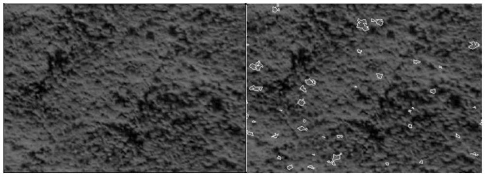
[0158]In this embodiment two, in the pine forest subcompartment, check the forest coverage situation from the satellite remote sensing image, and can find that there are some areas not covered by forest trees in the subcompartment area, such as open space in the forest, wasteland and forest edge bare land. The spectral characteristics are very similar to those of the diseased wood. In order to reduce the interference of these ground features on the extraction of the diseased wood, the second embodiment will further eliminate these non-forest covered areas. Object-oriented and random forest classification methods are used to classify the images of the pine forest subcompartment, and the forest coverage area is distinguished from wasteland, forest edge bare land, etc., so as to eliminate the non-forest areas in the pine forest subcompartment, which is for the accurate extraction of diseased trees. Interference factors; the random forest model is a new type of machine learning alg...

Embodiment 3

[0160] The experimental results of the 2020 general survey of pine wood nematodes in Jindong District of Jinhua City and Yongkang City of Jinhua City were selected using this method.

[0161] Firstly, Jindong District of Jinhua City covers an area of ​​658.19Km2, and Yongkang City of Jinhua City covers an area of ​​1049Km2. Both areas use aerial photography to obtain remote sensing images. The video was taken on October 31, 2020. The spatial resolution of aerial images is 0.5 meters, including four bands of red, green, blue and near-infrared. The results of the census are shown in the table below.

[0162]

[0163]

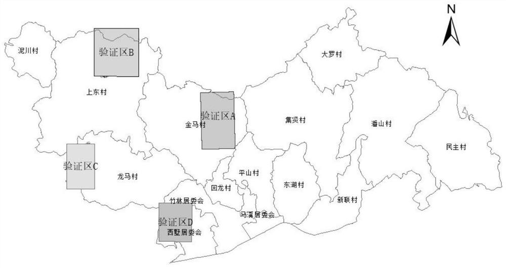
[0164] The second step is to verify the identification results of Jindong District.

[0165] Jindong District selected Jiangdong, Lingxia, Yuandong, and Chisong townships as samples, and verified the census data based on the air-space-ground integration method with the actual number of infected trees harvested in the process of eradicating the region, and ...


PUM


Abstract

According to the technical scheme, the sky-ground integrated monitoring method comprises the steps that S1, firstly, infected and withered trees are extracted through unmanned aerial vehicle images, plaques of the infected and withered trees are extracted through satellite images, and on-site marking, positioning and measuring are conducted on the withered trees through ground investigation; s2, respectively acquiring high-spatial-resolution satellite remote sensing data and unmanned aerial vehicle remote sensing data as data sources, and jointly forming a data set of a monitoring area in combination with ground survey data and forest resource second-class survey data; s3, establishing samples of the epidemic trees according to the data, wherein the samples comprise spectral features, texture features and geometric features of the pine wood nematode disease withered and dead trees; and S4, according to the sample and satellite remote sensing, confirming the infected, withered and dead tree plaques, comprehensively applying an image enhancement and image classification method, performing verification, and establishing spatial distribution information and position information of the pine wood nematode disease withered and dead trees. The method has the advantages of high epidemic area screening efficiency, capability of realizing large-area efficient monitoring, convenience in acquisition of remote sensing data of the unmanned aerial vehicle, high recognition precision and guarantee for precision verification.

Description

technical field [0001] The invention relates to the technical field of pine wood nematode research, in particular to a sky-ground integrated monitoring method for monitoring pine wood nematode disease. Background technique [0002] Pine xylophilus is the most serious and devastating alien invasive species of pine trees. It can cause the death of pine trees within about 40 days at the earliest after being infected, and all die within 2-3 months. Since its first discovery in my country in 1982, it has spread rapidly. In March 2021, it has spread to 723 county-level administrative regions in 17 provinces (cities, autonomous regions) across the country, including 70 counties (cities, districts) in Zhejiang Province. , the situation of prevention and control is very severe. [0003] Active prevention and control efforts with increasing investment and increasingly strict measures have failed to completely block the spread of the epidemic. The most important reason is the lack of t...

Claims


Application Information

Patent Timeline
IPC IPC(8): G06V20/13G06V20/17G06V10/58G06V10/22G06V10/56G06V10/26G06V10/776G06K9/62
CPCG06F18/2193
Inventor 陈小华吴利平丁丽霞李伟明茹磊季卓周通
Owner 浙江同创空间技术有限公司
Why Eureka
Try Eureka