Landslide disaster monitoring equipment deployed by unmanned aerial vehicle and self-adaptive fixing method of landslide disaster monitoring equipment
A technology of monitoring equipment and unmanned aerial vehicles, applied in climate change adaptation, radio wave measurement system, satellite radio beacon positioning system, etc., can solve the problems of easy rollover of monitoring equipment deployment and easy tilt of satellite antenna, etc., and achieve stability Transport and ensure the effect of correct orientation
- Summary
- Abstract
- Description
- Claims
- Application Information
AI Technical Summary
Problems solved by technology
Method used
Image
Examples
Embodiment 1
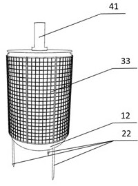
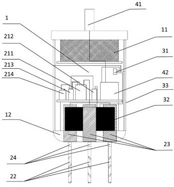
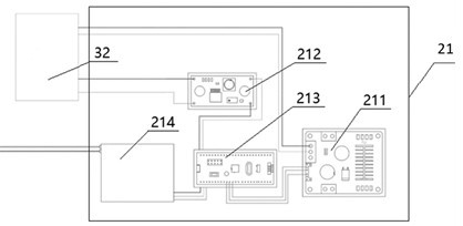
[0046] This embodiment is a landslide disaster monitoring device deployed by an unmanned aerial vehicle, such as figure 1 , figure 2 , Image 6 shown, including:
[0047] A remote control for remote monitoring of the deployment of the cabinet 1,
[0048] Monitoring box 1 for arranging each functional module, monitoring box 1 is a hollow cylinder, and the specific dimensions are: the bottom surface diameter is 250mm, and the height is 300mm. Impact damage to prevent rainwater from entering. A circular arc-shaped streamline cover 12 is arranged under the monitoring box 1 to reduce the influence of air resistance during the drop of the equipment and avoid the equipment from rolling over. The upper part of the monitoring box 1 is provided with The buffer protection layer 11 can slow down the equipment from being damaged by external force during the placing and fixing process. The monitoring box 1 is provided with:
[0049] A monitoring system 4 for receiving GNSS satellite data...
Embodiment 2
[0060] This embodiment is an adaptive fixing method for a landslide disaster monitoring device deployed by an unmanned aerial vehicle based on the new landslide disaster monitoring device in Example 1, such as Figure 7 shown, including the following steps:
[0061] S1. Connect the monitoring box 1 with the delivery mechanism 5, engage the lock 58 on the stable platform 54 with the groove on the monitoring box 1, and then connect the stable platform 54 with the steering gear 52 through the rocker arm 53 and the steering gear 52. The fixed surface 51 of the delivery mechanism is fixed, and finally the fixed surface 51 of the delivery mechanism is directly fixedly connected to the drone, thereby realizing the fixation between the landslide disaster monitoring equipment and the drone;
[0062] S2. The remote control controls the flight of the UAV fixed with the landslide disaster monitoring equipment. During the flight, the steering gear 52 is used to control the lifting and fall...
Embodiment 3
[0067] The difference between this embodiment and Embodiment 2 is:
[0068] In step S3, the drone flies to 2m above the pre-selected monitoring point and hovers.
PUM
 Abstract
Description
Claims
Application Information
 - R&D
- Intellectual Property
- Life Sciences
- Materials
- Tech Scout
- Unparalleled Data Quality
- Higher Quality Content
- 60% Fewer Hallucinations
Browse by: Latest US Patents, China's latest patents, Technical Efficacy Thesaurus, Application Domain, Technology Topic, Popular Technical Reports.
© 2025 PatSnap. All rights reserved.Legal|Privacy policy|Modern Slavery Act Transparency Statement|Sitemap|About US| Contact US: help@patsnap.com


