Planning and control method for landing of unmanned aerial vehicle in crosswind environment

A control method and unmanned aerial vehicle technology, applied in the field of unmanned aerial vehicles, can solve the problem that the sideslip angle cannot be reduced, and achieve the effect of strong flexibility

Pending Publication Date: 2022-06-28
CHENGDU AIRCRAFT INDUSTRY GROUP +1
View PDF0 Cites 1 Cited by
  • Summary
  • Abstract
  • Description
  • Claims
  • Application Information

AI Technical Summary

Problems solved by technology

In this way, it can ensure that the lateral deviation will not be too large when touching down, and the heading deviation will not be too large, but the sideslip angle at the moment of landing and touching down cannot be reduced.
Moreover, in actual implementation, when to switch from the "side navigation method" to the "side slip method" is also determined artificially based on experience, and whether the switching time is reasonable, there is no standard and basis for judging before the final landing

Method used


Image

  • Planning and control method for landing of unmanned aerial vehicle in crosswind environment
  • Planning and control method for landing of unmanned aerial vehicle in crosswind environment
  • Planning and control method for landing of unmanned aerial vehicle in crosswind environment

Examples


Embodiment 1

[0049] A method for planning and controlling UAV landing in a crosswind environment according to this embodiment, comprising:

[0050] Step S1. Collect the parameters of the lateral and yaw motion state of the aircraft, the parameters of the longitudinal motion state, and the environmental parameters through the airborne sensors;

[0051] Step S2. Predict the landing time of the aircraft according to the data collected by the airborne sensors, and judge the start time of trajectory planning;

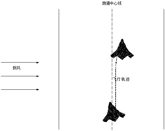
[0052] Step S3. Taking the UAV’s lateral deviation distance, lateral deviation speed, roll angle, and heading angle at the beginning of trajectory planning as the initial planning parameters, determine the aircraft’s terminal state constraint parameters according to the aircraft’s use restrictions, and combine the aircraft’s current wind speed and Wind direction, using the MPC planning algorithm to plan the lateral flight trajectory of the UAV;

[0053] Step S4. Use the planning result ...

Embodiment 2

[0057] This embodiment is further optimized on the basis of Embodiment 1. In this embodiment, the parameters obtained by the airborne sensor are used as the input of the crosswind landing plan of the UAV, and the lateral motion parameters and the longitudinal motion parameters of the aircraft motion collected by the airborne sensor, Rely on weather radar acquisition or airborne sensor parameters to solve environmental parameters. It can better deal with the situation of strong cross wind.

[0058] Other parts of this embodiment are the same as those of Embodiment 1, so details are not repeated here.

Embodiment 3

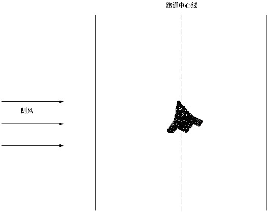
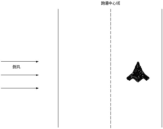
[0060] This embodiment is further optimized on the basis of the above-mentioned embodiment 1 or 2. In this embodiment, the motion parameters can be obtained according to the on-board sensors, and the wind speed and wind direction can be obtained by weather radar or according to the parameters measured by the sensors through an algorithm. Calculation methods commonly used by those skilled in the art. When the aircraft is descending, use the integrated navigation system sensor to measure and record the lateral movement parameters, these parameters include: lateral deviation distance from the runway center line, lateral deviation speed, yaw angle and roll angle; radio altimeter, air data The system or satellite navigation system measures and records the longitudinal motion parameters of the aircraft. The longitudinal motion parameters of the aircraft include the height of the aircraft and the sinking rate of the aircraft. The data measured by weather radar or based on the inertial...


PUM


Abstract

The invention relates to the technical field of unmanned aerial vehicles, and discloses a planning and control method for landing of an unmanned aerial vehicle in a crosswind environment, which comprises the following steps: S1, acquiring parameters of a lateral course motion state, parameters of a longitudinal motion state and environmental parameters of the aircraft through an airborne sensor; s2, predicting the landing time of the aircraft according to the data collected by the airborne sensor, and judging the starting time of trajectory planning; s3, the lateral deviation distance, the lateral deviation speed, the roll angle and the course angle of the unmanned aerial vehicle at the beginning of trajectory planning serve as initial planning parameters, terminal state constraint parameters of the aircraft are determined according to aircraft use limitation, and the transverse and lateral flight trajectory of the unmanned aerial vehicle is planned by adopting an MPC planning algorithm in combination with the current wind speed and wind direction of the aircraft; and S4, taking the planning result as an instruction of a transverse course trajectory tracking and attitude controller, and designing a corresponding controller algorithm to track a reference instruction generated by planning. According to the invention, a proper control law is designed to track a generated flight state trajectory instruction.

Description

technical field [0001] The invention relates to the technical field of unmanned aerial vehicles, specifically, a planning and control method for unmanned aerial vehicle landing in a crosswind environment, which is used to plan the aircraft before landing according to the state constraints at the moment of landing by using the optimal planning method. The flight state trajectory command is designed, and an appropriate control law is designed to track the generated flight state trajectory command. Background technique [0002] With the development of aviation technology, drones are used more and more in various occasions, and the requirements for the use environment are becoming more and more stringent. During the landing process of the wheeled take-off and landing UAV, because it works in an environment with low airspeed, low speed pressure and high angle of attack, it will be more sensitive to the influence of external wind disturbance. During the landing phase, the crosswi...

Claims


Application Information

Patent Timeline
Patent Type & Authority Applications(China)
IPC IPC(8): G05D1/08G05D1/10
CPCG05D1/0808G05D1/101
Inventor 崔庆梁余长贵刘宇佳张瞿辉黄捷马松辉邵朋院
Owner CHENGDU AIRCRAFT INDUSTRY GROUP
Why Eureka
Try Eureka