Clustering method for objects in aerial image of unmanned aerial vehicle

A clustering method and technology in images, applied in the field of image processing, to achieve clear semantics, avoid excessive clustering with high image density, and improve clustering accuracy

Pending Publication Date: 2022-07-12
ZHEJIANG UNIV OF TECH
View PDF0 Cites 0 Cited by
  • Summary
  • Abstract
  • Description
  • Claims
  • Application Information

AI Technical Summary

Problems solved by technology

At present, it is relatively easy to mark a specific target object in a single aerial image by means of deep learning or manual methods, but the same object often shows great differences in different images due to factors such as different shooting attitudes, angles, and occlusions. The determination of the same object in different aerial images still needs an effective clustering method

Method used


Image

  • Clustering method for objects in aerial image of unmanned aerial vehicle
  • Clustering method for objects in aerial image of unmanned aerial vehicle
  • Clustering method for objects in aerial image of unmanned aerial vehicle

Examples


Embodiment Construction

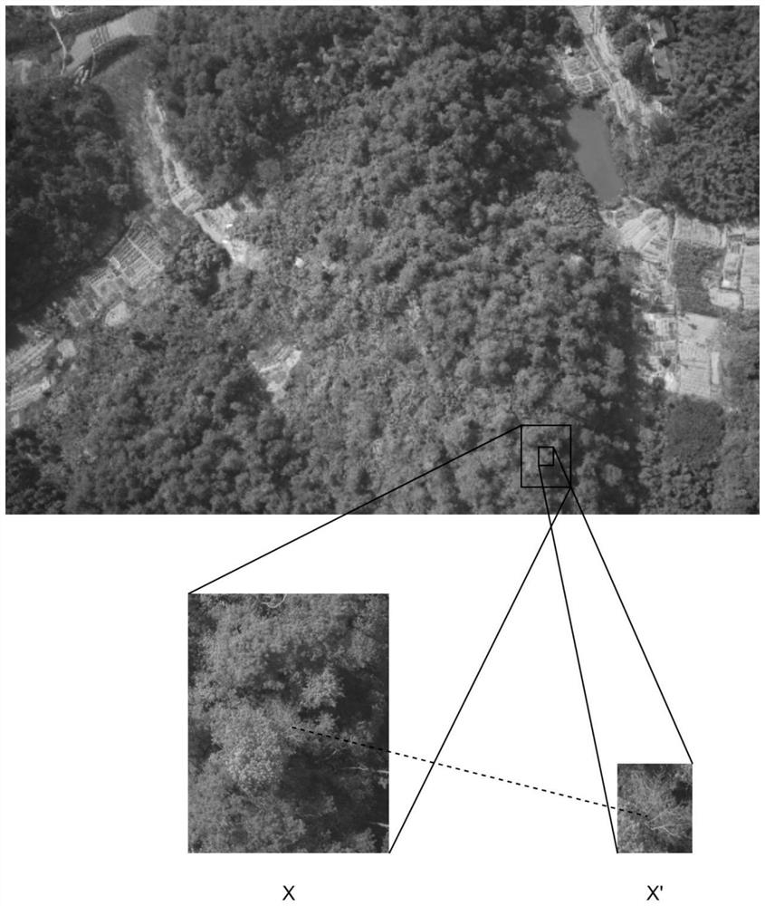
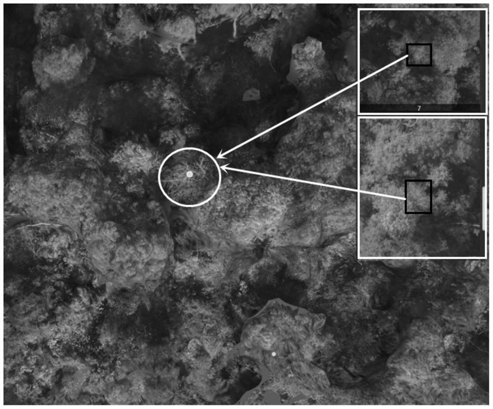
[0030] With reference to the accompanying drawings, the present invention is further described by taking the clustering of dying wood or dead wood of pine trees as an example in the aerial image:

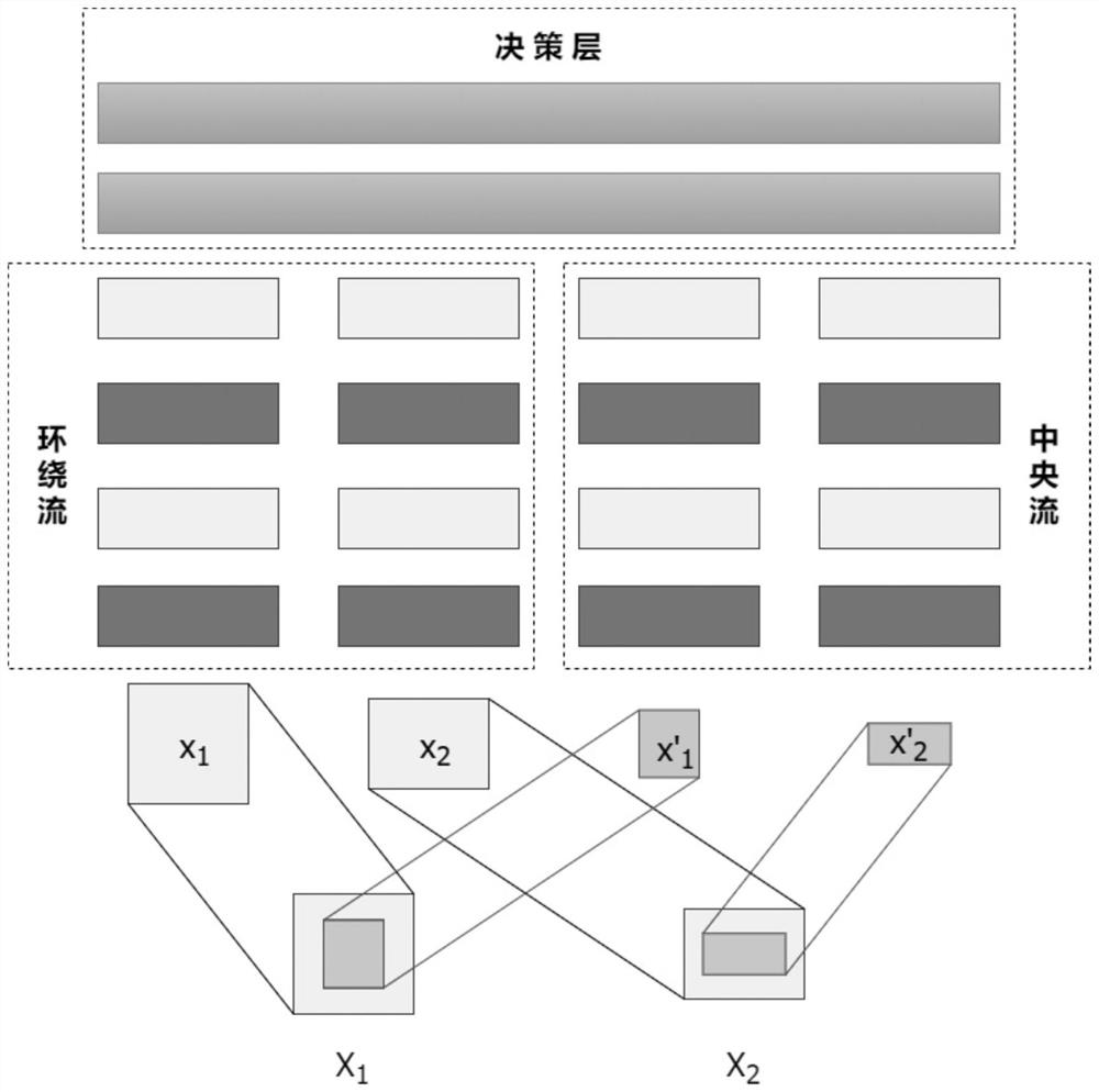
[0031] The clustering method of objects in UAV aerial images uses deep learning-based target detection algorithms such as YOLO to identify specific targets in aerial images, calculates the image similarity of the small image where the objects are located through the twin neural network, and combines Based on the difference of latitude and longitude coordinates, calculate whether the two images are reachable by distance, and divide all images into several sets with no repeating elements and reachable distances between elements in the set according to the distance reachability between the images.

[0032] In this example, the aerial photo of the drone is taken by oblique photography and five-line flight. The shooting set the heading overlap of 80% and the side overlap of 70%. The ident...


PUM


Abstract

A clustering method for objects in an aerial image of an unmanned aerial vehicle can cluster the objects existing in the multi-view aerial image, enables semantics of a target detection result to be clearer, solves the problem that an image result cannot be mapped to an actual object in unmanned aerial vehicle inspection, and comprises the following steps: (1) according to a mark box of the object in the image, obtaining a target object; cutting out a large sub-graph and a small sub-graph; (2) respectively pairing each group of sub-graphs as the input of the middle-loop double-flow twin neural network; (3) calculating a similarity distance through the output of the neural network and the longitude and latitude coordinates of the object in the center of the corresponding sub-graph, and considering that the distance is reachable for the image pair with the similarity distance smaller than a threshold value; and (4) transmitting distance reachability to obtain an image set with mutual distance reachability of internal elements, and taking the image set as a clustering result. The method has the following advantages: the method is high in universality; the accuracy is high; the calculation efficiency is high; the result is simple.

Description

technical field [0001] The invention belongs to the field of image processing, and relates to a method for clustering objects in multi-view images. Background technique [0002] UAV is a remote sensing platform that is easy to operate and easy to transition. UAV aerial imagery has the advantages of high definition, large scale, small area and high current situation. It is widely used in national ecological environmental protection, mineral resource exploration, marine environment monitoring, land use survey, water resources development, crop growth monitoring and Production estimation, agricultural operations, natural disaster monitoring and evaluation, urban planning and municipal management, forest pest protection and monitoring, digital earth and other fields. Especially in the field of inspection, the inspection model of drones and drone nests is gradually being promoted. [0003] Usually drone aerial images have a certain degree of overlap, and the target object will ...

Claims


Application Information

Patent Timeline
Patent Type & Authority Applications(China)
IPC IPC(8): G06V20/17G06V10/762G06V10/74G06K9/62G06V10/82G06N3/04G06N3/08
CPCG06N3/08G06N3/045G06F18/23G06F18/22
Inventor 金灵枫陈佳舟李硕文徐阳辉
Owner ZHEJIANG UNIV OF TECH
Why Eureka
Try Eureka