Self-contained assistant navigation and position method of a GPS receiving device

A technology for auxiliary navigation and receiving devices, applied in the field of land navigation, can solve the problems of difficult cost control and unfavorable implementation, and achieve the effects of low cost, simple positioning and high precision

Inactive Publication Date: 2005-03-16
河南紫辰科技发展有限公司
View PDF0 Cites 19 Cited by
  • Summary
  • Abstract
  • Description
  • Claims
  • Application Information

AI Technical Summary

Problems solved by technology

Wireless ranging assisted positioning requires the installation of wireless transmitting equipment in a large area in known GPS blind areas, and its cost is difficult to control, and it is not conducive to implementation outside urban areas such as mountainous areas

Method used


Image

  • Self-contained assistant navigation and position method of a GPS receiving device

Examples


Embodiment Construction

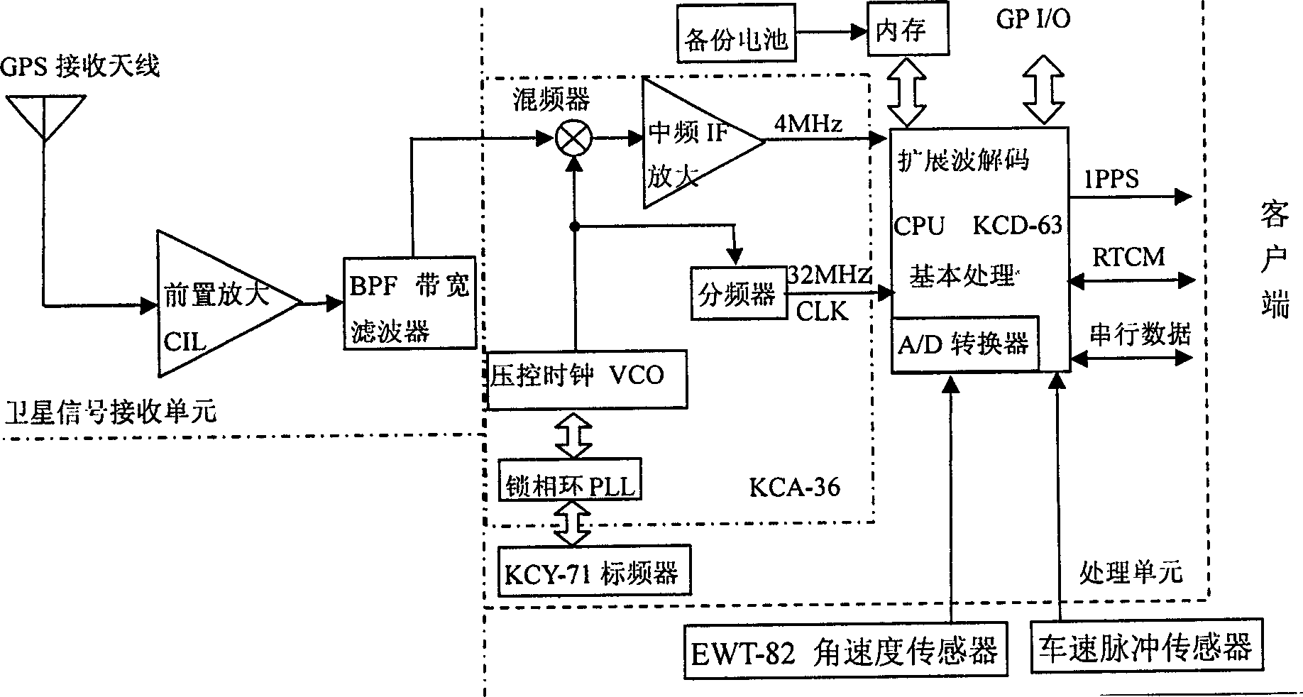
[0013] like figure 1 As shown, the self-discipline assisted navigation positioning method of the present invention is specifically as follows:

[0014] Step 1: After the GPS antenna receives the signal, the preamplifier CIL selectively amplifies the 1575.42±1MHz signal. After the signal is filtered by the bandwidth filter BPF, it is spread by the pseudo-random code spread spectrum demodulator (KCA-36). After frequency demodulation, the microprocessor CPU (KCD-63) performs decoding operation, and the processed data is output with TTL level.

[0015] Step 2: The pseudo-random code spread spectrum demodulator (KCA-36) is connected to the standard frequency converter KCY-71. After decoding, the CPU judges whether the number of satellites that can receive signals and the signal strength meet the positioning requirements. It is used for the first time. When the device is installed, it is required to initialize first after installing the device in order to obtain and save the pulse ...


PUM


Abstract

This invention relates to self-discipline assisted navigation location method of the GPS receiving apparatus which can realize the location continuity of the GPS satellite signal blind area and enlarge the GPS utility range and the GPS performance to cost ratio. The method is the following: to base on the data before signal interval and to calculate the operation speed and operation direction and to output the two-dimension location information; the GPS antenna receives the signals which are amplified, filtered, expand demodulated, CPU demode calculation; the CPU after demode judges the signal satellite amount and judges whether the signal intensity meets the location requirements. If the GPS cannot locate, then it will be automatically switched into the self-discipline navigation status and get the mobile direction through the angle sensor integral operation and get the distance through the calculation of the impulse signals of the speed sensor.

Description

technical field [0001] The invention belongs to the technical field of land navigation, and in particular relates to a self-discipline of a GPS receiving device which can realize positioning continuity in GPS satellite signal blind areas such as urban building areas, under viaducts and culvert tunnels, and improve the application range of GPS and the performance-price ratio of GPS equipment Auxiliary navigation positioning method. Background technique [0002] At present, the GPS navigation devices widely used in our country rely entirely on GPS satellite signals. Under the influence of many factors such as the rapid development of urban three-dimensional traffic and the rapid development of high-rise buildings, many GPS signal blind spots have been formed. In this case, GPS receivers cannot position. Therefore, there is an urgent need for a method that can assist positioning in blind spots to ensure the continuity of navigation. At present, the methods that can realize as...

Claims


Application Information

Patent Timeline
Patent Type & Authority Applications(China)
IPC IPC(8): G01C21/26G01S19/26
Inventor 吴晓北陈亨刘五一
Owner 河南紫辰科技发展有限公司
Why Eureka
Try Eureka