Three-dimensional cartographic user interface system

a user interface and cartographic technology, applied in the field of cartography, can solve the problems of significantly inhibiting geo-spatial comprehension and being unsuitable, and achieve the effect of facilitating user interaction

Inactive Publication Date: 2006-04-06
SOLID TERRAIN MODELING
View PDF5 Cites 73 Cited by
  • Summary
  • Abstract
  • Description
  • Claims
  • Application Information

AI Technical Summary

Benefits of technology

[0014] The present invention also addresses the shortcomings of the prior art by providing a 3D-CUI system comprising a highly accurate, 3D topographical surface representing a geographical area, which is contiguously shaped having a true-to-nature appearance with a realistic 3D scale. Alternatively, the 3D-CUI can have a requested scale exaggeration, for example, to exaggerate elevation changes in a map's topography. In either case, an uninterrupted contiguously shaped surface of the 3D-CUI, whether representing elevation changes accurately, or with scale exaggeration, provides for the sliding, or easy positioning, of one or more input devices accurately, at precise locations on, or over one or more areas of, the 3D cartographic surface. Thus, one or more users can be interactively engaged with the 3D-CUI of the system at a time, by controlling switchable and/or variable software routines or parameters from one

Problems solved by technology

In the past, the prior art attempted to convey three dimensional cartographic information either with (a) two dimensional maps, or (b) crudely made, ‘cut-out’ or stair-step-layered topographical maps that were not suited to having accurate and properly registered high resolution printing done on them.
While the stair-step-layered appearance of 3D map renderings facilitated a better comprehension of 3D topography, they were not suited, due to their jagged pr

Method used


Image

  • Three-dimensional cartographic user interface system
  • Three-dimensional cartographic user interface system
  • Three-dimensional cartographic user interface system

Examples


Embodiment Construction

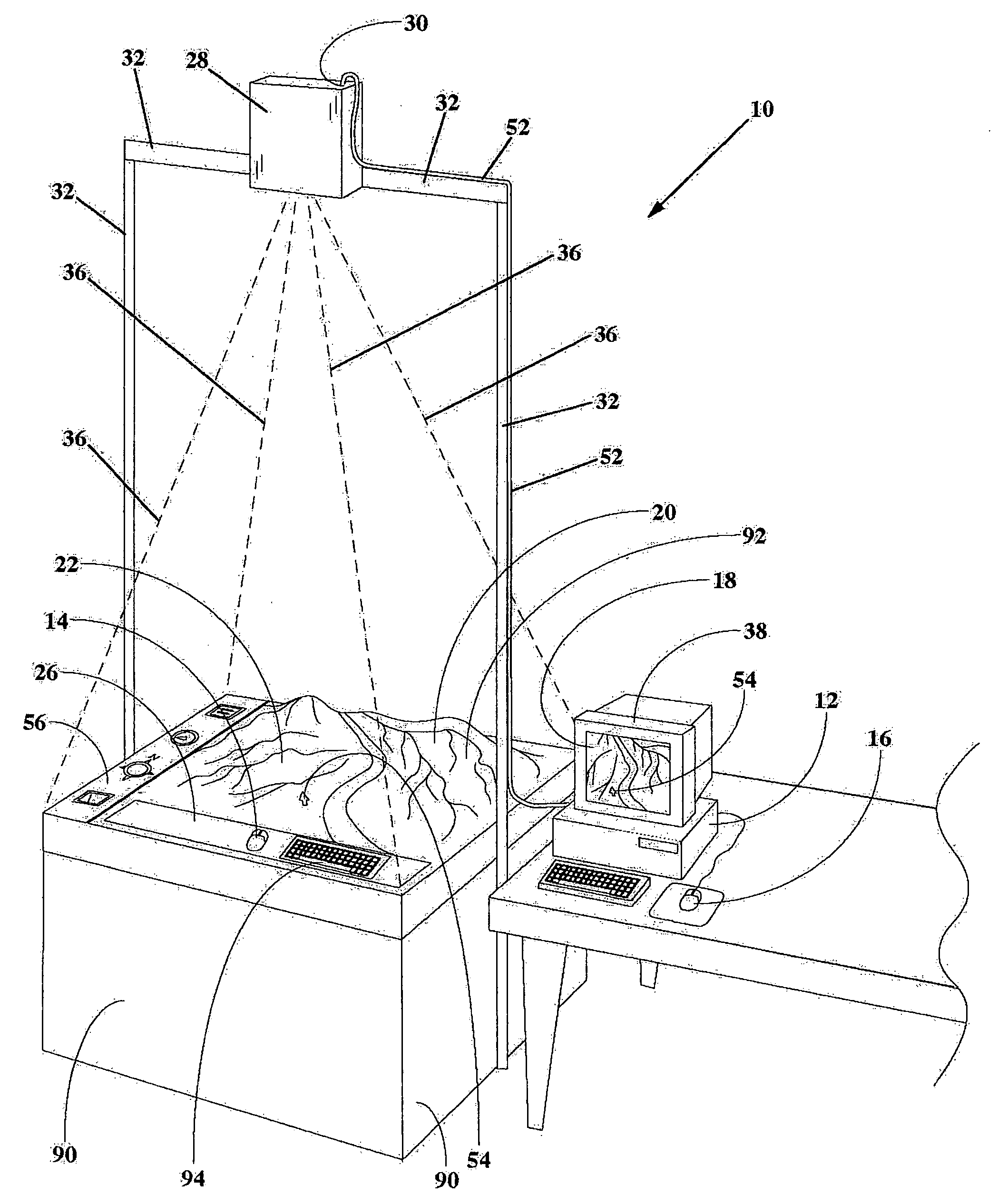
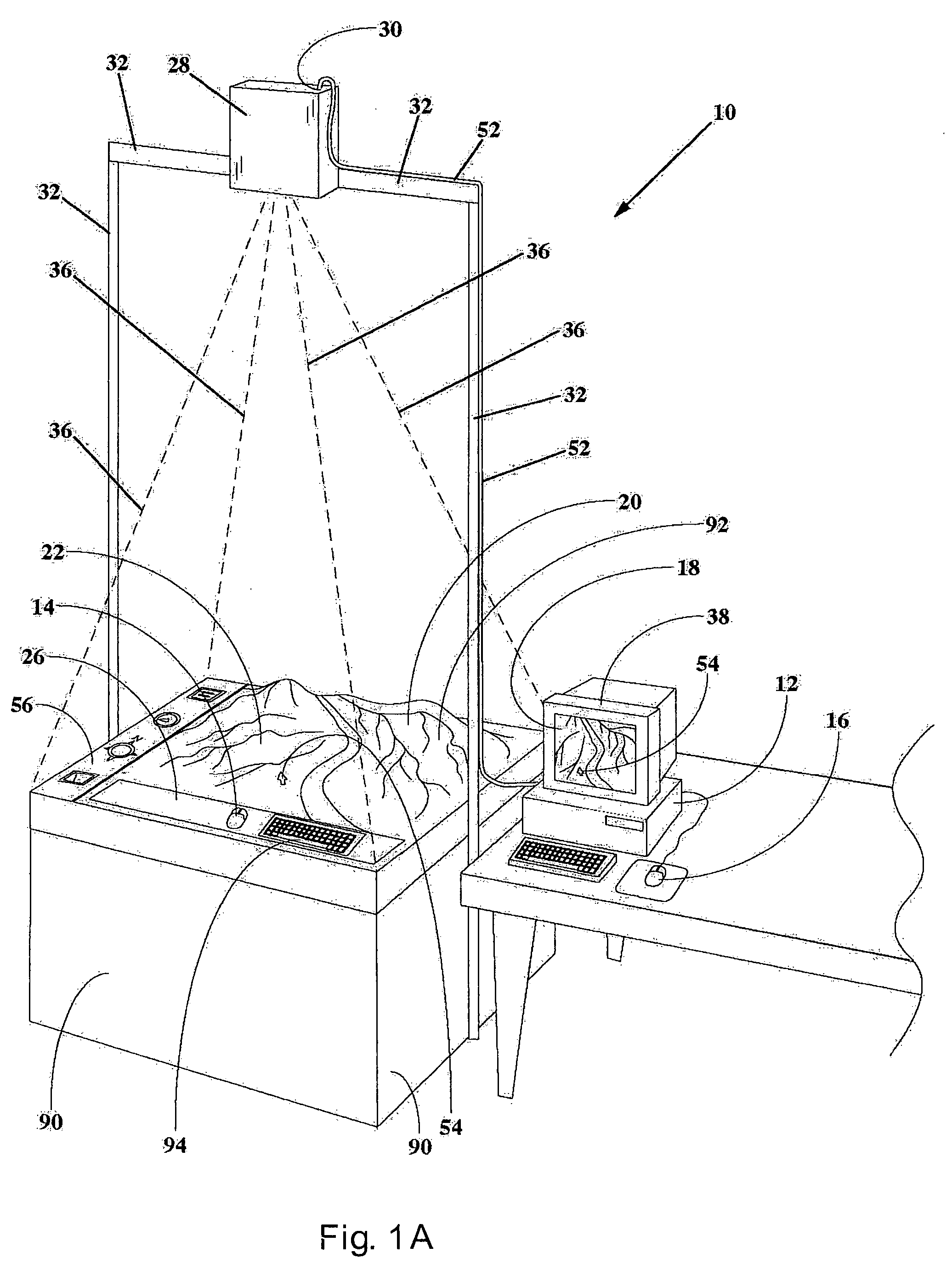
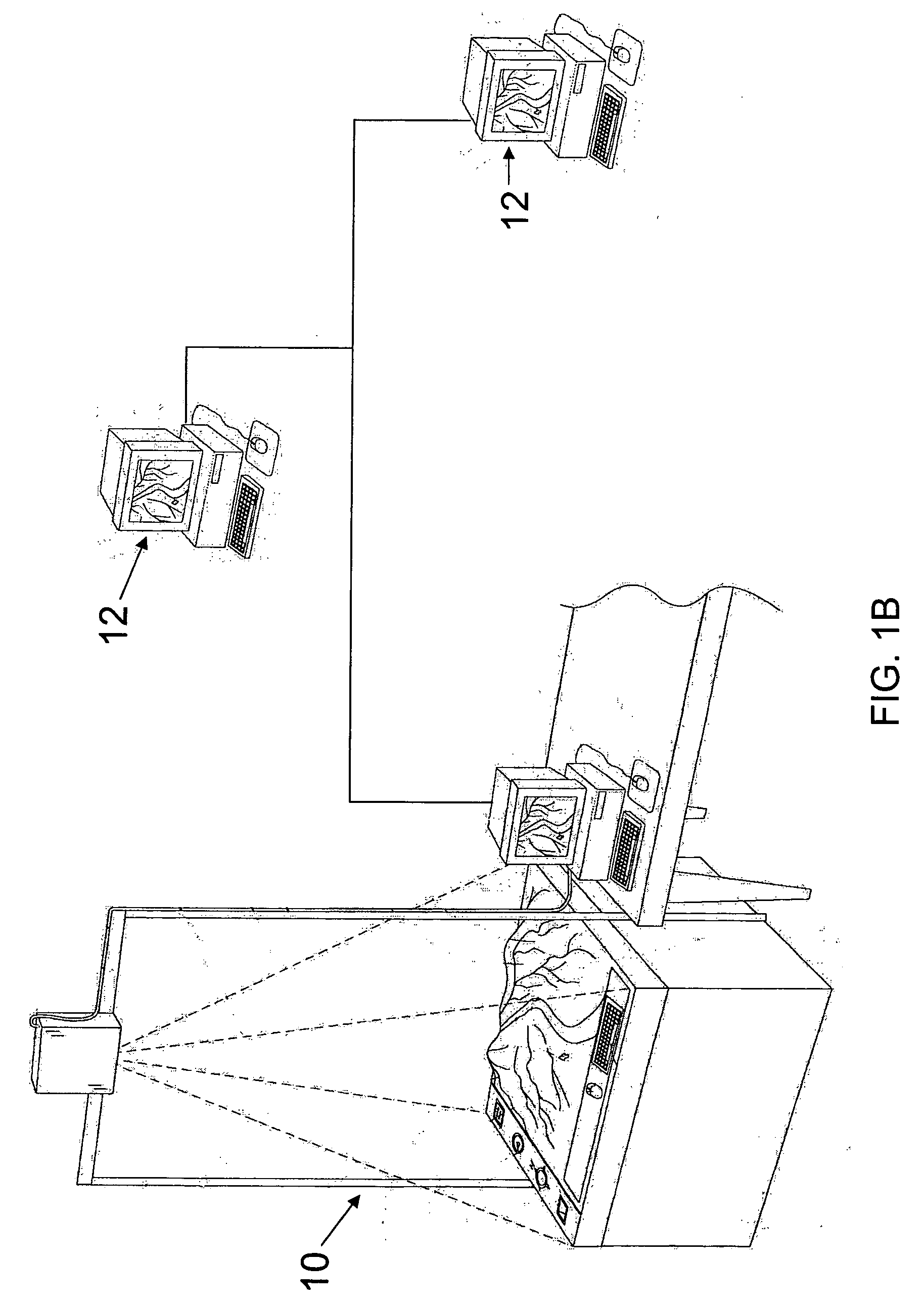
[0023] In FIG. 1A, a depiction of the three-dimensional cartographic user interface system 10 is depicted with a projected image 36 (shown in dashed-lines) being projected downward onto the upper surface 22 of three-dimensional topographical map 20 from a projector 28 mounted above the map. The projector has a video signal input 30 which receives video signal from computer 12 via video cable 52. Alternatively, the system can be equipped with one or more laser projection means which project discernible content comprised of one or more projected laser lights. One or more maps 20 can be mounted in a fixed, or exchangeable, manner on an upper surface of a map stand or map pedestal 90. Preferably, when more than one map 20 is mounted on pedestal 90, the maps are aligned adjacent to one another in a manner having a substantially seamless appearance and suitable for being viewed by and facilitating interactivity with at least one user.

[0024] While a single projector is shown in FIG. 1A, i...


PUM


Abstract

A three-dimensional cartographic computer user interface system for enhancing geo-spatial comprehension and geographic information system user interactivity is disclosed. The system has at least one computer and operating system, user input means, and at least one positionable projection display means, including storage, retrieval and playback control means for the projected content. The system has user input device software responsive to input from at least one user input device which is operable on a three-dimensional user interface surface of the system, and software for the display and control of cartographic-related projected imagery, and software for the display and control of three-dimensional user interface-related content superimposed within the cartographic-related projected imagery. The system includes at least one cartographic map having at least one surface portion which is three-dimensionally shaped to represent topographic terrain of at least one geographical location and optionally includes a substantially planar surface onto which cartographic-related content is projected.

Description

CROSS-REFERENCE TO CO-PENDING PATENT APPLICATIONS [0001] The present application is a non-provisional patent application which relies on provisional patent application 60 / 615,246 filed on Oct. 4, 2004, and is related to co-pending patent applications 60 / 195,129 and 60 / 195,130 both filed on Apr. 6, 2000, the complete disclosures of which are hereby incorporated by reference.FIELD OF THE INVENTION [0002] The present invention pertains to the field of cartography. It is generally directed to geographic information systems (‘GIS’) that are interactive with one or more users through computer user interfaces and input devices, computer software responsive to input from such devices, and computer display systems for displaying visual feedback in relation to user-input by one or more users. More particularly, the invention relates to a three-dimensional cartographic user interface system (hereinafter referred to as ‘3D-CUI’) having one or more input-device drivers and cartographic-related o...

Claims


Application Information

Patent Timeline
IPC IPC(8): G06F17/00
CPCG06T17/05G09B29/001G09B29/10G09B29/12G09B25/06
Inventor FAULKNER, LAWRENCE Q.FISHER, MARK E.LUTON, JUSTIN
Owner SOLID TERRAIN MODELING
Why Eureka
Try Eureka