GPS-based steering needle instrument

a technology of steering needle and GPS, applied in the field of navigation, can solve the problems of limited access, obstructed signals of mountains, and inaccessible routes,

Inactive Publication Date: 2006-07-20
EMBRY RIDDLE AERONAUTICAL UNIV
View PDF8 Cites 26 Cited by
  • Summary
  • Abstract
  • Description
  • Claims
  • Application Information

AI Technical Summary

Benefits of technology

[0019] The present invention comprises a flight instrument enabling a pilot to intercept and precisely follow a predefined GPS track. The instrument—known as a GPS steering indicator—provides a visual display which is similar in appearance to other aircraft instruments (and therefore instantly recognizable to nearly all pilots). However, the instrument is preferably differentiated somewhat in its visual appearance to convey to the pilot the fact that it displays steering commands rather than cross track error. An indicator needle deflects to instruct the pilot which way to turn and how much to turn in order to intercept and fly along a predefined GPS track. By centering the indicator needle, the pilot maintains the desired instantaneous track.
[0020] The invention can be enhanced by providing additional features to the instrument, such as a non-linear scale with heightened sensitivity near the center. Other additional features may include turn cues and a countdown to the next required maneuver. The instrument can also be programmed to provide cues by moving the indicator needle itself, such as gradually deflecting the indicator needle in the direction of an upcoming turn several seconds prior to actually reaching the curve in the GPS track.
[0021] The invention can be further enhanced by “fusing” different information sources. For example, the steering needle concept can fuse localizer (the lateral deviation portion of an Instrument Landing System) and GPS data, such that the GPS data provides the ground track data ordinarily estimated by a Flight Director, and the localizer provides the guidance required for the approach. This data fusion provides localizer accuracy with the ease of use of the GPS steering needle concept.

Problems solved by technology

Such a route is not available, however, since VOR2 is not within range of the origin airport.
Their signals can be obstructed by mountains.
Their accessibility is also limited by the altitude of the aircraft, with the range being reduced when an aircraft is at low altitude.
By the same token, existing GPS navigation devices are known to have certain well-accepted limitations, including: (1) They require the pilot to estimate headings in order to intercept a course line and to then track the course line, increasing the pilot's work load; and (2) They require the pilot to use a generally separate heading device, such as a directional gyroscope (introducing traditional problems such as gyroscopic precession, inaccurate initialization of the gyro compass, etc.).
The increased work load results from the system's reliance on the pilot's mental calculations.
Performing such a maneuver consumes a substantial portion of the pilot's available working capacity.
Flight Directors have disadvantages, however, including: (1) They are far too expensive for implementation in most small aircraft; (2) They require a modified attitude indicator in order to display the pitch and roll commands; (3) They require an accurate and integrated heading source; and (4) They depend upon the integration of several previously separate systems (attitude indicator, gyro compass etc.).
If one of the primary instruments fails, the Flight Director is unlikely to provide meaningful assistance.

Method used


Image

  • GPS-based steering needle instrument
  • GPS-based steering needle instrument
  • GPS-based steering needle instrument

Examples


Embodiment Construction

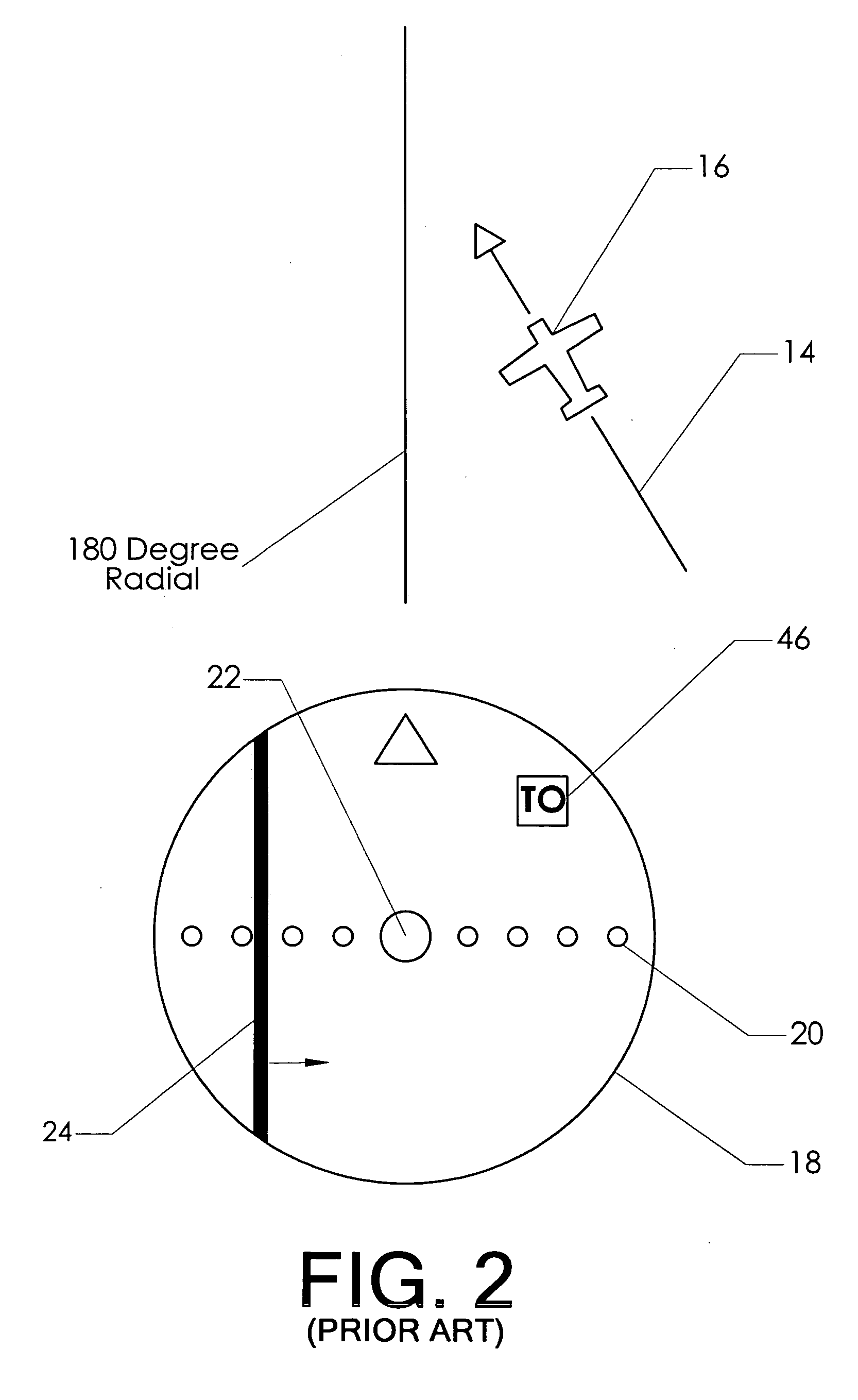
[0040]FIG. 4 is a schematic plan view graphically displaying some common navigation terms which are useful to the reader's understanding. Aircraft 16 is attempting to fly along desired course 32, which lies between two waypoints (WPT1 and WPT2). The aircraft is oriented along a heading 28. The cross wind causes the aircraft to move along ground track 14, meaning that it is slipping laterally as it flies instead of moving purely along its heading. Target bearing 30 is a vector drawn from the aircraft to the destination (WPT2).

[0041] The reader will observe that the aircraft is located some distance away from the desired course. This distance is commonly known as cross track error 34, which represents the perpendicular distance between the aircraft and the desired course.

[0042] Significantly, GPS navigation units have the ability to accurately measure two of the most important values shown in FIG. 4 (The term “GPS navigation unit” will be understood to include the actual receiving u...


PUM


Abstract

A a flight instrument enabling a pilot to intercept and precisely follow a predefined GPS track. The instrument—known as a GPS steering indicator—provides a visual display which is similar in appearance to other aircraft instruments (and therefore instantly recognizable to nearly all pilots). However, the instrument is preferably differentiated somewhat in its visual appearance to convey to the pilot the fact that it displays steering commands rather than cross track error. An indicator needle deflects to instruct the pilot which way to turn and how much to turn in order to intercept and fly along a predefined GPS track. By centering the indicator needle, the pilot maintains the desired instantaneous track.

Description

BACKGROUND OF THE INVENTION [0001] 1. Field of the Invention [0002] This invention relates to the field of navigation. More specifically, the invention comprises a needle indicator which provides a simple visual reference allowing a user to guide a moving vehicle along a defined course. The invention can use a course defined by waypoints or just a constant track made good (angle over the ground). [0003] 2. Description of the Related Art [0004] Aircraft navigation has been focused for the past several decades on radio frequency instruments. One common instrument is a VHF Omni Range station (“VOR”). Those skilled in the art will know that VOR's transmit a signal with two modulations, and that the phase difference between these two modulations is read by airborne instruments to display the radial “from” or bearing “to” the VOR station. [0005] In use, a VOR receiver is typically set to “look” for a specific radial (such as the 180 degree radial, or the 255 degree radial). A visual indic...

Claims


Application Information

Patent Timeline
Patent Type & Authority Applications(United States)
IPC IPC(8): G06F19/00G01C21/36G01S19/48
CPCG01C23/00
Inventor WISCHMEYER, CARL EDWARD
Owner EMBRY RIDDLE AERONAUTICAL UNIV
Why Eureka
Try Eureka