System and method for geo-registration with global positioning and inertial navigation

Active Publication Date: 2006-12-28
RAYTHEON CO
View PDF10 Cites 29 Cited by
  • Summary
  • Abstract
  • Description
  • Claims
  • Application Information

AI Technical Summary

Benefits of technology

[0009] In the illustrative application, geo-registered SAR/FLIR imagery is used to track targets and to determine a target location error (TLE). This TLE information is a set of error equations that describe the relationship between vehicle navigation information and target data. In acc

Problems solved by technology

Unfortunately, inertial navigation accuracy degrades because of instrument calibration errors and other errors.
These navigation errors typically grow as a function of time.
However, th

Method used


Image

  • System and method for geo-registration with global positioning and inertial navigation
  • System and method for geo-registration with global positioning and inertial navigation
  • System and method for geo-registration with global positioning and inertial navigation

Examples


Embodiment Construction

[0013] Illustrative embodiments and exemplary applications will now be described with reference to the accompanying drawings to disclose the advantageous teachings of the present invention.

[0014] While the present invention is described herein with reference to illustrative embodiments for particular applications, it should be understood that the invention is not limited thereto. Those having ordinary skill in the art and access to the teachings provided herein will recognize additional modifications, applications, and embodiments within the scope thereof and additional fields in which the present invention would be of significant utility.

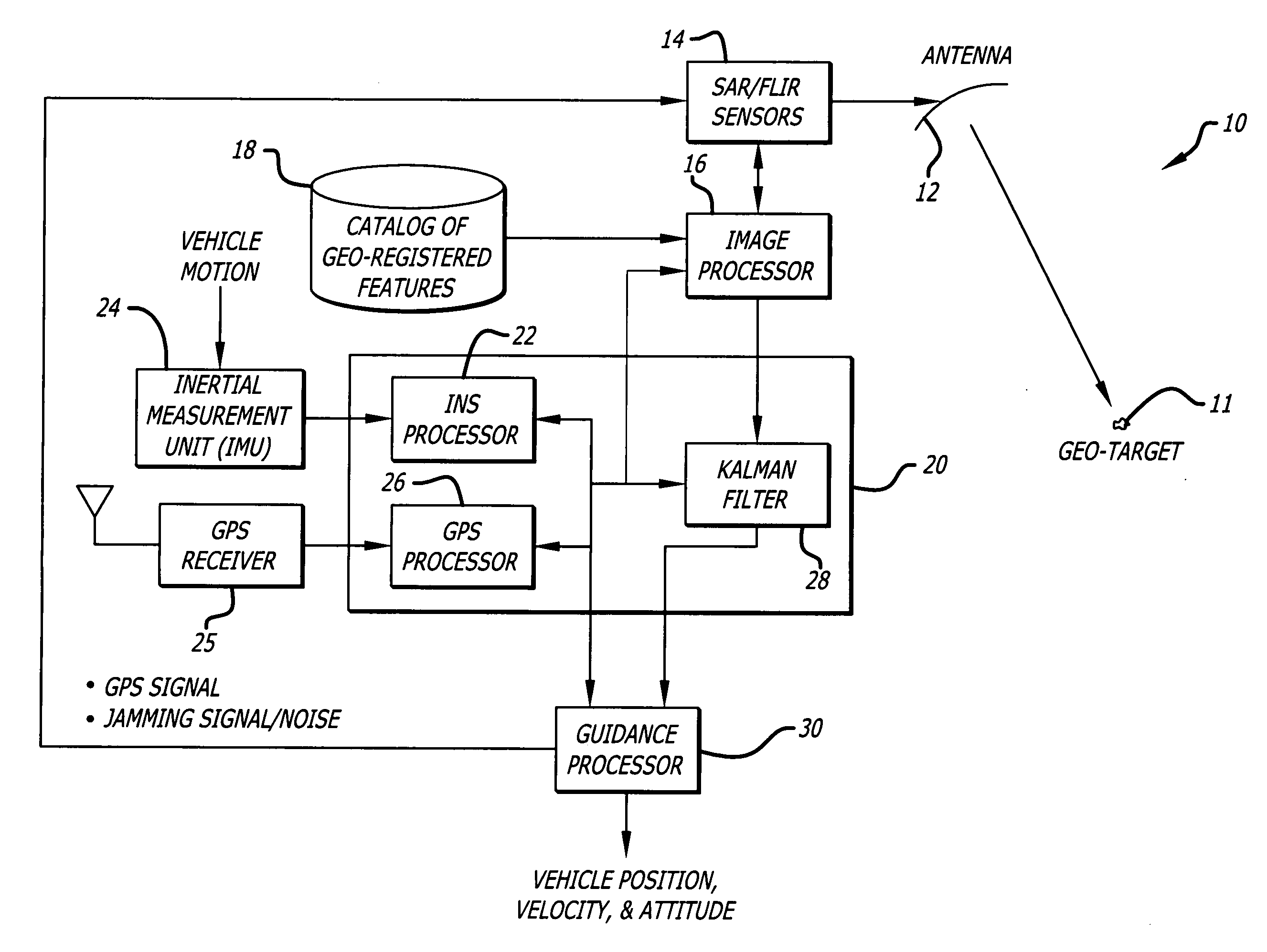
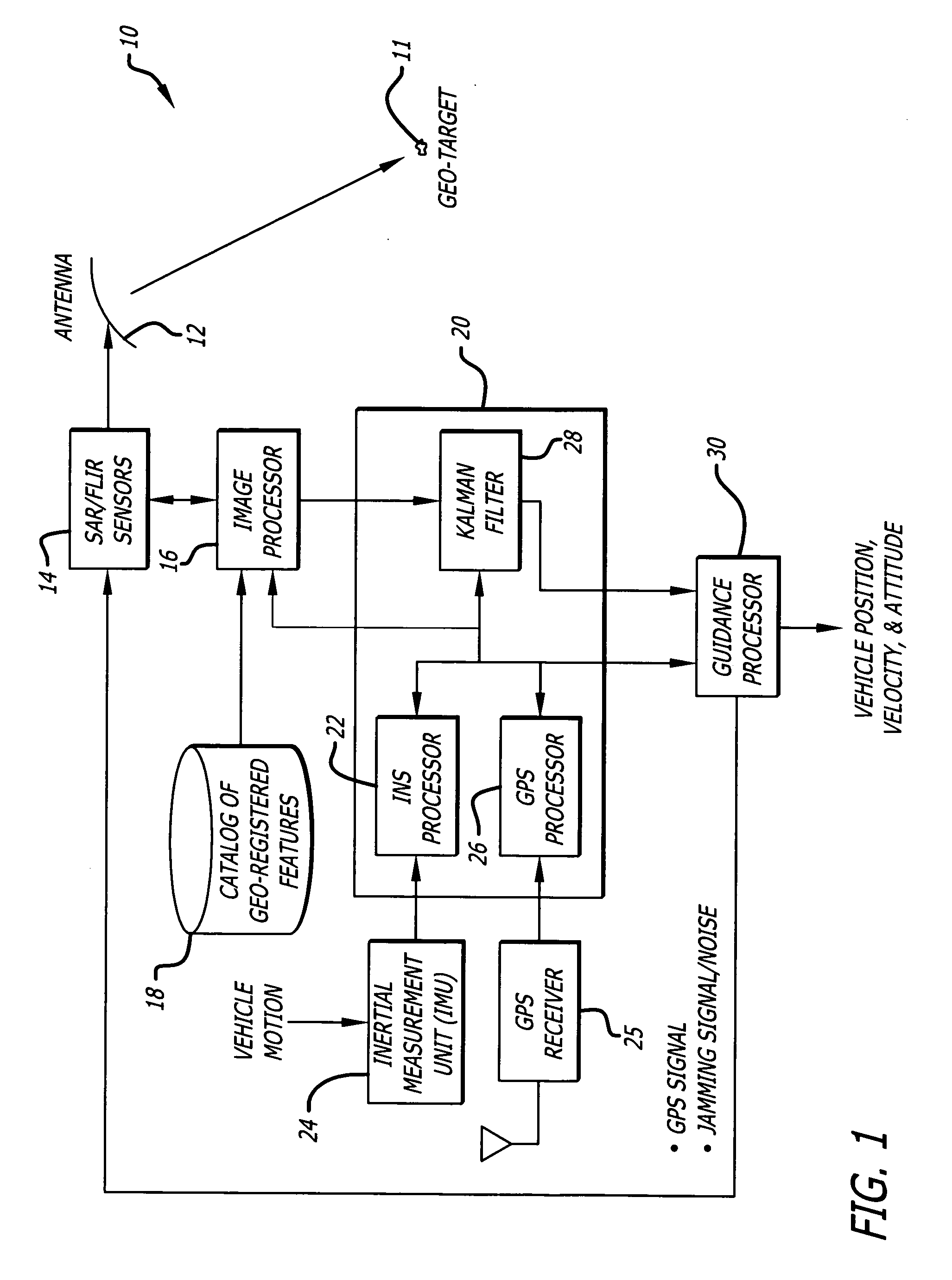
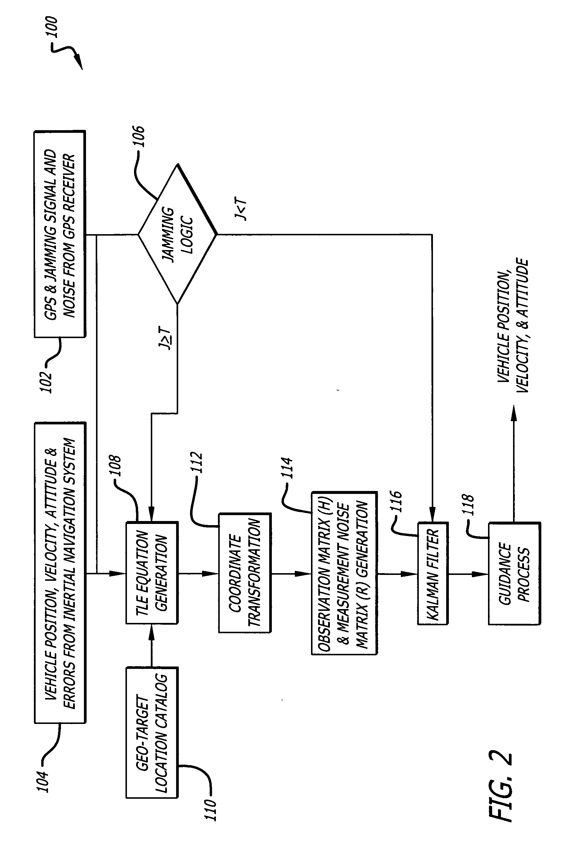
[0015] In general, in accordance with the present teachings, geo-registered SAR / FLIR imagery is used to track targets and to determine a target location error (TLE). The TLE is generated by a set of error equations that describe the relationship between the vehicle (sensor) navigation information and the target location. The geo-registered images...


PUM


Abstract

A position estimation system including a first arrangement for providing an image with a known target in a known reference frame. A second arrangement correlates the image with a stored image. The correlation is used to compute an error with respect to a position estimate. In a specific embodiment, the error is referenced with respect to first (x), second (y) and third (z) directions. A target location error is computed with respect to a stored image provided by a target image catalog. The target image catalog includes target geo-locations and digital terrain elevation data. In an illustrative application, the image data is provided by synthetic aperture radar and forward-looking infrared systems. An observation model and a measure noise matrix are Kalman filtered to ascertain a position error in navigation data generated by an integrated inertial navigation and Global Positioning system. In the illustrative application, geo-registered SAR/FLIR imagery is used to track targets and to determine a target location error (TLE). This TLE information is a set of error equations that describe the relationship between vehicle navigation information and target data. In accordance with the invention, this relationship is used to form an observation model for vehicle navigation with respect to target locations. Using Kalman filtering and the observation model, vehicle navigation errors can be bound and the navigation accuracy of the vehicle can be improved.

Description

BACKGROUND OF THE INVENTION [0001] 1. Field of the Invention [0002] The present invention relates to inertial navigation and global position. More specifically, the present invention relates to systems and methods for improving the GPS counter-jamming performance of inertial navigation systems. [0003] 2. Description of the Related Art [0004] Inertial navigation systems typically use gyroscopes and accelerometers to provide precision vehicular navigation. Unfortunately, inertial navigation accuracy degrades because of instrument calibration errors and other errors. These navigation errors typically grow as a function of time. Independent observations of the vehicle navigation information are needed to bind these navigation errors. Therefore, sensors, other than INS, are needed in order to obtain independent navigation information. Hence, a conventional approach for correcting these errors involves the integration of a Global Position System (GPS) receiver with the inertial navigation...

Claims


Application Information

Patent Timeline
IPC IPC(8): G01C21/00G01S19/09G01S5/14G01S19/46
CPCG01S7/40G01S13/9035G01S13/867G01S19/47G01S19/21G01S13/90
Inventor CHIOU, KUO-LIANGRUDOLPH, KEVIN E.CHIOU, CARROLL C.
Owner RAYTHEON CO
Why Eureka
Try Eureka