Unassisted indoor GPS receiver

Active Publication Date: 2007-07-05
SAMSUNG ELECTRONICS CO LTD
View PDF24 Cites 54 Cited by
  • Summary
  • Abstract
  • Description
  • Claims
  • Application Information

AI Technical Summary

Benefits of technology

[0018] In yet another embodiment, a Fast Fourier Transfer (FFT) technique is used to determine the carrier frequency when there are wide frequency swings due to high dynamics. This allows

Problems solved by technology

But providing this type of assistance requires additional infrastructure and may not be available in all places.
Most of the standalone high sensitivity GPS receivers are based on a long non-coherent integration involving squaring loss and thus reducing the possible gain while taking a long time to acquire the satellite signal under weak signal conditions.
However, these parameters help only in reducing the search frequency band.
But there are no poly

Method used


Image

  • Unassisted indoor GPS receiver
  • Unassisted indoor GPS receiver
  • Unassisted indoor GPS receiver

Examples


Embodiment Construction

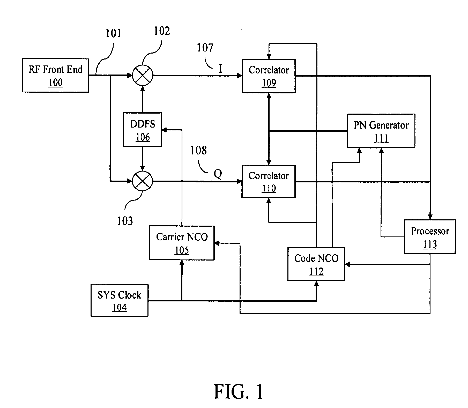
[0024]FIG. 1 is a functional block diagram of a GPS receiver according to an embodiment of the present invention. An RF front-end 100 processes the RF signal received at the antenna (not shown). Operations of a conversional RF front-end 100 include amplification, down-conversion, and analog-to digital conversion. The RF front end 100 outputs an intermediate frequency (IF) signal 101 to a baseband section of the receiver from its analog-to-digital converter (ADC) output (not shown). The RF front-end 100 down converts the received RF into the intermediate frequency (IF) for baseband processing. The IF signal 101 is made available to two paths, one in-phase (I) and the other in-quadrature (Q). In the I path, the IF signal 101 is multiplied in IF mixer 102 in-phase with a local frequency signal generated by a direct digital frequency synthesizer (DDFS) 106 to produce the in-phase (I) component 107. In the Q path, the same signal 101 is multiplied by the DDFS frequency in-quadrature (i.e...


PUM


Abstract

The present invention provides GPS receivers capable of tracking very weak GPS signals particularly in an indoor environment without assistance from an external server or a network. In a preferred embodiment, a GPS receiver initially acquires and locks onto GPS satellite signals to compute receiver position outdoors. The GPS receiver then tracks at least one satellite signal indoors to maintain acquisition parameters for quick acquisition of GPS signals. To save power, the receiver automatically goes to the sleep state and periodically wakes up, i.e., powers up, to maintain the at least one satellite signal tracking. During the wakeup state, the receiver collects ephemeris data from the at least one satellite signal when the ephemeris data needs to be updated for quick acquisition of GPS signals.

Description

FIELD OF THE INVENTION [0001] The present invention relates to satellite based navigational receivers, and more particularly to efficient tracking and reacquisition of navigational signals under weak signal conditions and / or indoor operations. BACKGROUND [0002] The global positioning system (GPS) is a satellite based radio-navigation system built and operated by the United States Department of Defense. The Russian government operated ‘GLONASS’ and European Union proposed ‘Galileo’ are two other important satellite based navigational systems. [0003] GPS permits a user of the system to determine his or her position on the surface of the earth. The system consists of twenty-four satellites circling the earth at an altitude of about 11,000 miles with a period of about 12 hours. It is possible to have more than twenty-four satellites due to the presence of some spare satellites in the GPS constellation. These satellites are placed in six different orbits such that at any time a minimum o...

Claims


Application Information

Patent Timeline
IPC IPC(8): G01S5/14G01S19/23G01S19/24G01S19/27G01S19/29G01S19/34
CPCG01S19/24G01S19/27G01S19/246G01S19/34G01S19/29
Inventor WANG, CHI-SHINQIU, ZONGDEKUDRETHAYA, SHRIDHARA A.MO, JUN
Owner SAMSUNG ELECTRONICS CO LTD
Why Eureka
Try Eureka