Method and system for selecting and providing a relevant subset of wi-fi location information to a mobile client device so the client device may estimate its position with efficient utilization of resources

a technology of wi-fi location and mobile client device, applied in the direction of wireless communication, instruments, assessment restrictions, etc., can solve the problems of substantial errors, interference with the process, and confusion of the receiver

Active Publication Date: 2008-07-24
SKYHOOK WIRELESS
View PDF70 Cites 510 Cited by
  • Summary
  • Abstract
  • Description
  • Claims
  • Application Information

AI Technical Summary

Problems solved by technology

Weather, buildings or structures, and foliage can interfere with this process because the receivers require a clear line-of-sight to three or more satellites.
The radio signals from the satellites bounce off physical structures causing multiple signals from the same satellite to reach a receiver at different times. Since the receiver's calculation is based on the time the signal took to reach the receiver, multi-path signals confuse the receiver and cause substantial errors.
Unfortunately these approaches have proven to be suboptimal due to the heterogeneous nature of the cellular tower hardware along with the issues of multi-path signals and the lack of uniformity in the positioning of cellular towers.
These systems have been plagued by slow response times and poor accuracy—greater than 100 meters in downtown areas.
The challenges facing this model are the cost of the new hardware receiver and the limitations of using such a small set of reference points.
For example, if a user is outside the perimeter of towers, the system has a difficult time providing reasonable accuracy.
Since there are no TV towers out in the ocean, there is no way to provide reference symmetry among the reference points resulting in a calculated positioning well inland of the user.
Because individuals voluntarily supply the data, these systems suffer from a number of performance and reliability problems.
As a result, the access point information in the database lacks a common standard of reference.
Third, the user-supplied data suffer from arterial bias.
Because the data is self-reported by individuals who are not following designed scanning routes, the data tends to aggregate around heavily trafficked areas.
Arterial bias causes location estimates to be “pulled” towards main arteries, resulting in substantial accuracy errors.
Fourth, these databases include the calculated position of scanned access points rather than the raw scanning data obtained by the 802.11 hardware.
The result is that the location estimates for some access points in the database are highly inaccurate.
The accuracy requirements for these use cases are very demanding typically calling for 1-3 meter accuracy.
While these systems are becoming more reliable for these indoor use cases, they are ineffective in any wide-area deployment.
It is impossible to conduct the kind of detailed site survey required across an entire city and there is no way to rely on a constant communication channel with 802.11 access points across an entire metropolitan area to the extent required by these systems.
Most importantly outdoor radio propagation is fundamentally different than indoor radio propagation rendering these indoor positioning algorithms almost useless in a wide-area scenario.
Software that operates on mobile devices is often constrained by the limited physical capabilities of such devices and the cost of mobile resources and services.
These constraints include both hardware (memory capacity, power storage and consumption, CPU speed, network capacity and availability) as well as cost constraints for network access and bandwidth consumption.
These limitations place a burden on any solution that intends to make use of the available resources, and in particular, create an optimization problem for efficiently managing and distributing Wi-Fi location data.
This optimization problem is compounded by the fact that the Wi-Fi location database itself requires frequent updates.

Method used


Image

  • Method and system for selecting and providing a relevant subset of wi-fi location information to a mobile client device so the client device may estimate its position with efficient utilization of resources
  • Method and system for selecting and providing a relevant subset of wi-fi location information to a mobile client device so the client device may estimate its position with efficient utilization of resources
  • Method and system for selecting and providing a relevant subset of wi-fi location information to a mobile client device so the client device may estimate its position with efficient utilization of resources

Examples


example intended use

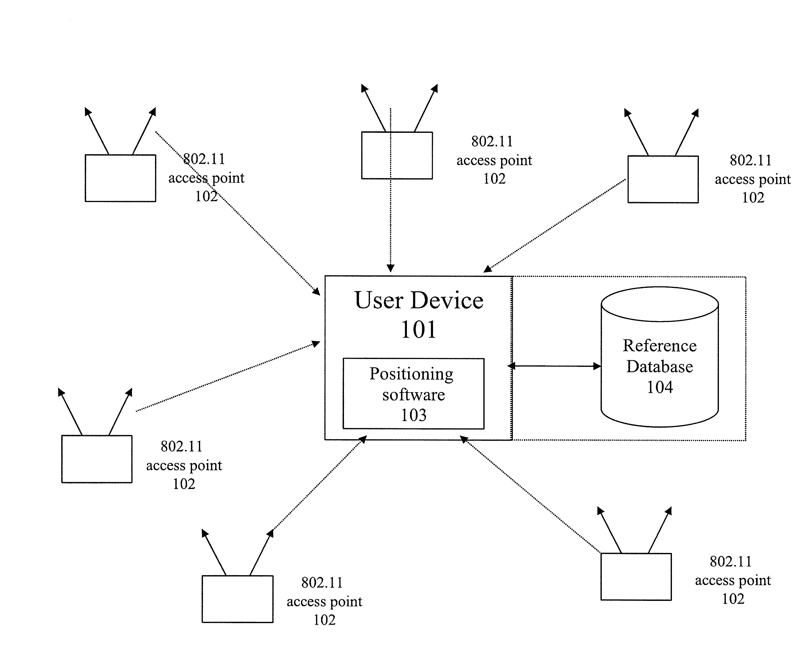
[0135]The following illustrates an example projected use of certain embodiments of the invention. In this example scenario, the user of a mobile device equipped with WPS software lives in a suburb of a city but works downtown. In the morning, the user asks the device (via a User Application such as navigation software) to determine the current location. This action triggers the WPS software to activate.

[0136]In this scenario, the User Application requests the location from the WPS Location Provider. The WPS Location Request Manager makes a request to the Client Device Location Estimation Module. If the LEM is unable to provide a location autonomously, the Location Request Manager passes control to the Data Communication Manager to request and retrieve location and WPS Tiles as necessary from the Central Server. The results of a Wi-Fi scan are passed to the server and the server responds with a list of recommended TileIDs that are prioritized according to the factors listed above. Th...


PUM


Abstract

Methods and systems for selecting and providing a relevant subset of Wi-Fi location information to a mobile client device so the client device may estimate its position with efficient utilization of resources.A method of providing a relevant subset of information to a client device is based in part on scanning for Wi-Fi access points within range of the client device, using a Wi-Fi database that covers a large target region to retrieve information about these access points, using this information to estimate the position of the mobile client device, selecting a limited region in the vicinity of the estimated location of the client device, and providing information about Wi-Fi access points within this limited region to the client. For efficient transfer and maintenance of data, the target region may be divided into a hierarchy of fixed geographical tiles.

Description

CROSS-REFERENCE TO RELATED APPLICATIONS[0001]This application is a continuation-in-part of and claims priority under 35 U.S.C. §120 to U.S. patent application Ser. No. 11 / 261,898 filed on Oct. 28, 2005, entitled Server for Updating Location Beacon Database, which is incorporated herein by reference in its entirety.BACKGROUND[0002]1. Field of the Invention[0003]The invention generally relates to methods and systems for determining the location of a Wi-Fi-enabled device, and, more specifically, to methods and systems for efficiently managing and distributing Wi-Fi location data to a mobile client device so the client can use such information to estimate its position.[0004]2. Discussion of Related Art[0005]In recent years the number of mobile computing devices has increased dramatically, creating the need for more advanced mobile and wireless services. Mobile email, walkie-talkie services, multi-player gaming and call-following are examples of how new applications are emerging on mobil...

Claims


Application Information

Patent Timeline
Patent Type & Authority Applications(United States)
IPC IPC(8): H04Q7/20H04W4/021H04W4/02H04W4/024H04W4/029H04W16/18H04W48/14H04W64/00H04W84/12
CPCG01S5/0236G01S5/0242H04W16/18H04W48/08H04W48/20H04W64/00H04W84/12H04W4/028H04W4/02H04W48/14H04W4/029H04W4/021H04W4/027G01S5/0295H04W4/024H04L67/5683H04W8/005
Inventor BRACHET, NICOLASALIZADEH-SHABDIZ, FARSHIDNELSON, JOEL N.JONES, RUSSEL K.
Owner SKYHOOK WIRELESS
Why Eureka
Try Eureka