Method and system for navigation using GPS velocity vector

a technology of gps and velocity vector, applied in the field of navigation services for computing devices, can solve the problems of user waiting at least, wasting time, and wasting time, and achieve the effect of accurate calculation

Active Publication Date: 2008-10-23
MITAC INT CORP
View PDF50 Cites 94 Cited by
  • Summary
  • Abstract
  • Description
  • Claims
  • Application Information

AI Technical Summary

Benefits of technology

[0016]Another aspect of the disclosed navigation device is operable to switch from a current Ephemeris based GPS solution for velocity and location to a DR solution when the last recorded Ephemeris is considered too old to allow accurate calculation of the velocity vector. Such a scenario may occur when a continuously powered navigation device is parked overnight in a parking structure, wherein the GPS receiver is unable to receive current Ephemeris, but is still able to acquire and track GPS signals. The method comprises continuo...

Problems solved by technology

However, the second part, collecting the GPS Ephemeris data, still takes about 30 seconds with a high signal-to-noise ratio (SNR), or an even longer period of time in the case of low SNR.
This long processing time results in a user having to wait at least an extra 30 seconds before getting guidance instruct...

Method used


Image

  • Method and system for navigation using GPS velocity vector
  • Method and system for navigation using GPS velocity vector
  • Method and system for navigation using GPS velocity vector

Examples


Embodiment Construction

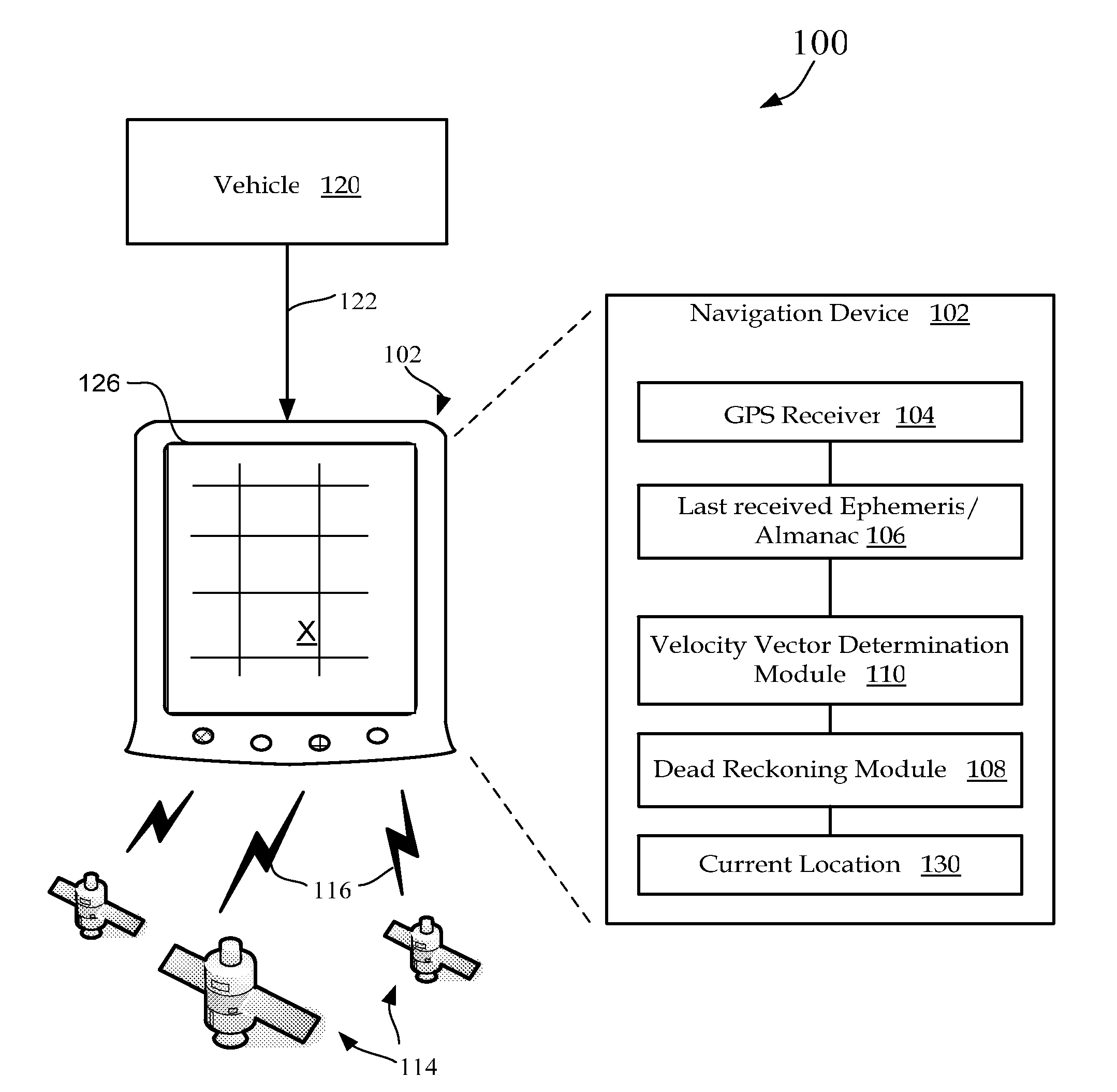
[0024]FIG. 1 illustrates one embodiment of a GPS navigation system 100 that includes a vehicle mounted navigation device 102 that receives a GPS signal 116 containing GPS position location parameters from several satellites 114 orbiting the earth at a distance of approximately 20,000 kilometers. In some embodiments, the navigation device 102 derives continuous power from a vehicle connected cable 122. In other embodiments navigation device 102 is powered only when the vehicle's ignition is on.

[0025]Based upon the received parameters, navigation device 102 determines its respective three dimensional position and velocity using very precise location parameters and timing signals received from the satellites 114. upon determining a current location 130, navigation device 102 is operable to display a position of the vehicle 120 on a display device 126.

[0026]GPS vehicle position is normally derived from the pseudo-range measurements from three or more satellites, the pseudo-range measure...


PUM


Abstract

A navigation device includes a computer platform that includes a global positioning system (GPS) receiver operable to acquire and track a GPS signal, a processor assembly, and a memory. The memory includes at least one of last recorded Ephemeris and Almanac information, and a GPS velocity vector determination module operable to generate a velocity vector output in the absence of current Ephemeris based upon the tracked GPS signal and the last recorded GPS information. A method of vehicle navigation in the absence of current Ephemeris includes acquiring and tracking a GPS signal, retrieving from a memory a last recorded location of a vehicle, setting a dead reckoning startup location equal to the last recorded location, retrieving from a memory at least one of a last recorded Ephemeris and Almanac, determining a current velocity vector and determining a current location based upon the velocity vector and the dead reckoning startup location.

Description

FIELD OF THE INVENTION[0001]The present invention relates generally to navigation services for a computing device, and more specifically to a method and apparatus for using a velocity vector derived from a GPS (Global Positioning System) signal and non-current Ephemeris or Almanac to perform navigation services.BACKGROUND OF THE INVENTION[0002]Global Navigation Satellite Systems (GNSS) allow navigation services including automatic route calculation from a current location to a destination location and guiding a driver of a vehicle to that destination with real time instructions in conjunction with a visual display of route segments as the vehicle progresses along the route.[0003]Several different approaches for position location are known, including for example, terrestrial methods, GNSS methods, and hybrids of terrestrial and satellite-based methods. One such GNSS is the Global Positioning System (GPS), developed and operated by the U.S. Defense Department, which includes a constel...

Claims


Application Information

Patent Timeline
IPC IPC(8): G01C21/00G01S19/48
CPCG01C21/165G01S19/48G01S19/52
Inventor LOKSHIN, ANATOLEKULIK, VICTOR
Owner MITAC INT CORP
Why Eureka
Try Eureka