
4D GIS based virtual reality for moving target prediction

a virtual reality and target technology, applied in the field of computer vision systems, can solve the problems of not being able to predict future locations, not addressing the key issue of how to apply terrain and mobility factors, and current targeting systems such as advanced field artillery tactical data systems (afatds) cannot predict future locations, so as to increase the degree of confidence of target motion prediction processes

Active Publication Date: 2009-04-02
AMERICAN GNC
View PDF10 Cites 334 Cited by
  • Summary
  • Abstract
  • Description
  • Claims
  • Application Information

AI Technical Summary

Benefits of technology

[0009]Another object of the present invention is to develop a method and a system of 4D GIS based reality for moving target prediction with visualization and 4D simulation, wherein new methodology and advanced algorithms are developed and established for 3D virtual terrain generation and predicted motion simulation. The main advanced component algorithms include 3D terrain generation and 3D animation synthesis to generate virtual reality of target moving simulation. The 3D virtual terrain is generated from the elevation data of GIS using the ESRI software product ArcView and 3D Analyst. Elevation data, also called the “terrain skin”, is a numeric representation that accurately portrays the character of the landscape. This data is an essential element of any database used to develop an accurate virtual environment. ESRI ArcView 3D Analyst supports Triangulated Irregular Networks (TINs). TINs are vector based topologically structured models that have desirable characteristics for representing terrain and other surfaces.
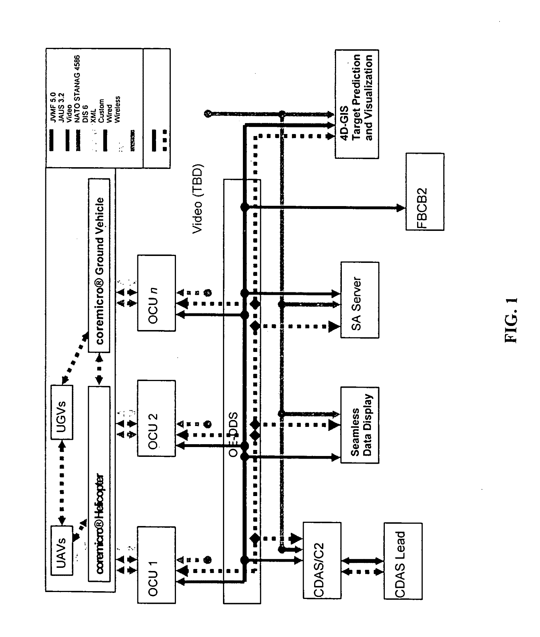
[0012]Another object of the present invention is to develop a system which is able to operate autonomously for extended periods, and is able to collaboratively engage hostile targets within specified rules of engagement, wherein all assets are able to share a COP (common operating picture) of the battle space and communicate sensor and target data in real time thus allowing for human or UMS target acquisition and location, transmission of the target to a weapon-target pairing system, and automated assignment of the target to a human or UMS asset as best suited.
[0025]Geospatial reasoning based on spatiotemporal data mining, which will increase the degree of confidence of the target motion prediction processes.

Problems solved by technology

Current targeting systems such as Advanced Field Artillery Tactical Data System (AFATDS) do not have the ability to predict future locations of moving targets being tracked within the COP.
Although these systems can perform some limited terrain and mobility analysis calculations that are static in nature, they do not address the key issue of how to apply terrain and mobility factors to attack a moving target.

Method used


Image

  • 4D GIS based virtual reality for moving target prediction
  • 4D GIS based virtual reality for moving target prediction
  • 4D GIS based virtual reality for moving target prediction

Examples


Embodiment Construction

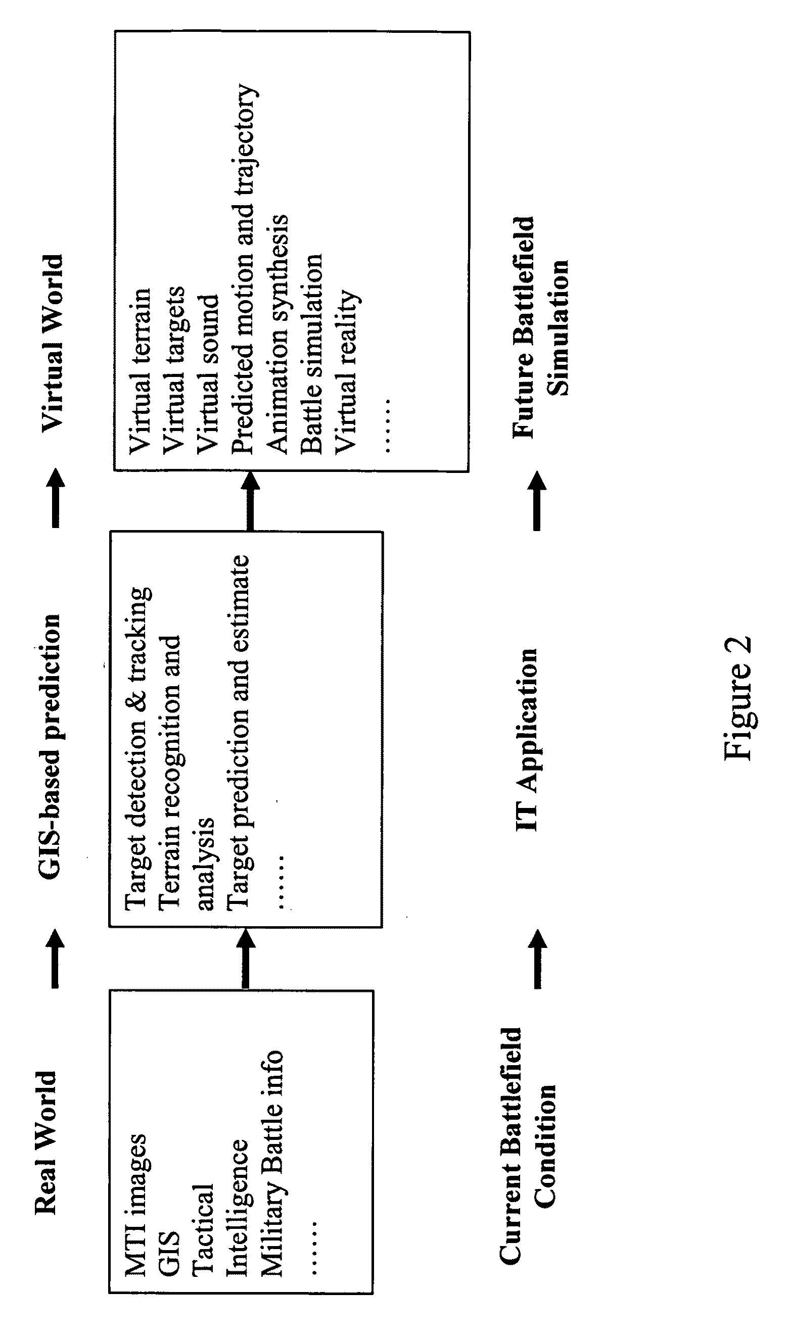
[0091]The present invention is outlined below:[0092]The created system concept of moving target prediction and simulation is to use information technology to analyze the current battlefield situation (real world), then predict and simulate the future battlefield possible condition (virtual world). The input to the system is the real world description of the current battlefield, and the output is the virtual world through the simulation of the future battlefield, as shown in FIG. 2.[0093]The developed method for the real world description of the current battlefield's status includes images from the moving target indication (MTI) sensors, geographic environment and condition of the battlefield from GIS, military intelligence, and related battlefield data from some military decision-making system, such as CDAS and AFATDS.[0094]The designed system architecture consisting of: (1) moving target tracking and prediction, and (2) target motion 4D simulation, as shown in FIG. 3. The tracking ...


PUM


Abstract

The technology of the 4D-GIS system deploys a GIS-based algorithm used to determine the location of a moving target through registering the terrain image obtained from a Moving Target Indication (MTI) sensor or small Unmanned Aerial Vehicle (UAV) camera with the digital map from GIS. For motion prediction the target state is estimated using an Extended Kalman Filter (EKF). In order to enhance the prediction of the moving target's trajectory a fuzzy logic reasoning algorithm is used to estimate the destination of a moving target through synthesizing data from GIS, target statistics, tactics and other past experience derived information, such as, likely moving direction of targets in correlation with the nature of the terrain and surmised mission.

Description

CROSS REFERENCE OF RELATED APPLICATION[0001]This is a regular application of a provisional application No. 60 / 965,855 filed on Aug. 22, 2007.GOVERNMENT INTERESTS[0002]This invention was made with Government support under contracts W115QKN-06-C-0014 and W15QKN-06-C-0202 awarded by the US ARMY. The Government has certain rights in the invention.BACKGROUND OF THE PRESENT INVENTION[0003]1. Field of Invention[0004]The present invention relates to developing computer vision systems that are installed on unmanned aerial vehicles (UAV) and unmanned ground vehicles (UGV) for autonomous flight, surveillance, object recognition, tracking, as well as other missions.[0005]2. Description of Related Arts[0006]Current targeting systems such as Advanced Field Artillery Tactical Data System (AFATDS) do not have the ability to predict future locations of moving targets being tracked within the COP. Although these systems can perform some limited terrain and mobility analysis calculations that are stat...

Claims


Application Information

Patent Timeline
Patent Type & Authority Applications(United States)
IPC IPC(8): G06K9/00G06V20/13
CPCG06K9/00208G06K9/0063G06K9/3241G06T2207/30241G06T2207/10016G06T2207/30212G06T7/208G06T7/277G06V20/647G06V20/13G06V10/255
Inventor COLEMAN, NORMAN P.LIN, CHING-FANG
Owner AMERICAN GNC
Learn More