Relative vehicular positioning using vehicular communications

a vehicular communication and relative technology, applied in the field of vehicular communication, can solve the problems of two gps receivers, the error of a typical gps receiver can be up to 10 meters, and the inherent inaccuracy of gps, so as to improve the relative positioning system, reduce traffic accidents and fatalities, and increase the relative position accuracy

Active Publication Date: 2011-05-12
AUTOTALKS
View PDF29 Cites 12 Cited by
  • Summary
  • Abstract
  • Description
  • Claims
  • Application Information

AI Technical Summary

Benefits of technology

Cooperative safety systems based on vehicle-to-vehicle communication show great promise to reduce the traffic accidents and fatalities. Therefore, there is a need for, and it would be advantageous to have, an improved relative positioning system and method to increase relative position accuracy and, consequently, vehicular safety.

Problems solved by technology

The GPS has inherent inaccuracy.
The error of a typical GPS receiver can be up to 10 meters.
In addition, two GPS receivers, located in proximity, may have different errors resulting from different selection of satellites or different processing orders of satellite signals.
The GPS performance degrades when line-of-sight (LOS) is unavailable.
No GPS signal is available inside buildings (such as indoor parking lots) and in tunnels.
The dead-reckoning error increases with usage time.
Dead-reckoning can provide approximate positioning for a short period of time, but is ineffective after long usage.
However, the problems of blocked GPS signals are not solved by this solution.
While GPS provides a sufficient level of accuracy for navigation purposes, this level of accuracy is not acceptable for supporting safety applications.

Method used


Image

  • Relative vehicular positioning using vehicular communications
  • Relative vehicular positioning using vehicular communications
  • Relative vehicular positioning using vehicular communications

Examples


Embodiment Construction

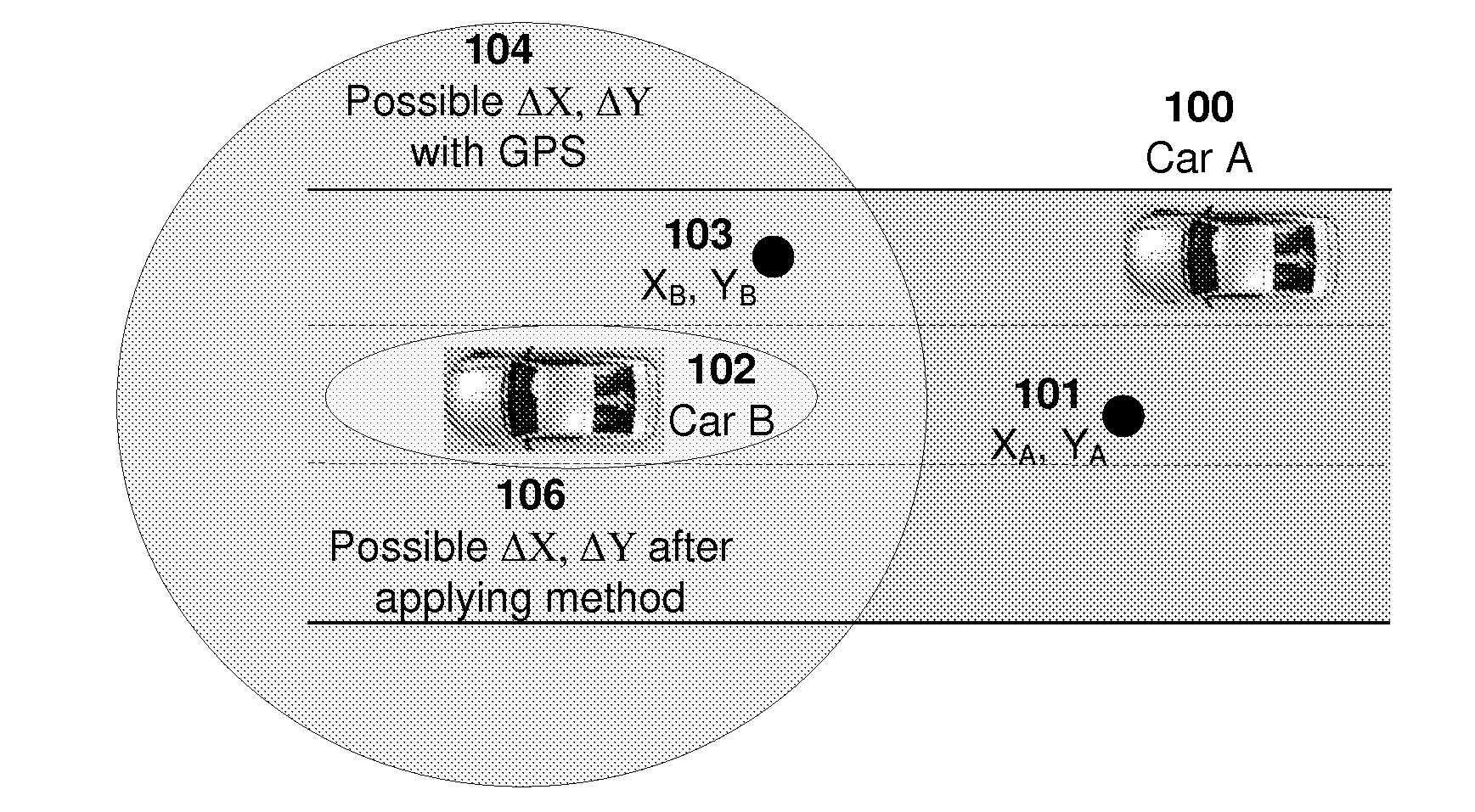
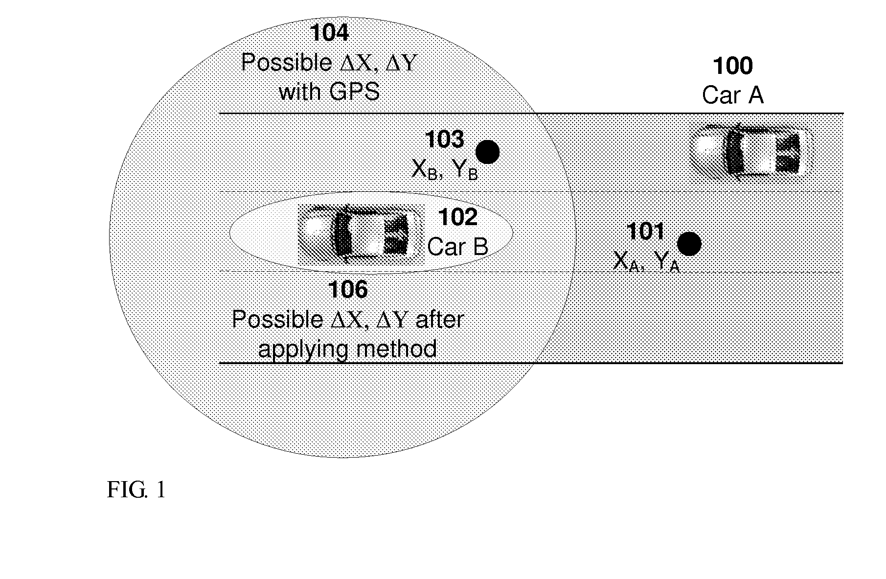
The invention provides methods and systems through which a first “measuring” vehicle (also referred to herein as “car”), exemplified in FIG. 1 by a car A, determines a position of a second “measured” vehicle, exemplified in FIG. 1 by a car B, relative to its own position. Cars A and B are shown driving to the left on a three-lane highway. Instant positions of car A, indicated by (XA, YA) point 102, and car B, indicated by (XB, YB) point 104 are provided for example by a GPS measurement. This measurement contains error, and with the additional error of the map database, it may provide an inaccurate lane position for both cars. The accumulated error for cars A and B is illustrated graphically by a circle 106. In FIG. 1, the (erroneous) instant X,Y values indicate that car B drives on a lane right of car A, which is of course wrong and opposite to the real situation.

A method of the invention corrects the wrong conclusion drawn from the instant position data, and identifies correctly th...


PUM


Abstract

The relative position of one vehicle vs. another vehicle, both driving in a vehicular environment, is determined using vehicular communications based on the IEEE 802.11 standard. The relative position determination is performed in a measuring vehicle using data provided by a measured vehicle through IEEE 802.11 communications carried through beacons as well as GPS or other location data and local map information

Description

FIELD OF THE INVENTIONThe invention relates in general to vehicular communications and in particular to determination of vehicle position (or “location”) using vehicular communications based on the IEEE 802.11 standard.BACKGROUND OF THE INVENTIONPresent day position systems use the Global Positioning System (UPS) to provide the position of a vehicle (marked herein as “(X, Y, Z)”). The GPS has inherent inaccuracy. The error of a typical GPS receiver can be up to 10 meters. In addition, two GPS receivers, located in proximity, may have different errors resulting from different selection of satellites or different processing orders of satellite signals.The GPS performance degrades when line-of-sight (LOS) is unavailable. No GPS signal is available inside buildings (such as indoor parking lots) and in tunnels. Skyscrapers also block the GPS signal. In cases like this, non-UPS based location techniques such as dead-reckoning are applied. Dead-reckoning is based on accelerometer or gyrosc...

Claims


Application Information

Patent Timeline
Patent Type & Authority Applications(United States)
IPC IPC(8): G06F17/00G01S1/08G01C21/00
CPCG01S5/04G08G1/161G01S11/10
Inventor HARAN, ONN
Owner AUTOTALKS
Why Eureka
Try Eureka