Classifying Potential Hydrocarbon Reservoirs Using Electromagnetic Survey Information

a technology of electromagnetic survey and hydrocarbon reservoir, applied in the field of electromagnetic survey, can solve the problems of inability csem methods are not usually able to unambiguously detect individual hydrocarbons, and rock properties affect the resistivity, etc., and achieve the effect of high resistivity valu

Active Publication Date: 2011-12-08
EXXONMOBIL UPSTREAM RES CO
View PDF5 Cites 19 Cited by
  • Summary
  • Abstract
  • Description
  • Claims
  • Application Information

AI Technical Summary

Benefits of technology

[0021]The invention is particularly useful for a subsurface region consisting of multiple porous layers that contain hydrocarbons, interbedded with impermeable non-reservoir rock such as shale. The thin hydrocarbon containing layers may be beneath seismic resolution capability, but the present inventive method is capable of transforming two-component (horizontal and vertical) resistivity values such as can be generated by anisotropic inversion of the CSEM data into an estimate of the resistivity of the reservoir, i.e. of the interbedded, potentially hydrocarbon-bearing layers. Frequently, such a region with interbedded thin layers will be identified by its exhibiting an anomalously high resistivity value compared to the background regions. Two or more prospects may thus be classified on a scale and compared one to the other. As persons who work in the technical field will readily understand, practical applications of the invention involve use of a programmed computer.

Problems solved by technology

This expectation, however, has not been met for two reasons.
First, CSEM data are sensitive to resistivities averaged over a large subsurface volume that may contain regions of both reservoir and non-reservoir rock.
Consequently, CSEM methods are not usually able to unambiguously detect individual hydrocarbon-bearing intervals.
Second, resistivity is affected by rock properties other than hydrocarbon saturation.
The relationship between CSEM-derived resistivity and hydrocarbon presence is, however, inherently ambiguous.
The presence of high resistivity in the subsurface does not guarantee the presence of a hydrocarbon-bearing reservoir.
And, it is uncertain how high the subsurface resistivity should be before being designated as anomalous.
Such cases will be missed if the threshold for considering a resistivity to be “anomalous” is set too high.
Incorporating multiple types of information may reduce ambiguity, but normally does not eliminate it.

Method used


Image

  • Classifying Potential Hydrocarbon Reservoirs Using Electromagnetic Survey Information
  • Classifying Potential Hydrocarbon Reservoirs Using Electromagnetic Survey Information
  • Classifying Potential Hydrocarbon Reservoirs Using Electromagnetic Survey Information

Examples


example

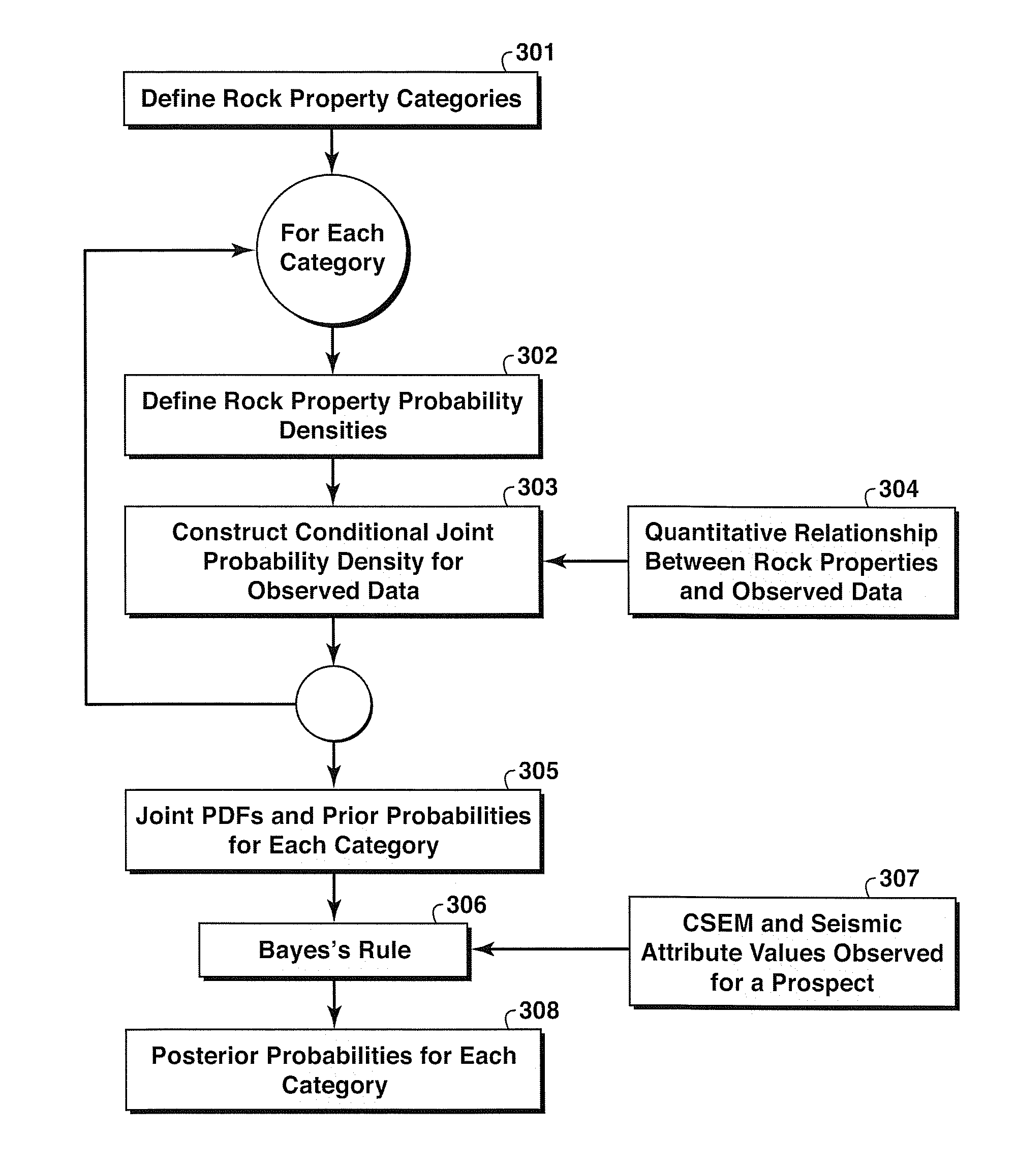
[0052]The following example illustrates the application of the invention to a resistivity anomaly in a modeled CSEM survey where seismic data are used to augment the CSEM data. (The invention is equally well suited for comparing two or more anomaly regions or other target regions from the same survey area.) FIG. 4 is a map of vertical resistivity (magnitude indicated by the gray scale) derived from anisotropic inversion of the modeled CSEM data set. The black lines in FIG. 4 are the transmitter towlines for the modeled survey and the gray spheres are the receiver locations. The input resistivity volume (not shown in the drawings) used to generate the synthetic CSEM data has three high-resistivity (150 Ω-m) layers inside the white polygon 41, embedded in a 12 Ω-m background. The highest inversion resistivity inside the high-resistivity region in FIG. 4 is 36.9 Ω-m, and the horizontal resistivity (not shown) at the same location is 5.1 Ω-m. The seismic interval velocity computed from ...


PUM


Abstract

A probabilistic method for classifying observed CSEM response for a resistive anomaly to classify the response into multiple geologic categories indicative of hydrocarbon production potential. Each category is assigned a prior probability (301). For each category, conditional joint probability distributions for observed CSEM data in the anomaly region are constructed (303) from rock property probability distributions (302) and a quantitative relationship between rock/fluid properties and the CSEM data (304). Then, the joint probability distributions and prior probabilities for each category (305) are combined with observed data (307) and used in Bayes' Rule (306) to update the prior category probabilities (308). Seismic data may be used to supplement CSEM data in the method.

Description

[0001]This application claims the benefit of U.S. Provisional application 61 / 155,408 which was filed on Feb. 25, 2009.FIELD OF THE INVENTION[0002]The invention relates generally to the field of geophysical prospecting and, more particularly, to electromagnetic surveying. Specifically, the invention is a method for classifying potential hydrocarbon reservoirs using electromagnetic survey information.BACKGROUND OF THE INVENTION[0003]Controlled source electromagnetic (CSEM) surveys for mapping subsurface resistivity (Srnka, 2003) have recently come into common use for hydrocarbon exploration. FIG. 1 illustrates a common implementation of CSEM surveying in a marine environment; a different implementation is used for land surveys, but the physical principles involved are the same. A slowly moving (typically 1-2 knots) boat 101 tows a dipole antenna 102 typically 100-300 m in length just above the seafloor 105, driven by a low frequency (typically <10 Hz) high-powered (e.g. 120 kW) sou...

Claims


Application Information

Patent Timeline
Patent Type & Authority Applications(United States)
IPC IPC(8): G01V3/12G01V3/38
CPCG01V3/083G01V3/38G01V3/12
Inventor HOUCK, RICHARD T.
Owner EXXONMOBIL UPSTREAM RES CO
Why Eureka
Try Eureka