Navigation system, method of position estimation and method of providing navigation information

a navigation system and position estimation technology, applied in the field of navigation systems, can solve the problems of inability to accurately provide navigation information, inability to optimize the positioning system of the gps, inability to operate under trees, etc., and achieve the effect of improving the absolute positioning capability of the gps, improving the accuracy of heading, and reducing the number of dead reckonings

Inactive Publication Date: 2013-02-28
CM HK LTD
View PDF12 Cites 24 Cited by
  • Summary
  • Abstract
  • Description
  • Claims
  • Application Information

AI Technical Summary

Benefits of technology

[0035]The advantages of the hybrid-computing navigation system with motion sensor and sensor fusion technology are as follows: this navigation system has more precise dead reckoning, and with the 10-axis capability, absolute positioning capability thereof is more precise than other systems which uses 6-axis only; furthermore, improved accuracy on heading is also achieved; lower infrastructure cost and power consumption can be achieved since conventional Wi-Fi navigation system requires constant periodic Wi-Fi triangulations to be performed thereby requiring more power consumption than the hybrid-computing navigation system with sensor fusion, which only requires lesser number of occasional position updates; and fewer Wi-Fi nodes are required by the hybrid-computing navigation system.
[0036]The benefits of the motion sensor-based algorithm for the hybrid-computing navigation system are as follows: such motion sensor algorithm can coast thru dead zones; it can keep the system alive with sparse Wi-Fi signal; it is able to provide enhanced GPS / AGPS position while the signal is weak; it can also provide indoor / outdoor seamless position transition; and it can be used reliably in more areas; this type of motion sensor-based algorithm allows for the adaptation for Augmented Reality (AR) because implementation of AR needs accurate orientation and position information.

Problems solved by technology

However, GPS is not an optimal positioning system because of having many drawbacks.
For example, some of the drawbacks of the GPS are as follow: GPS does not work well under trees, or inside parking lots and tunnels; and GPS also does not work well under trolley wire, or between tall buildings (in an urban jungle environment), or in bad weather conditions.
Additionally, GPS may have an average position error of about 20-25 meters, which is considered quite significant amount when considered under certain precision positioning applications.
However, such location estimation method ends up with a large variation and deviation in the position and location estimation result.
That is to say, the location estimated by Wi-Fi positioning possesses a large uncertainty.
By comparing the estimated path provided by the Wi-Fi positioning system against the actual walking path of the user, the estimated path obtained by the Wi-Fi positioning has low accuracy.
However, the reduction of positioning error for the improved Wi-Fi positioning system comes at a serious drawback of increased costs as well as higher power consumption at the Wi-Fi receiver carried by the user.

Method used


Image

  • Navigation system, method of position estimation and method of providing navigation information
  • Navigation system, method of position estimation and method of providing navigation information
  • Navigation system, method of position estimation and method of providing navigation information

Examples


Embodiment Construction

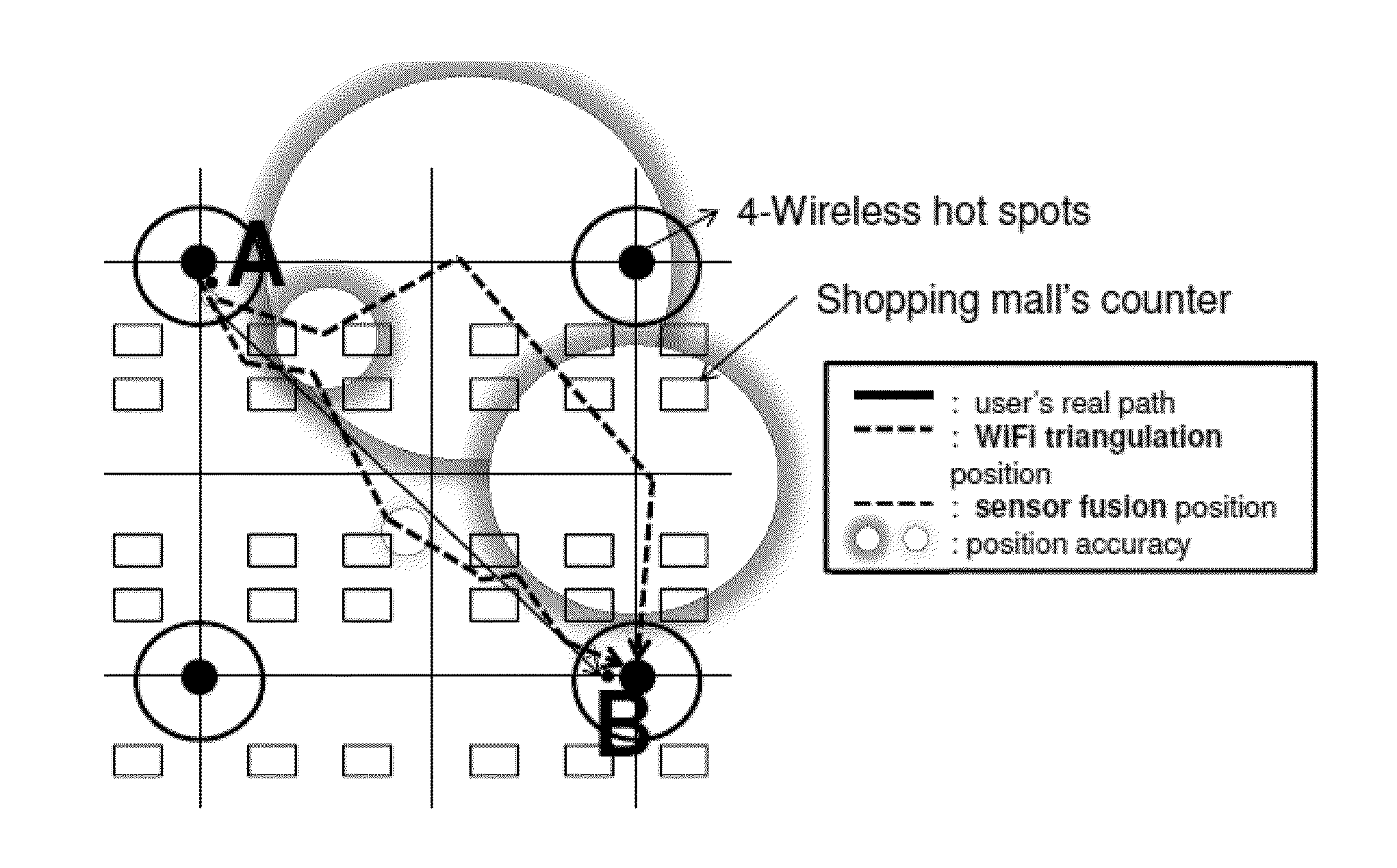
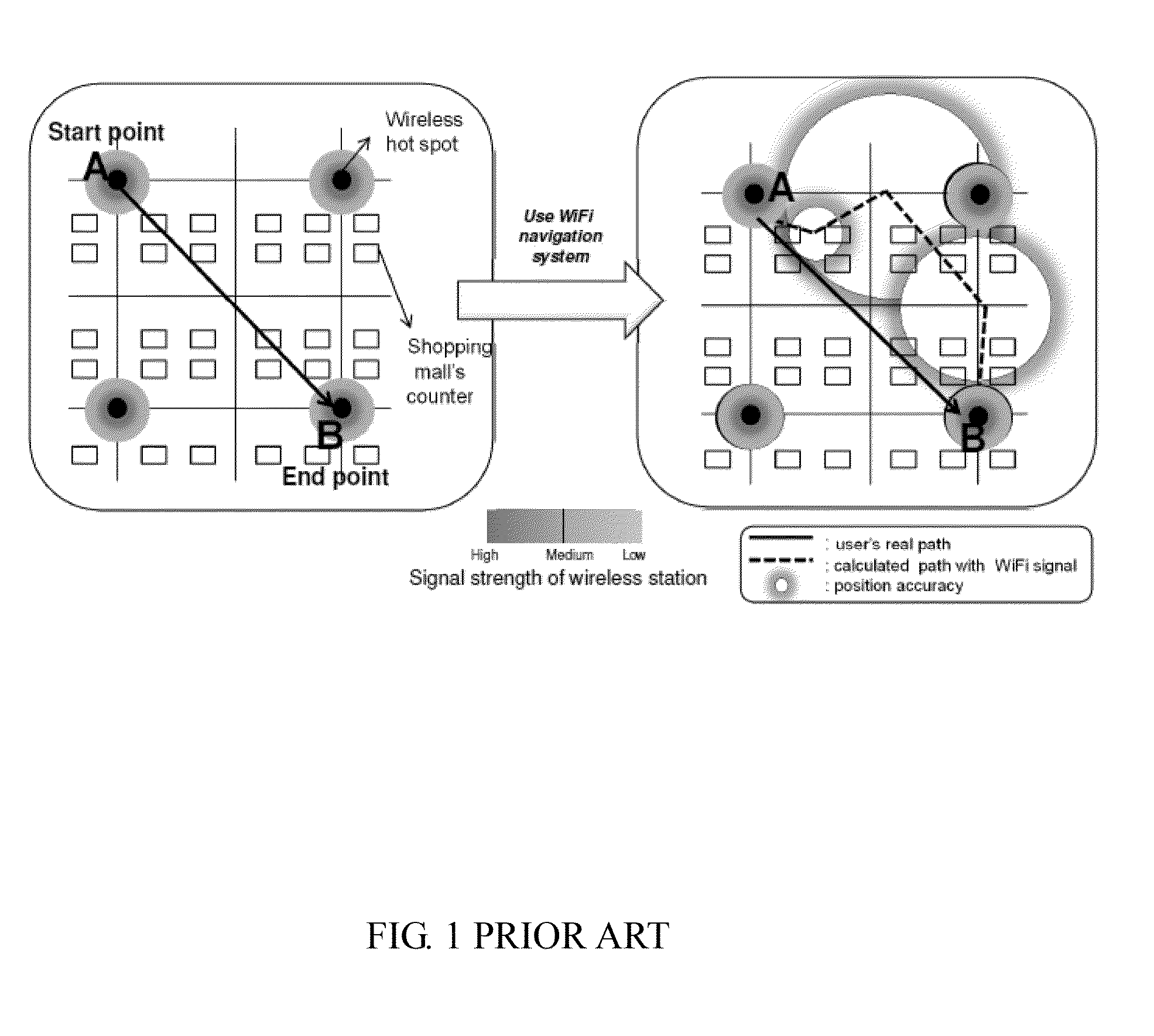
[0037]Referring to FIG. 3, a hybrid-computing navigation system using a conventional configuration of Wi-Fi hot spots incorporating together with a user carrying a Wi-Fi receiver that is configured with 9-axis motion sensors (of 3-axis G, 3-axis Gyro, 3-axis Magnetic) and a 10-axis Sensor Fusion sensor (1-axis Altimeter) according to an embodiment of the present invention is illustrated. FIG. 3 shows the hybrid-computing navigation system being outfitted with 4 Wi-Fi hot spots, and the walking path of the user carrying the Wi-Fi receiver which includes the 9-axis motion sensors and the 10-axis sensor fusion altimeter sensor. Referring to FIG. 3, the dashed line that is shown to be adjacent or very close to the actual path of the user represents the estimated path based upon calculations provided from the hybrid-computing navigation system of Wi-Fi hot spots and the motion sensors of the present invention. The combination of the conventional Wi-Fi positioning system together along wi...


PUM


Abstract

A hybrid-computing navigation system worn by a user includes a modified motion sensor group which includes 9-axis or 10-axis motion sensors that are built-in, and a host device configured for providing navigation information, in which the modified motion sensor group is worn on the user so that a moving direction of the user is the same as a heading direction calculated from the modified motion sensor group. The modified motion sensor group provides step counting and absolute orientation in yaw, roll and pitch using a sensor fusion technique. The navigation system further includes at least one wireless sensor at wifi hot spot to perform sensor fusion for obtaining an absolute position of an estimated position of the user. Sensor fusion combining with location map are used to perform location map matching and fingerprinting. A method of position estimation of a user using the navigation system is also disclosed.

Description

CROSS-REFERENCE TO RELATED APPLICATIONS[0001]This application is a non-provisional of U.S. provisional application Ser. No. 61 / 554,973, filed on Nov. 3, 2011, currently pending, and is a continuation-in-part application of U.S. non-provisional application Ser. No. 13 / 072,794, filed on Mar. 28, 2011, currently pending. The contents of the above-mentioned patent applications are hereby incorporated by reference herein in their entirety and made a part of this specification.BACKGROUND OF THE INVENTION[0002]1. Field of the Invention[0003]The present invention relates to a navigation system, especially to a hybrid-computing navigation system, and method of position estimation utilizing a plurality of motion sensors.[0004]2. Description of Related Art[0005]A number of conventional techniques for determining the position of an electronic device using radio frequency signals are found today. Some popular techniques are directed to the use of the Global Positioning System (GPS), in which mul...

Claims


Application Information

Patent Timeline
Patent Type & Authority Applications(United States)
IPC IPC(8): G01C21/16G06F19/00
CPCG01C21/165G06F3/0346G06F3/0383G01C21/1654
Inventor YE, ZHOULIOU, SHUN-NANLU, YING-KOLEE, CHIN-LUNG
Owner CM HK LTD
Why Eureka
Try Eureka