High speed photometric stereo pavement scanner

Inactive Publication Date: 2013-03-28
RADAR PORTAL SYST
View PDF8 Cites 14 Cited by
  • Summary
  • Abstract
  • Description
  • Claims
  • Application Information

AI Technical Summary

Benefits of technology

[0025]It is therefore an object of the present invention to provide a road surface digitizing system

Problems solved by technology

While manual assessment of these images is quite reliable, automated assessment of the road surface using these images is often quite difficult.
This is partially because road markings, such as oil spills, paint marks, lane markings, tire marks and other road debris, can be easily mistaken for surface distres

Method used


Image

  • High speed photometric stereo pavement scanner
  • High speed photometric stereo pavement scanner
  • High speed photometric stereo pavement scanner

Examples


Embodiment Construction

[0050]The invention is an apparatus and method for collecting a very high resolution digital elevation map and albedo (reflectance) of a surface, at high speed. The purpose of the system is to collect information that allows a more accurate measurement of a road pavement surface. This can then be used to automatically assess road condition, such as cracking, rutting and surface texture.

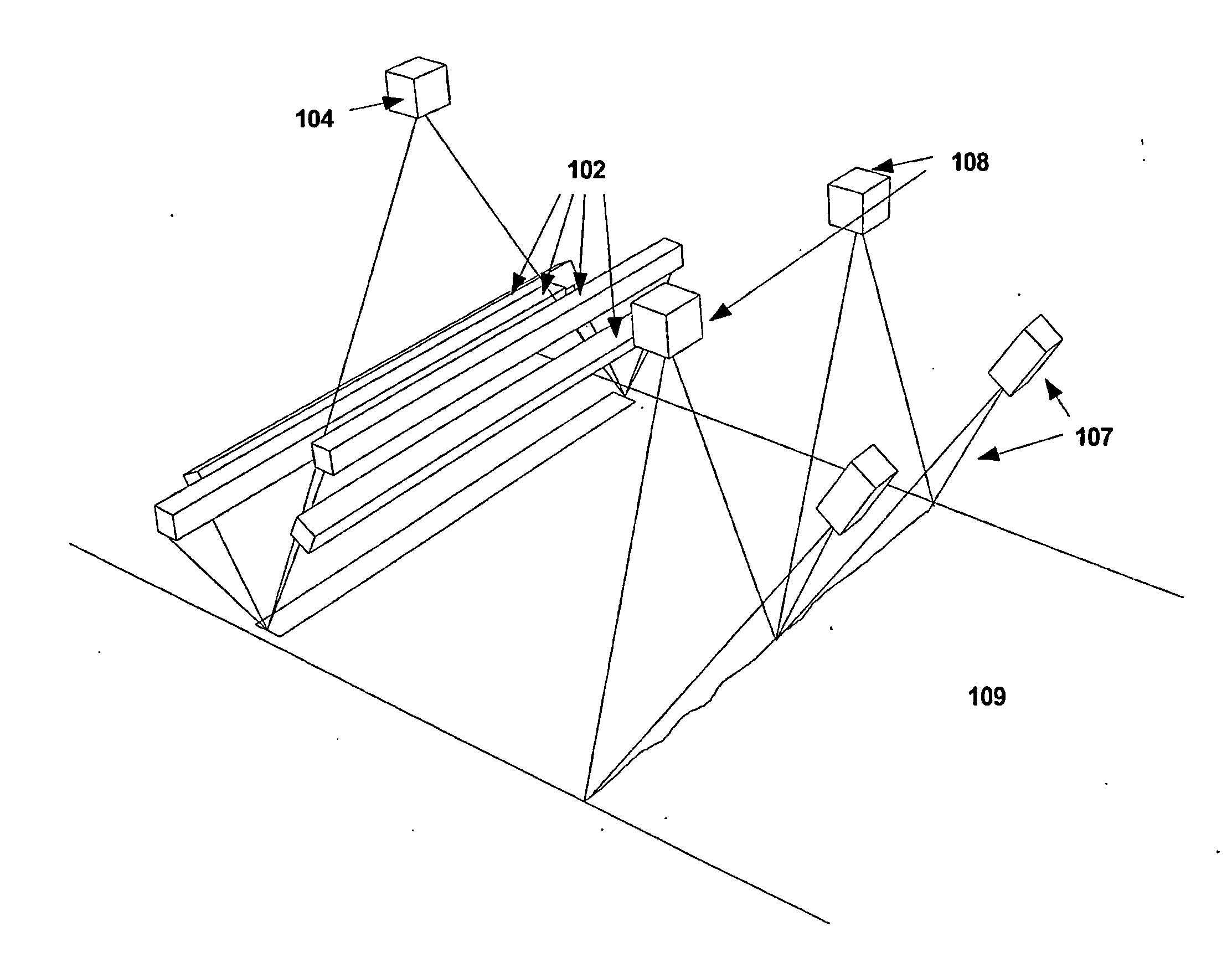
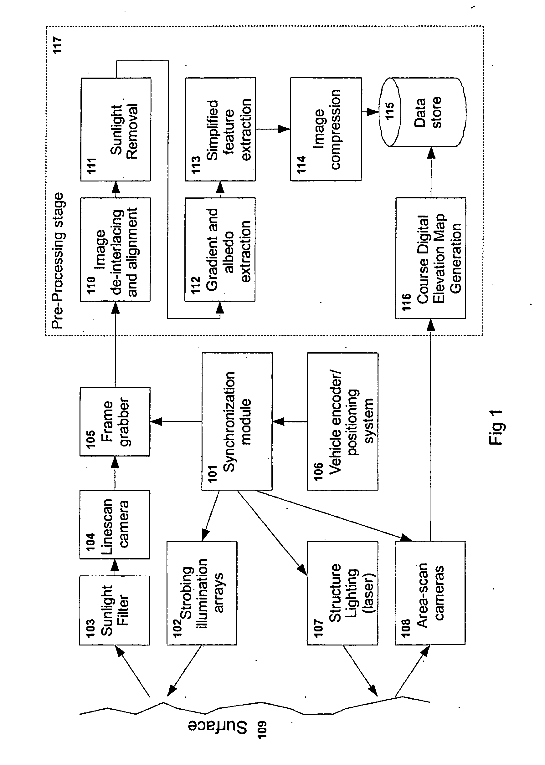
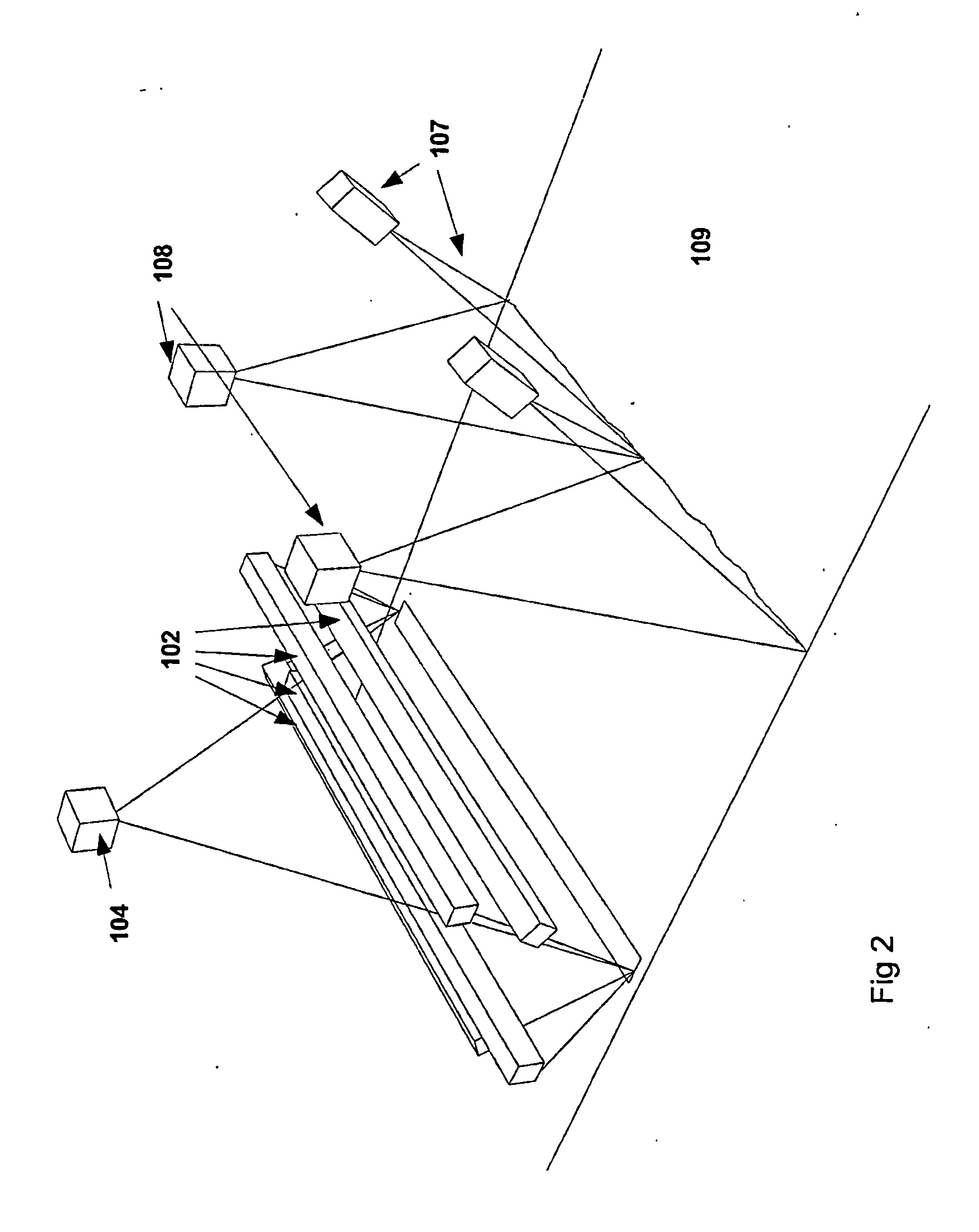
[0051]The proposed system is mounted to a vehicle and comprises a number of elements. FIG. 1 shows a block diagram of these elements:[0052]1) An image capture device which may be a high speed line scan camera 104 and frame grabber 105,[0053]2) A number (suitably four) high brightness array illumination units 102,[0054]3) An encoder mounted to the vehicle allowing movement detection 106,[0055]4) A synchronization module 101,[0056]5) A low resolution digital elevation map (DEM) collection system, such as a structured lighting 107 with a camera system 108. This could alternatively be a LIDAR based laser ...


PUM


Abstract

The invention relates to a pavement scanning system having a movable platform, multiple light sources mounted on the platform for illuminating a pavement surface from multiple different angles, at least one image capture device mounted on the platform that captures sequential images of the illuminated pavement surface and a movement sensor that encodes movement of the platform and provides a synchronization signal for synchronizing the multiple light sources and the at least one image capture device for multiple image capture. The pavement scanning system also includes at least one processor that resamples the multiple captured sequential images to compensate for difference in collection time and calculates surface gradient and albedo for each point on the pavement surface or directly uses the multiple images to detect surface features.

Description

FIELD OF INVENTION[0001]This invention relates to a high speed surface digitization system that allows accurate detection and assessment of surface profiles. The invention can be applied to the assessment of road pavements, bridge decks and airport runways.BACKGROUND OF THE INVENTION[0002]To allow timely maintenance of road pavements, an accurate identification and assessment of road pavement surface distress is required. There are many different modes of distress that can occur, including but not limited to cracking, delamination, disintegration and deformation. Once the type, extent, location and severity of each of these features are assessed, the condition of the road can be determined and remedial measures applied to fix these problems. It is also important to identify areas of both low roughness, which can result in low skid resistance, and high roughness which can result of pavement distress.[0003]Since the early 1970's, a number of systems have been built to allow the assess...

Claims


Application Information

Patent Timeline
IPC IPC(8): G01B11/25
CPCG01B11/2518G01B11/2545G01B11/25
Inventor REEVES, BRYAN
Owner RADAR PORTAL SYST
Why Eureka
Try Eureka