Method and system for creating a current situation depiction

Active Publication Date: 2015-05-07
CONTINENTAL TEVES AG & CO OHG
View PDF15 Cites 5 Cited by
  • Summary
  • Abstract
  • Description
  • Claims
  • Application Information

AI Technical Summary

Benefits of technology

[0014]Expediently, provision is made for the probabilities of existence of the objects to be additionally individually evaluated by a receiving vehicle. Hence, a vehicle receiving the up-to-date situation depiction can use its own onboard sensor system to decide what probability of existence is meant to be attributed to an object or an event. By way of example, the received information can be used to lower the recognition thresholds of particular objects or events in an object or event recognition algorithm of the onboard sensor system.
[0015]Furthermore, it is advantageous that the environment data and/or the map data and/or the position data are sent to the database by the multiplicity of vehicles with comparatively low transmission priority. Hence, the sending and receiving of comparatively important data, such as what are known as “Cooperative Awareness Messages” or warning information, is not disturbed or even interrupted. To produce the up-to-date situation depiction, it is sufficient if the environment data and/or map data and/or position data are not sent to the database in every transmission cycle.
[0016]Preferably, provision is made for the multiplicity of vehicles to send to the database only such environment data and/or map data and/or position data as are different than the up-to-date situation depiction sent by the database. This usually significantly reduces the volume of data to be transmitted, and the transmission capacity of the available transmission channels is not unnecessarily burdened.
[0017]Expediently, provision is made for the position data sent by the multiplicity of vehicles to comprise a piece of identification information for the satellites used for determining the position data. These satellites usually follow fixed paths in an orbit of the earth. Since the satellites are therefore visible from particular points on the earth's surface only at particular times of day, the identification information can be used to ascertain which satellites have been used to determine a particular set of position data. This allows improved position determination, particularly imp

Problems solved by technology

The methods and systems known in the prior art have disadvantages, however, insofar as that the information made available to a driver assistance system by means of vehicle-to-X communication is either limited to a single particular aspect of events on the road, as is the case with traffic light assistants or hazard warnings, for example, or else can

Method used


Image

  • Method and system for creating a current situation depiction
  • Method and system for creating a current situation depiction
  • Method and system for creating a current situation depiction

Examples


Embodiment Construction

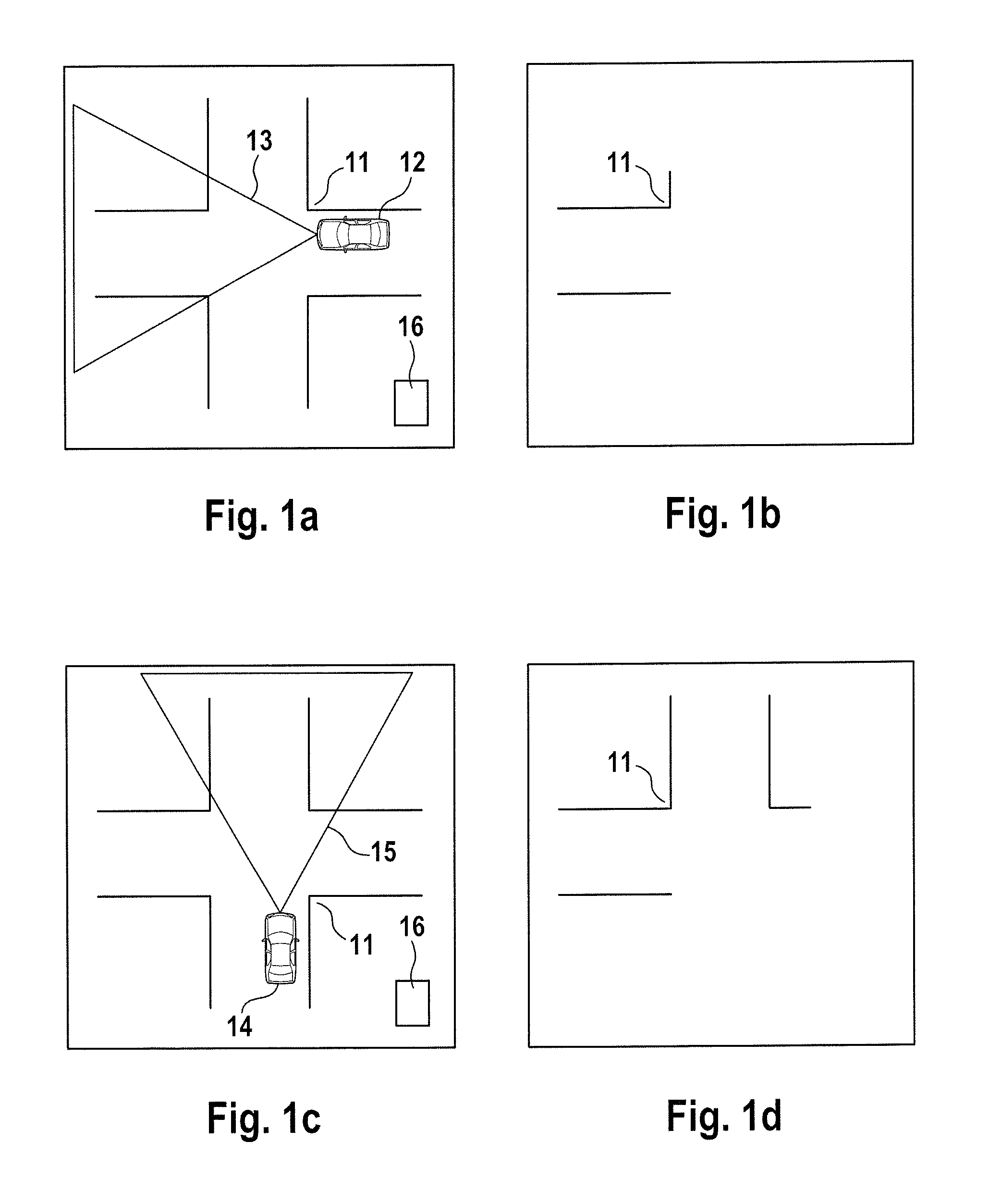
[0044]FIG. 1a schematically shows the junction 11, which vehicle 12 enters from the right. Vehicle 12 is equipped with a camera sensor that senses the conical region 13 of the junction 11.

[0045]The environment data that the conical region 13 comprises are transmitted to the local database 16 by means of vehicle-to-X communication using a WLAN connection. The local database 16 is arranged close to the junction 11 and then contains the information about the junction 11 that is shown in FIG. 1b. Shortly afterward, vehicle 14 enters the junction 11 from below (FIG. 1c). Vehicle 14 is likewise equipped with a camera sensor and uses the camera sensor to sense the conical region 15 of the junction 11. These environment data that the conical region 15 comprises are likewise sent via a WLAN connection to the local database 16, where they are merged with the already existent data. Hence, the database has the up-to-date situation depiction shown in fig. ld available. The position data from veh...


PUM


Abstract

The invention relates to a method for creating a current situation depiction, particularly a current city-centre situation depiction, in which environment data and/or map data and/or position data describing a locally bounded situation are sent to a database by a multiplicity of vehicles using vehicle-to-X communication means. The environment data are captured by means of ambient sensors and/or vehicle sensors, the map data are read from a digital memory, and the position data are determined at least by means of a global satellite position system. The method is distinguished in that the environment data and/or the map data and/or the position data are continually merged with a situation depiction that is already present in the database to form a current situation depiction, and both the database and the situation depiction are fixed in location. The invention also relates to an appropriate system.

Description

CROSS REFERENCE TO RELATED APPLICATIONS[0001]This application is the U.S. National Phase Application of PCT International Application No. PCT / EP2013 / 059397, filed May 6, 2013, which claims priority to German Patent Application No. 10 2012 208 254.9, filed May 16, 2012, the contents of such applications being incorporated by reference herein.FIELD OF THE INVENTION[0002]The invention relates to a method for producing an up-to-date situation depiction and to a system for producing an up-to-date situation depiction.BACKGROUND OF THE INVENTION[0003]The prior art discloses different kinds of driver assistance systems that have the essential common feature that they serve to relieve the driver of duties pertaining to events on the road. In this case, such systems are based to some extent on environment information captured by means of ambient sensor systems, on information read from digital map material or else on information that has been received by means of vehicle-to-X communication. I...

Claims


Application Information

Patent Timeline
IPC IPC(8): G08G1/01G08G1/0967
CPCG08G1/0112G08G1/096741G08G1/096775G01C11/04
Inventor STRAUMATTHIASSTAHLIN, ULRICH
Owner CONTINENTAL TEVES AG & CO OHG
Why Eureka
Try Eureka