Method for automatically extracting structural framework from potential field data

a potential field and structural framework technology, applied in the direction of reradiation, instruments, image enhancement, etc., can solve the problems of low accuracy of analysis results, inability to obtain complete and accurate anomaly boundary locations, and anomaly differences, so as to increase the range of magnetic anomalies, effectively identify and establish magnetic structural frameworks

Active Publication Date: 2018-02-22
INST OF MINERAL RESOURCES CHINESE ACAD OF GEOLOGICAL SCI
View PDF5 Cites 9 Cited by
  • Summary
  • Abstract
  • Description
  • Claims
  • Application Information

AI Technical Summary

Benefits of technology

[0019]Further, total horizontal derivatives of tilt derivatives (TDR) and analytic signals of TMI anomaly data are not influenced by magnetic inclination, calculation results are not related to the magnitude of magnetic inclination, and calculation of total derivatives of TDR and analytic signals may be directly performed to TMI anomaly data without reduction-to-pole processing. However, calculation results of analytic signal method may increase the range of magnetic anomalies, loss geological structure attitude information and structure zoning information and be not sensitive to identification of geological structures. However, current results of total horizontal derivatives of tilt derivatives are expressed in form of grid images or contour maps, and useful information for geological interpretation and mineral exploration such as st

Problems solved by technology

However, geological structures controlling the formation of ore deposits can produce anomaly differences.
These methods have problems of being not sensitive to directional information, and cannot obtain complete and accurate anomaly boundary locations.
However, this method still has the following problems: (1) the edges obtained through calculation are not single-pixel point width, actual geographical ranges corresponding to the edges and the intersections of the edges in different directions are large, which causes the accuracy of analysis result not high; (2) a three-dimensional structural map of shallow crusts is obtained by artificial vectorization to different scales of edges and taking connection lines of edge centers as anomaly boundaries, which causes a low working efficiency; (3) the three-dimensional structural map of shallow crusts shows only information about structures at different depths, cannot reflect lithological changes of structural belts and of the two sides, and cannot indicate deformation and act

Method used


Image

  • Method for automatically extracting structural framework from potential field data
  • Method for automatically extracting structural framework from potential field data
  • Method for automatically extracting structural framework from potential field data

Examples


embodiment 1

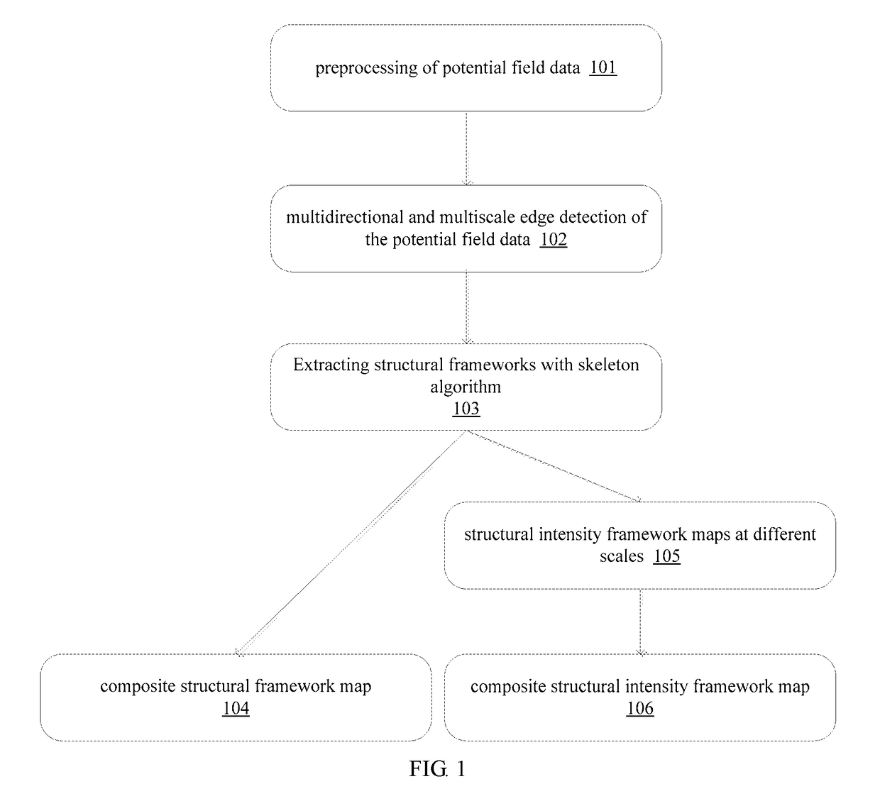
[0096]FIG. 1 illustrates a flowchart of a method for automatically extracting a structural framework from potential field data according to Embodiment 1 of the present invention. As illustrated in FIG. 1, the method comprises the following steps:

[0097]In step 101, preprocessing is performed to the measured gravity potential field data or magnetic potential field data.

[0098]Reduction-to-pole calculation is performed to the magnetic data to obtain the reduction-to-pole magnetic anomalies or pseudo-gravity transformation is applied to obtain pseudo-gravity anomalies.

[0099]Preprocessing is performed to the gravity data to obtain Bouguer gravity anomalies.

[0100]In step 102, a potential field multidirectional and multiscale edge detecting method is applied to the preprocessed gravity potential field data or magnetic potential field data to obtain edges at a plurality of scales.

[0101]The potential field multidirectional and multiscale edge detecting method comprises steps of upward continu...

example 1

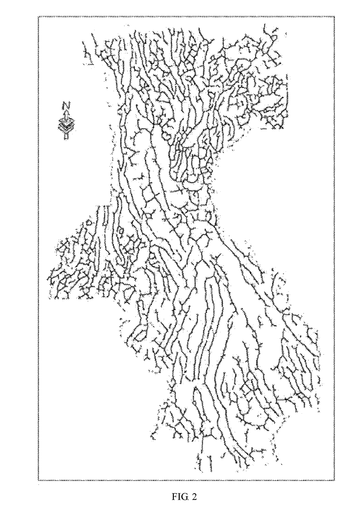
[0135]The technical solution of the present invention will be explained by taking automatic extraction of a potential field structural framework from aeromagnetic data of West Yunnan as an example.

[0136]Firstly, reduction-to-pole processing is performed in blocks to the aeromagnetic data, the processed data are spliced to form a potential field grid file and the size of the grid is 500 m. The aeromagnetic data in this example is historical one measured and collected in the past in many times, and the measurement height is in range of 800-1200 m.

[0137]Then, upward continuation processing is respectively performed to the spliced potential field grid file to obtain potential field data after upward continuation, the upward continuing heights are 1000 m, 1500 m, 2000 m, 2500 m, 3000 m, 4000 m, 5000 m, 10000 m, 15000 m, 20000 m, 25000 m and 30000 m, respectively, edge detections in thirty-two directions are applied at each upward continued height, each direction a is taken a value as kπ / ...

embodiment 2

[0146]A flowchart of a method for automatically extracting a magnetic structural framework of a low-latitude area according to Embodiment 2 of the present invention will be specially described below by taking magnetic measure data as an example. One skilled in the art can understand that the method provided by the present invention is not limited to be applicable to automatic extraction of structural frameworks from magnetic survey data and is also applicable to automatic extraction of structural frameworks from gravity measure data.

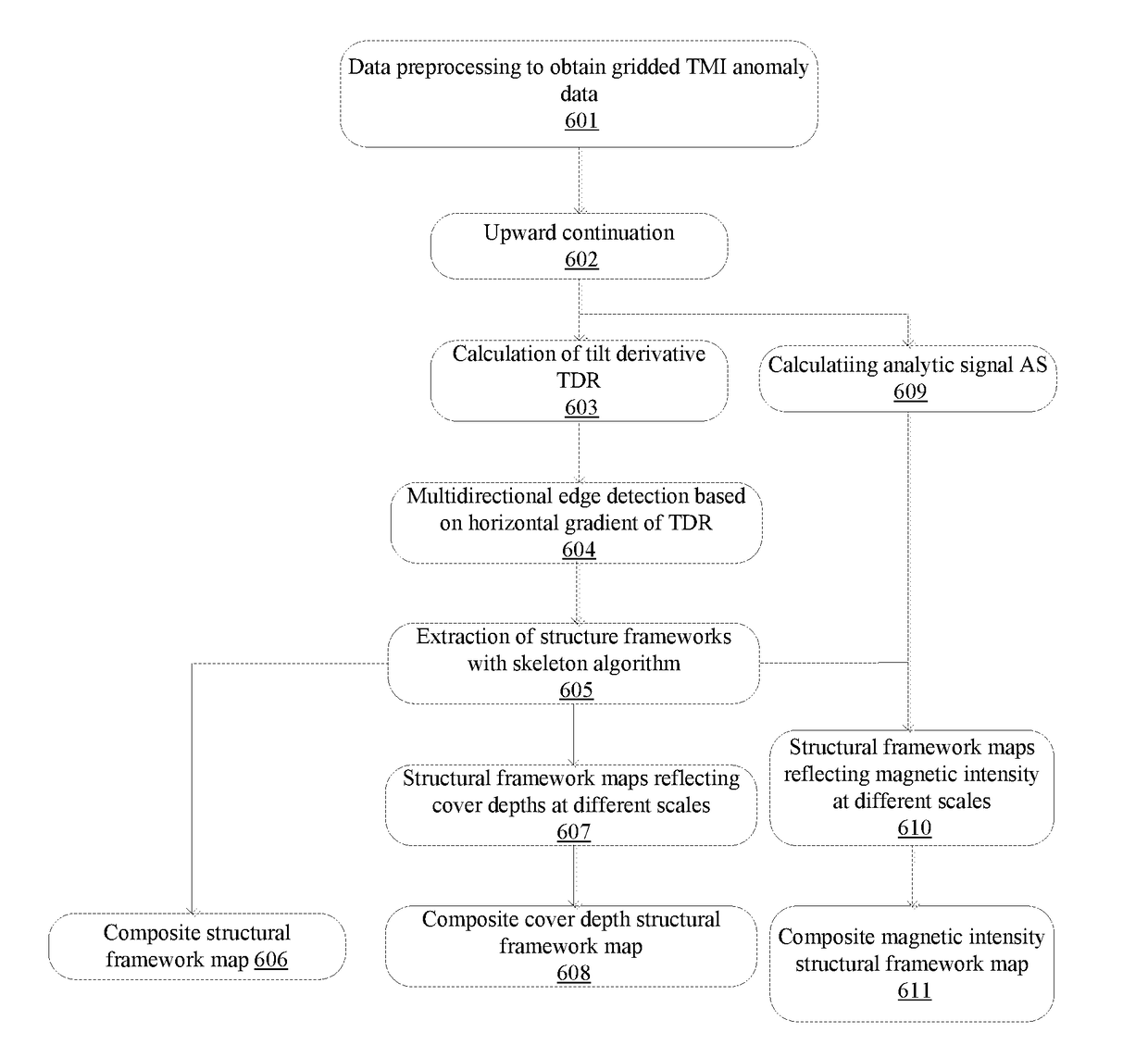
[0147]FIG. 6 illustrates a flowchart of a method for automatically extracting a magnetic structural framework from a low-latitude area according to the present invention. As illustrated in FIG. 6, the method comprises the following steps:

[0148]In step 601, preprocessing is performed to measurement values obtained through magnetic survey, and Normal Geomagnetic Field (IGRF International Geomagnetic Reference Field) correction is performed to obtain Total ...


PUM


Abstract

A method for automatically extracting a tectonic framework of a potential field includes preprocessing gravity potential field data and/or magnetic potential field data from an area to be researched; performing multi-scale and multi-direction edge detection on the preprocessed gravity potential field data and/or magnetic potential field data, and obtaining edges of all scales separately; thinning the calculated edge of each scale into a single pixel width by means of a morphological skeleton algorithm, each point having depth and strength attributes; and obtaining a comprehensive tectonic framework graph and a comprehensive tectonic strength framework graph. A geological structure formed by a control deposit can be identified and qualitatively interpreted, a potential deposit type and attributes of the structure are determined according to prior knowledge of an area to be researched, and different types of tectonic frameworks are screened, thereby achieving target area localization of a metal deposit.

Description

FIELD OF THE INVENTION[0001]The present invention relates to a method for automatically extracting structural framework from gravity potential field data and magnetic potential field data, which is a technique for detecting geological structure based on gravity anomaly data and magnetic anomaly data. More specifically, the present invention is in the fields of wavelet analysis, image processing, geophysics, geology and mineral exploration. The method of the present invention can be directly applied to the fields of mineral exploration and related geological survey.BACKGROUND[0002]With the development of airborne geophysical exploration technology, gravity and magnetic (hereunder called as “gravity-magnetic”) measurement methods have the advantages of economy, rapidness and covering landscape areas which are difficult to reach, and play a more and more important role in exploration and evaluation of metal ore deposits. Especially, with the development of high-precision aeromagnetic s...

Claims


Application Information

Patent Timeline
IPC IPC(8): G01V11/00G01V3/38G01V7/06
CPCG01V11/002G01V3/38G01V7/06G06T17/05G06T7/13G06T2207/20182G01V3/081G06T2207/20016G06T2207/20044G06T2207/20064G06T2207/30181
Inventor CAO, DIANHUA
Owner INST OF MINERAL RESOURCES CHINESE ACAD OF GEOLOGICAL SCI
Why Eureka
Try Eureka