Imaging near-borehole structure using directional acoustic-wave measurement

a near-borehole and directional acoustic wave technology, applied in the field of drilling and logging borehole systems, can solve the problems of limiting the horizontal reach, severe dogleg paths along the way, and prior art downhole lack of providing such information, so as to minimize the cost function

Active Publication Date: 2006-04-25
BAKER HUGHES INC
View PDF16 Cites 87 Cited by
  • Summary
  • Abstract
  • Description
  • Claims
  • Application Information

AI Technical Summary

Benefits of technology

[0014]On the migrated sections, the relative dip may be easily obtained by fitting a line to a linear trend on one of said plurality of migrated image data sections. The a

Problems solved by technology

Lack of such information can lead to severe “dogleg” paths along the borehole resulting from hole or drill path corrections to find or to reenter the payzones.
Such wellbore profiles usually limit the horizontal reach and the final wellbore length exposed to the reservoir.
Steering efficiency and geological positioning are considered in the industry among the greatest limitations of the current drilling systems for drilling horizontal and complex wellbores.
Prior art downhole lack in providing such information during drilling of the boreholes.
Resistivity measurements do not provide bed boundary information relative to the downhole subassembly.
Furthermore, error margin of the depth-measuring devices, usually deployed on th

Method used


Image

  • Imaging near-borehole structure using directional acoustic-wave measurement
  • Imaging near-borehole structure using directional acoustic-wave measurement
  • Imaging near-borehole structure using directional acoustic-wave measurement

Examples


Embodiment Construction

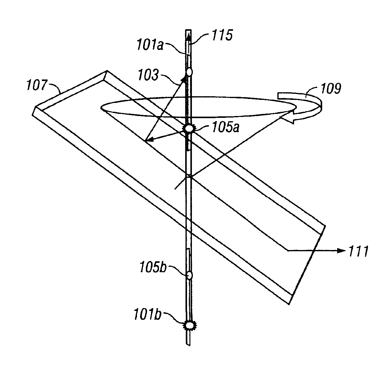
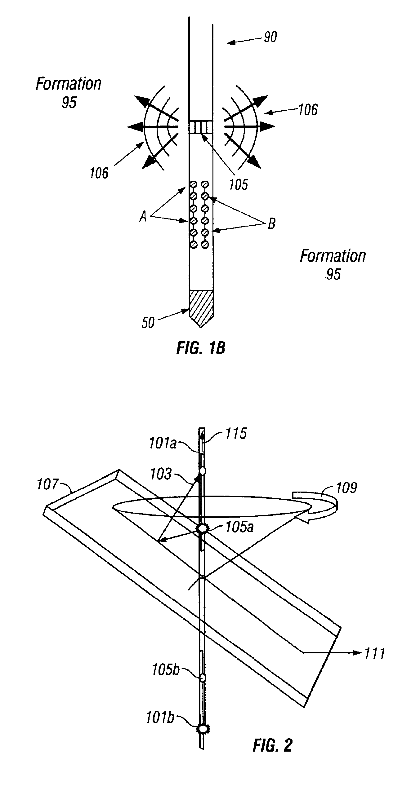
[0027]The present invention is a method, system and apparatus for imaging of bed boundaries in an earth formation. To the extent that the following description is specific to a particular embodiment or a particular use of the invention, this is intended to be illustrative and is not to be construed as limiting the scope of the invention. The embodiment of the invention is described with reference to a measurement-while-drilling configuration. This is not to be construed as a limitation, and the method of the present invention can also be carried out in wireline logging.

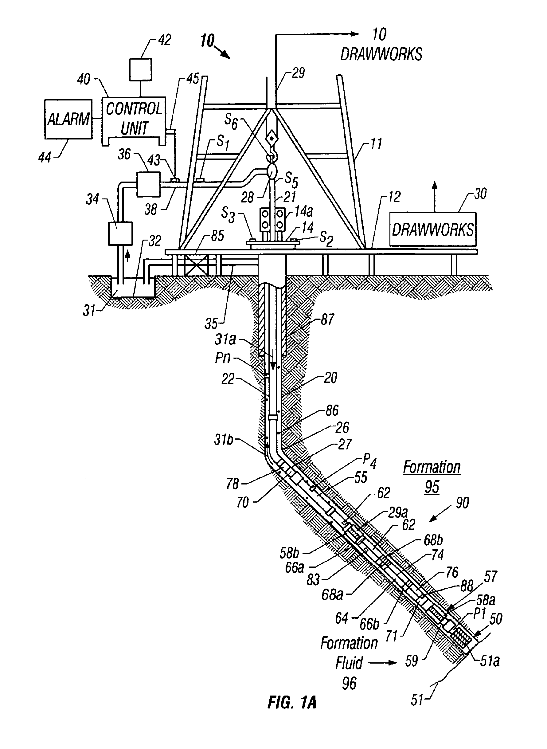
[0028]FIG. 1A shows a schematic diagram of a drilling system 10 having a bottom hole assembly (BHA) or drilling assembly 90 that includes sensors for downhole wellbore condition and location measurements. The BHA 90 is conveyed in a borehole 26. The drilling system 10 includes a conventional derrick 11 erected on a floor 12 which supports a rotary table 14 that is rotated by a prime mover such as an electric motor (no...


PUM


Abstract

Directional acoustic measurements made in the borehole are used for imaging a near-borehole geological formation structure and determination of its orientation. Four-component cross-dipole data set measured in a deviated borehole in combination with the directionality of the compressional waves in the dipole data give the orientation of bed boundaries crossing the borehole. The low-frequency content (2˜3 kHz) of the data allows for imaging the radial extent of the formation structure up to 15 m, greatly enhancing the penetration depth as compared to that obtained using conventional monopole compressional-wave data. A combination monopole/dipole arrangement of sources and receivers may also be used for imaging of bed boundaries.

Description

BACKGROUND OF THE INVENTION[0001]1. Field of the Invention[0002]This invention relates generally to systems for drilling and logging boreholes for the production of hydrocarbons and more particularly to a drilling system having an acoustic measurement-while-drilling (“MWD”) system as part of a bottomhole assembly, or an after-drilling wiereline logging system having an acoustic device for measuring acoustic velocities of subsurface formations during or after drilling of the wellbores and determining the location of formation bed boundaries around the bottomhole assembly, as in the MWD system, or around the wireline logging system. Specifically, this invention relates to the imaging of bed boundaries using directional acoustic sources. For the purposes of this invention, the term “bed boundary” is used to denote a geologic bed boundary, interface between layers having an acoustic impedance contrast, or a subsurface reflection point. For the purposes of this invention, the term acoust...

Claims


Application Information

Patent Timeline
IPC IPC(8): G01V1/30G01V1/28E21B47/026G01V1/44
CPCG01V1/44E21B47/026G01V1/48E21B47/0224
Inventor TANG, XIAO MING
Owner BAKER HUGHES INC
Why Eureka
Try Eureka