Unit and program for displaying map

a map and program technology, applied in traffic control systems, navigation instruments, instruments, etc., can solve the problems of wasting a lot of time, too low follow-up capability to catch up the display, and jpeg compressed data decompression with high compressibility takes a long tim

Inactive Publication Date: 2007-04-03
AISIN AW CO LTD
View PDF15 Cites 21 Cited by
  • Summary
  • Abstract
  • Description
  • Claims
  • Application Information

AI Technical Summary

Benefits of technology

[0011]The invention has been made to address the above problems. Accordingly, an object of the invention is to allow smooth scrolling of a map display using compressed data without delay in the display.

Problems solved by technology

The process for decompressing JPEG compressed data with high compressibility takes a lot of time, thus posing the problem of too low follow-up capability to catch up the display when the current location is tracked and scrolled using the satellite photograph data displayed by a car navigation system.
However, it takes a lot of processing time to change colors using the color palette, thus having the problem of taking a long time particularly when the number of colors to be changed is large.
The system, however, has the problem of requiring a storage medium for storing two pieces of satellite photograph data on the same location thereby increasing the cost of the entire system.

Method used


Image

  • Unit and program for displaying map
  • Unit and program for displaying map
  • Unit and program for displaying map

Examples


Embodiment Construction

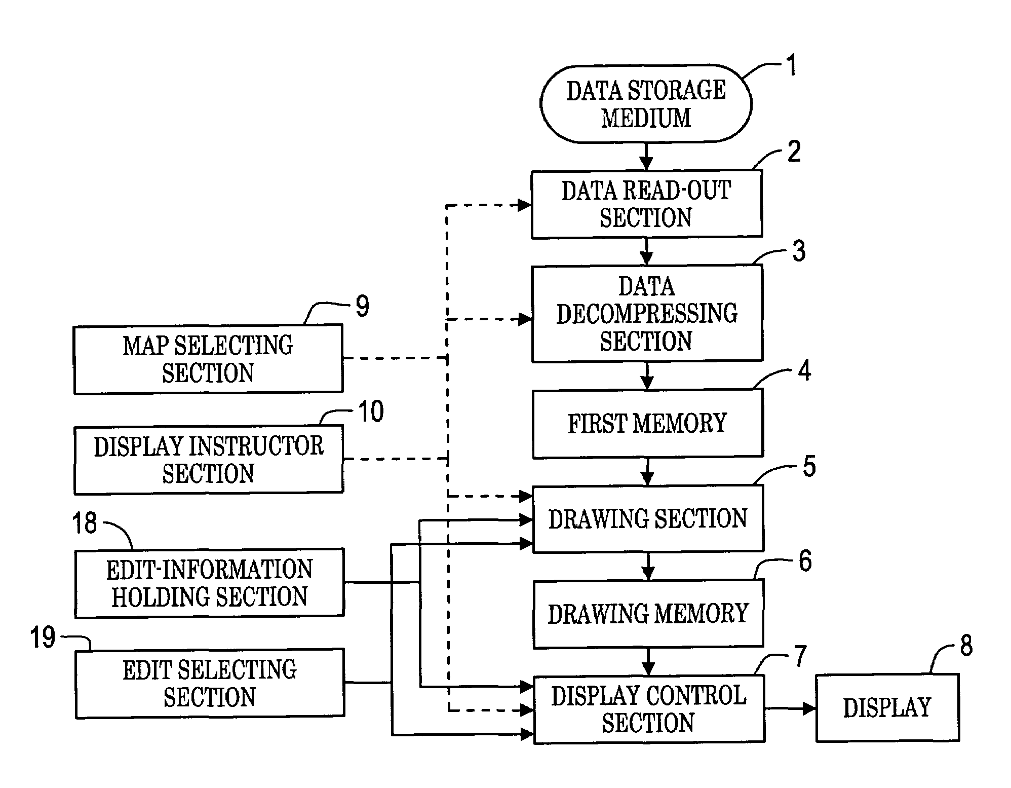
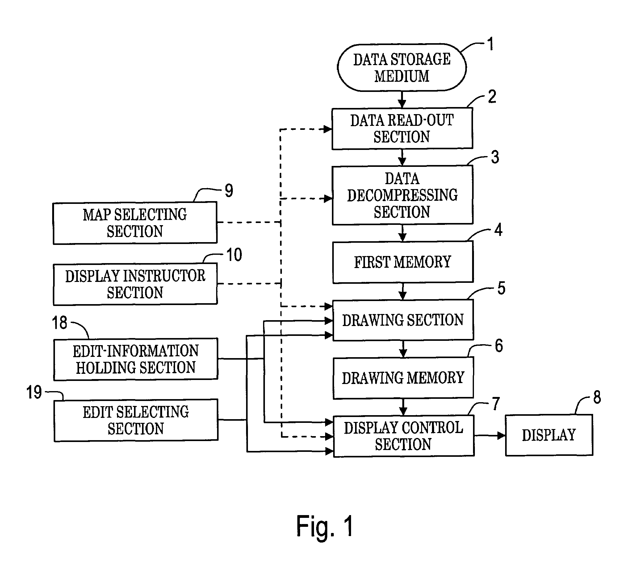
[0049]In the drawings, reference numeral 1 denotes a data storage medium; numeral 2 denotes a data read-out section; numeral 3 denotes a data decompressing section; numeral 4 denotes a first memory; numeral 5 denotes a drawing section; numeral 6 denotes a drawing memory; numeral 7 denotes a display control section; numeral 8 denotes a display; numeral 9 denotes a map selecting section; numeral 10 denotes a display instructor section; numeral 18 denotes an edit-information holding section; and numeral 19 denotes an edit selecting section.

[0050]Referring to FIG. 1, the data storage medium 1 stores map data to be displayed. The data storage medium 1, for purposes of description, is, but is not limited to, a disc (external storage medium) for storing various map data including compressed map data, such as JPEG satellite photograph data with high compressibility, and uncompressed map data. Other ways of providing stored map data to the system would be known to those skilled in the art. T...


PUM


Abstract

The invention provides a map display unit including a first memory for storing map data and a drawing memory for drawing the map data and displaying display-area data and a display. The map display unit includes a unit to read and decompress compressed map data stored in blocks in a data storage medium and to store the decompressed map data in the first memory; a unit to draw the stored map data in the drawing memory; and a unit to determine the display area and to display the display-area data of the drawing area in the drawing memory on the display. When there is no display-area data in the first memory, compressed map data is read and decompressed from the data storage medium by the data decompression unit. The map display unit further includes an environmental change sensor and controllers to vary the color tone of the map data with the environmental change, thereby displaying easily viewable map data.

Description

[0001]The disclosure of Japanese Patent Application No. 2002-232831 filed on Aug. 9, 2002 and No. 2002-232830 filed on Aug. 9, 2002 including the specification, drawings and abstract are incorporated herein by reference in their entirety.BACKGROUND OF THE INVENTION[0002]1. Field of Invention[0003]The invention relates to a unit and a program for displaying a map, the unit including a first memory for storing map data and a drawing memory for drawing the map data and displaying display-area data of a drawing area in the drawing memory on a display while editing the map in accordance with selected edit information.[0004]2. Description of Related Art[0005]In navigation systems, a map scroll operation is performed on a screen to display a simulation route from the current location to a destination on a map screen in sequence, to track-display the current location with the actual traveling, and to set a starting point, a destination, and a detour on the map.[0006]For example, there have ...

Claims


Application Information

Patent Timeline
Patent Type & Authority Patents(United States)
IPC IPC(8): G06F13/00G06T9/00G01C21/32G01C21/36G08G1/0969
CPCG01C21/32G01C21/367G01C21/3673G08G1/0969G01C21/3852
Inventor OGAWA, TSUYOSHI
Owner AISIN AW CO LTD
Why Eureka
Try Eureka