Wireless CPU GPS application

a wireless cpu and application technology, applied in the direction of direction finders using radio waves, instruments, measurement devices, etc., can solve problems such as inability to solve, and achieve the effect of easy porting and product migration

Inactive Publication Date: 2008-12-09
FURUNO ELECTRIC CO LTD +1
View PDF4 Cites 52 Cited by
  • Summary
  • Abstract
  • Description
  • Claims
  • Application Information

AI Technical Summary

Benefits of technology

[0013]Briefly, a wireless handheld GPS-enabled device and supporting system embodiment of the present invention comprises a wireless CPU that functions as a host processor, a GPS chipset to provide GPS measurements, and a GPS application hosted by the wireless CPU. Other applications are also hosted by the wireless CPU and are provided with position solutions from the GPS application. The GPS application calls for GPS aiding information from an Internet server via a TCP / IP socket provided by a GPRS link supported by the wireless CPU. Location area identifier (LAI) and “breadcrumb” information are provided to the GPS application so it can skip having to make a z-count determination during initialization.
[0015]A further advantage of the present invention is that a modular structure is provided in which the module interconnections use standardized serial and AT-command interfaces that provide for easy porting and product migration.

Problems solved by technology

It is not considered an autonomous satellite positioning system (GPS) receiver because the hardware can only measure the fractional part of the total range.
Such effect is different on each satellite and occasionally it is impossible to resolve if the position error exceeds 75-km.

Method used


Image

  • Wireless CPU GPS application
  • Wireless CPU GPS application
  • Wireless CPU GPS application

Examples


Embodiment Construction

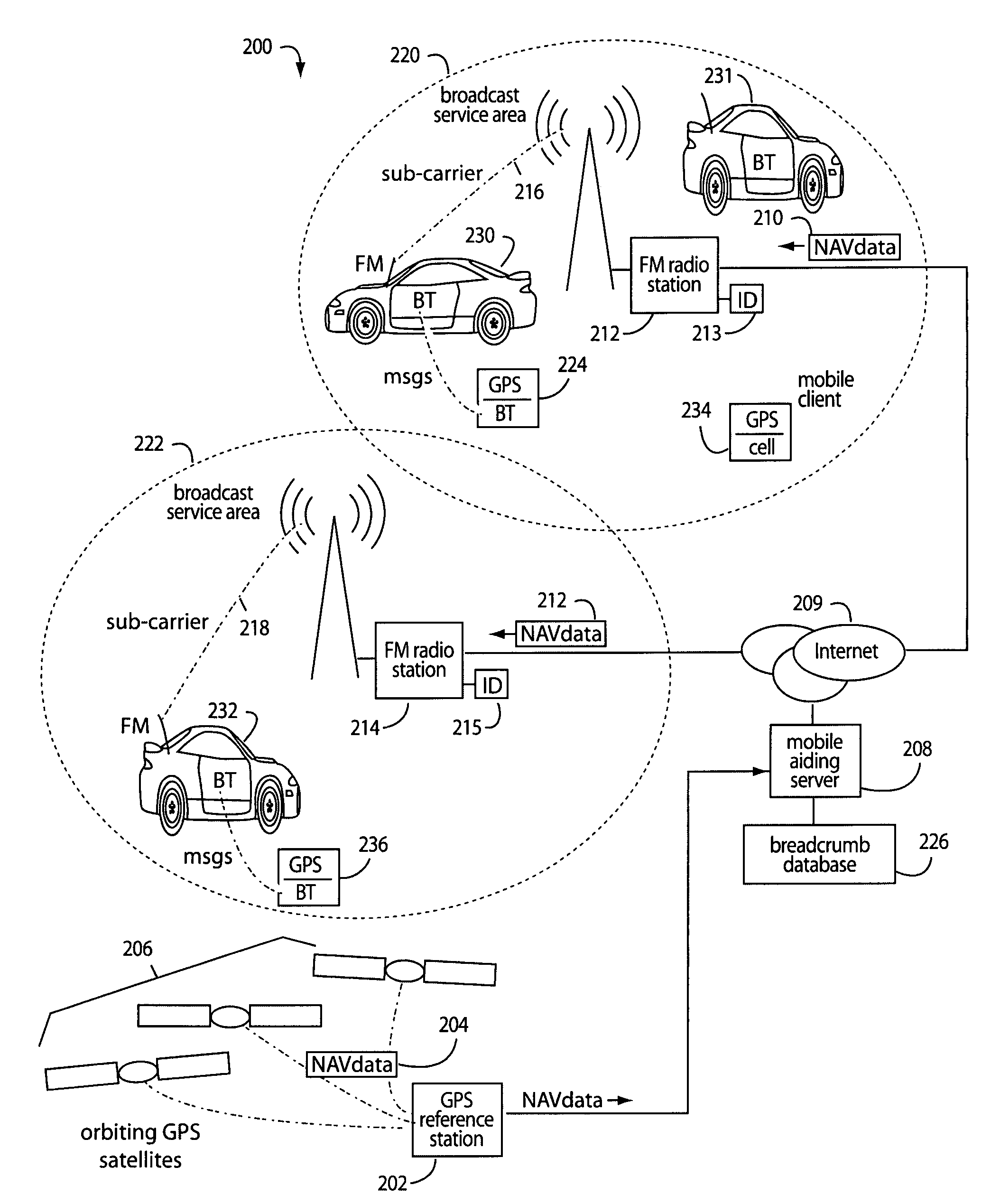
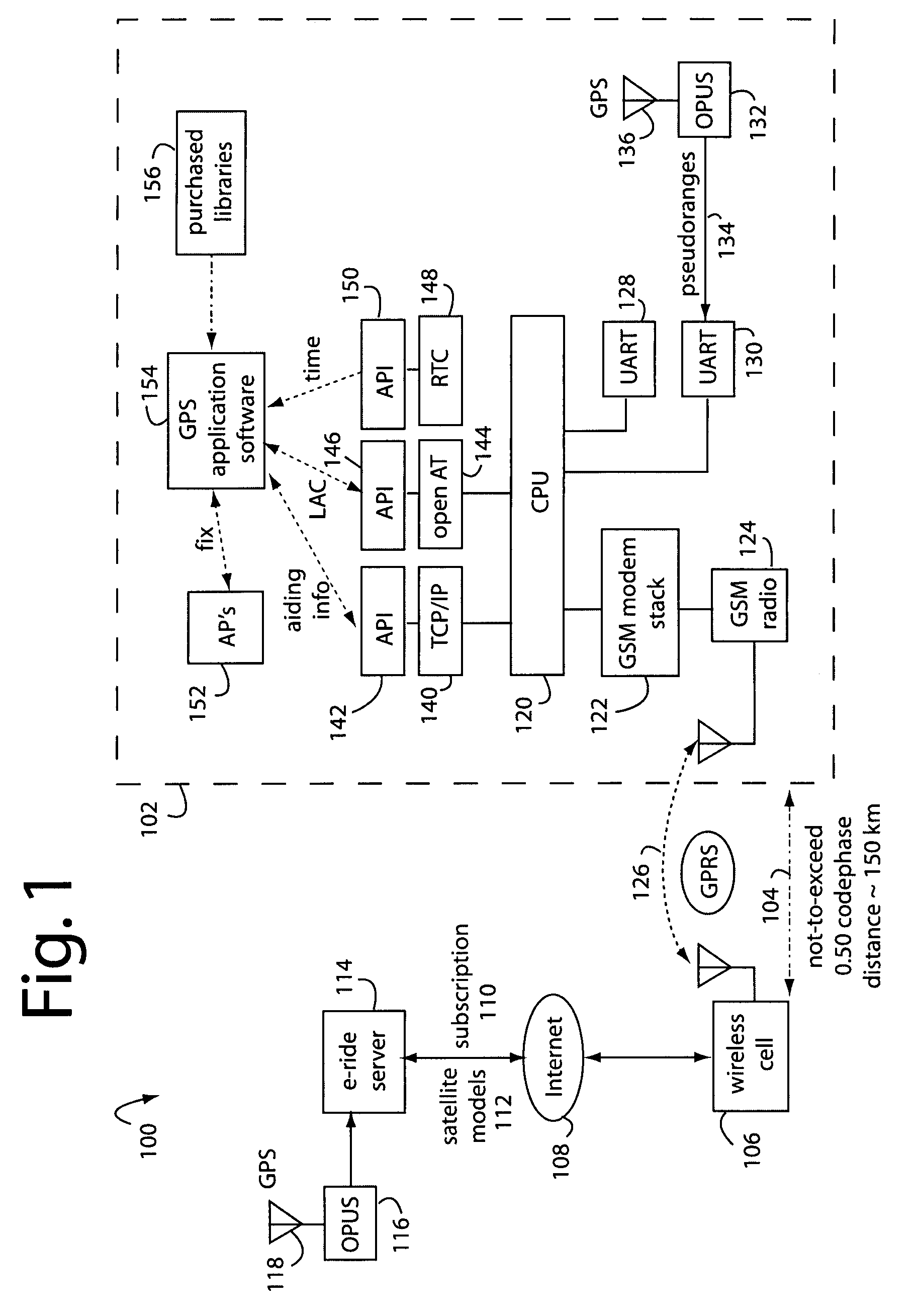
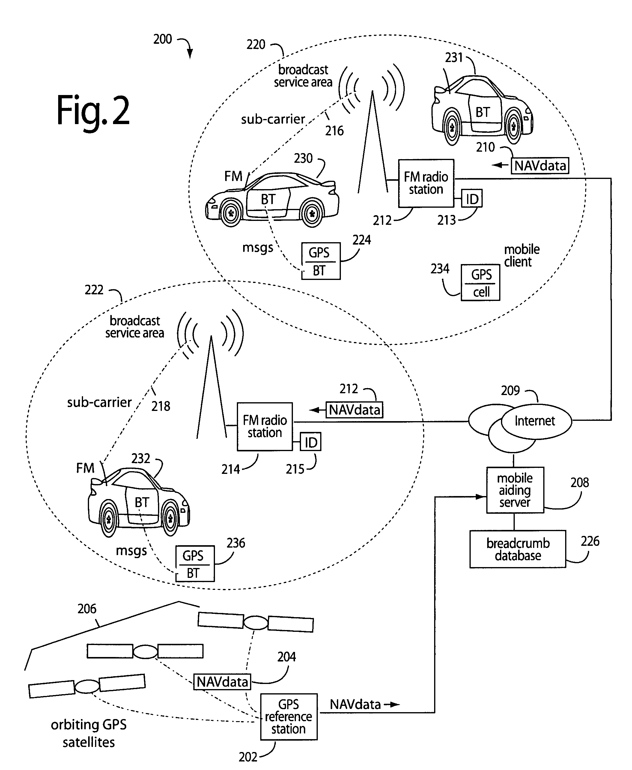
[0023]FIG. 1 represents a mobile GPS-aiding system embodiment of the present invention, and is referred to herein by the general reference numeral 100. System 100 comprises a wireless handheld device 102 that operates within a not-to-exceed (NTE) distance 104 of a local wireless cell base station 106. The NTE distance is limited by one-half the codephase propagation distance of global positioning system (GPS) coarse acquisition (C / A) code satellite transmissions, approximately one hundred fifty kilometers (150-km). Such local wireless cell base station 106 is associated with a location area identifier (LAI) identifier that hints at its geographical position, e.g., “415” for San Francisco, Calif. The typical service area of a local wireless cell base station 106 is usually no more than fifty kilometers in diameter, easily satisfying the NTE distance 104. As the wireless handheld device 102 roams, it will find and work with the nearest of other local wireless cell base stations 106 th...


PUM


Abstract

A wireless handheld GPS-enabled device and supporting system comprises a wireless CPU that functions as a host processor, a GPS chipset to provide GPS measurements, and a GPS application hosted by the wireless CPU. Other applications are also hosted by the wireless CPU and are provided with position solutions from the GPS application. The GPS application calls for GPS aiding information from an Internet server via a TCP / IP socket provided by a GPRS link supported by the wireless CPU. Location area identifier (LAI) and “breadcrumb” information are provided to the GPS application so it can skip having to make a z-count determination during initialization.

Description

FIELD OF THE INVENTION[0001]The present invention relates to global positioning system (GPS) receivers, and more particularly to portable wireless devices with host processors running many applications including GPS.DESCRIPTION OF THE PRIOR ART[0002]Mobile, portable GPS receivers are often turned on after many hours or days of being turned off. And when they are turned on, the users expect immediate results. But the receivers can be in a very different place than they were during the last position fix. Portable GPS receivers can produce much quicker initial position solutions, and save precious battery power, if they are immediately provided satellite model data, a close estimate of time, and the current general location.[0003]If the rough location information is good to within half of the pseudorandom noise (PRN) codephase propagation distance, e.g., 150-km, then the integer ambiguities in the z-count do not have to be solved immediately, and the GPS-millisecond system-time will be...

Claims


Application Information

Patent Timeline
Patent Type & Authority Patents(United States)
IPC IPC(8): G01S3/02G01S19/25
CPCG01S19/06G01S19/235G01S19/252G01S19/258
Inventor MCBURNEY, PAUL W.
Owner FURUNO ELECTRIC CO LTD
Why Eureka
Try Eureka