Airborne radar having a wide angular coverage, notably for the sense-and-avoid function

a radar and wide angular coverage technology, applied in the direction of reradiation, measurement devices, instruments, etc., can solve the problems of not meeting the requirements of measurement replenishment rate and angular extent, no radar device meets all these requirements, and extremely tight electronics volume and surface available for antennas

Active Publication Date: 2012-10-30
THALES SA
View PDF7 Cites 13 Cited by
  • Summary
  • Abstract
  • Description
  • Claims
  • Application Information

AI Technical Summary

Problems solved by technology

The technical problem relates to providing aircraft, particularly drones, with a radar function for the non-cooperative detection of aerial obstacles.
For the antenna system, the main problems are notably:
in addition to these technical constraints, the radar must be able to be fitted onto various types of aircraft, and the constraints in terms of electronics volume and surface available for the antenna are extremely tight; and
No radar device meeting all these requirements exists since the current systems:
either do not meet the requirement in terms of measurement replenishment rate and angular extent.
or meet the requirement in terms of angular coverage using electronic scanning; it should be noted that such a system is expensive and, if narrow beams are used, needed for the measurement precision, it must have only a very brief target observation time to meet the constraint relating to measurement replenishment rate.
Under these conditions, Doppler processing is not really conceivable, since the Doppler resolution is too coarse, or is even impossible;
or meet the requirement in terms of angular coverage and precision, using conventional DBF techniques with a two-dimensional receive antenna fully equipped with receive modules; it should be noted that such a system is expensive due to the number of modules necessary to achieve the required precision.
As such, this system uses a plurality of codes and their implementation can prove to be very expensive without the particular features of the invention.
it specifically deals with avoiding targets in a collision path, but does not solve the problem of horizontal and vertical traffic separation.

Method used


Image

  • Airborne radar having a wide angular coverage, notably for the sense-and-avoid function
  • Airborne radar having a wide angular coverage, notably for the sense-and-avoid function
  • Airborne radar having a wide angular coverage, notably for the sense-and-avoid function

Examples


case 1

[0237]An arbitrary distance, for example 2000m, is assigned to the target, this distance corresponding to the lower limit of the domain. The state vector is set as follows, the numerical values being given by way of example and S / N representing the signal-to-noise ratio:

[0238](R⁢⁢R⁢⁢VUnambiguous⁢⁢distance=2000⁢⁢mS⁢ / ⁢N⁢⁢a=0AnglesAmbiguous⁢⁢distance⁢⁢1=2000⁢⁢mS⁢ / ⁢N⁢⁢b=0Quality⁢⁢index=0Ambiguous⁢⁢distance⁢⁢2=2000⁢⁢mS⁢ / ⁢N⁢⁢c=0Event⁢⁢counter=1Ambiguous⁢⁢distance⁢⁢3=2000⁢⁢mS⁢ / ⁢N⁢⁢d=0) 

[0239]The track remains “internal” to the radar and is not communicated to the navigation system.

[0240]If, during the scan cycle for the next elevation line, the same case occurs again, i.e.:

[0241]either the target is not detected again (during the phase in which the ΔF is small) nor is it detected at least twice during the distance measurement phase (during the phase in which the |ΔF| values are high), during the following observation sequence of the same elevation line (i.e. approximately one second later)...

case 2

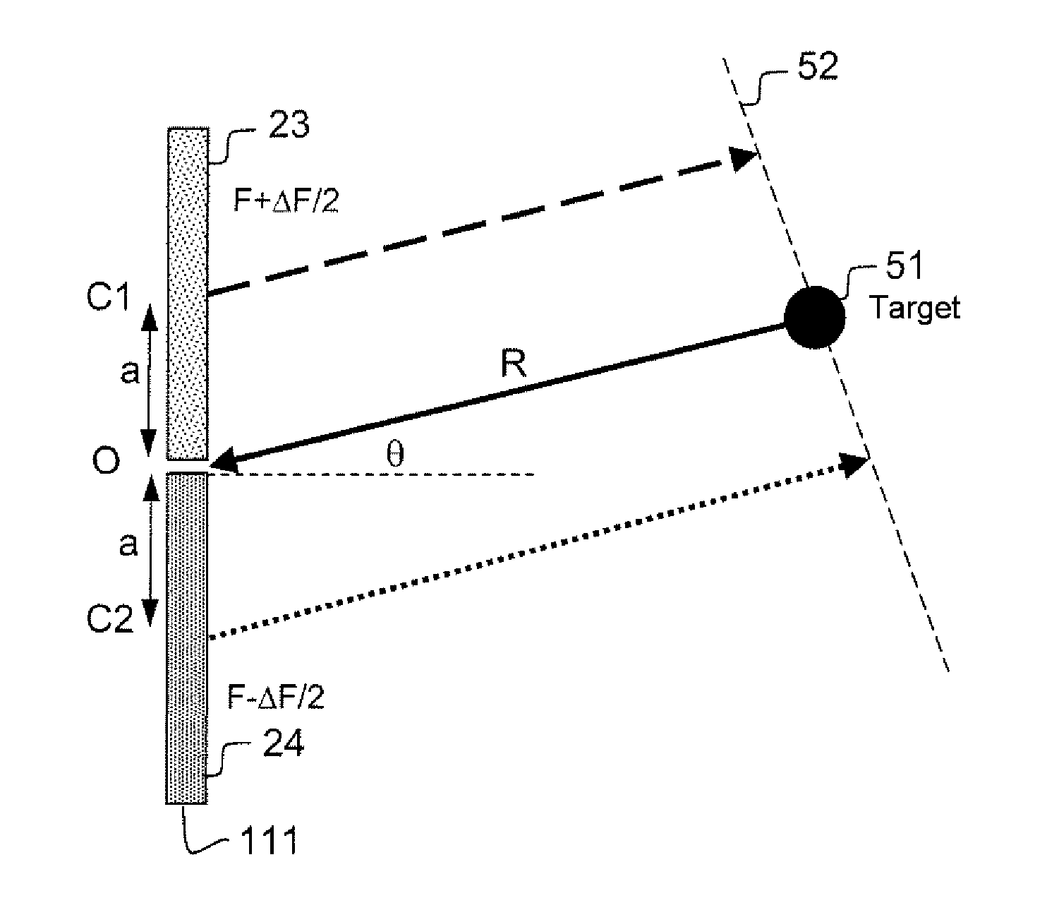
[0244]This case provides a distance measurement, but the distance is ambiguous (because of the 2π ambiguity in the differential phase) since, during the detection sequence, the angle and the RRV were measured unambiguously. Applying equation (14′) leads to the following distance estimate:

[0245]R=c2⁢Δ⁢⁢F⁡[2⁢a⁢⁢sin⁢⁢θλ-Δ⁢⁢ϕ⁢⁢F2⁢π]⁢mod⁢c2⁢Δ⁢⁢F(17)

[0246]For a ΔF value of 50 kHz, the modulo term is equal to 3000 m. Accepting that three ambiguities are contained in the distance domain of the “long range” waveform, the state vector is set as follows:

[0247](R⁢⁢R⁢⁢VUnambiguous⁢⁢distance=RS⁢⁢N⁢⁢RAnglesAmbiguous⁢⁢distance⁢⁢1=R+c2⁢Δ⁢⁢F0Quality⁢⁢index=1Ambiguous⁢⁢distance⁢⁢2=R+2⁢c2⁢Δ⁢⁢F0Event⁢⁢counter=1Ambiguous⁢⁢distance⁢⁢3=R+3⁢c2⁢Δ⁢⁢F0) 

[0248]The SNR of the three non-detection cycles is set to zero. In practice, four estimators are opened with the four distance assumptions. It is possible, within a safety principle, to transmit a prewarning to the navigation system relating to the track corres...

case 3

[0249]This case provides an unambiguous distance measurement. It is sufficient for there to be two valid detections in four and to have a judiciously chosen set of ΔF values. The possible principles for resolving the distance ambiguity are discussed in the next paragraph.

[0250]An example of how the distance ambiguity is resolved, in a preferential solution in tracking initialization phase, is given below for a simplified case, ignoring the ambiguity in the differential phase. Given the measurement of the target angle θ coming from the detection sequence, equation (14′) shows that each differential phase measurement allows an estimate of the distance modulo the distance ambiguity.

[0251]If the situation is limited to the first ambiguity, the following equations may be written, for example in the case of two valid differential phase measurements:

[0252]Ra=c2⁢Δ⁢⁢Fa⁡[a⁢⁢sin⁢⁢θλ-Δϕ⁢⁢Fa2⁢π]Rb=c2⁢Δ⁢⁢Fb⁡[a⁢⁢sin⁢⁢θλ-Δϕ⁢⁢Fb2⁢π]

[0253]With two measurements, it is possible to calculate, for exampl...


PUM


Abstract

An airborne radar device having a given angular coverage in elevation and in azimuth includes a transmit system, a receive system and processing means for carrying out target detection and location measurements. The transmit system includes: a transmit antenna made up of at least a first linear array of radiating elements focusing a transmit beam, said arrays being approximately parallel to one another; at least one waveform generator; means for amplifying the transmit signals produced by the waveform generator or generators; and means for controlling the transmit signals produced by the waveform generator or generators, said control means feeding each radiating element with a transmit signal. The radiating elements being controlled for simultaneously carrying out electronic scanning of the transmit beam in elevation and for colored transmission in elevation.

Description

CROSS-REFERENCE TO RELATED APPLICATION[0001]This application claims priority to foreign French patent application No. FR 09 04394, filed on Sep. 15, 2009, the disclosure of which is incorporated by reference in its entirety.FIELD OF THE INVENTION[0002]The present invention relates to an airborne radar having a wide angular coverage, notably for the sense-and-avoid function with which for example drones are equipped.BACKGROUND OF THE INVENTION[0003]The technical problem relates to providing aircraft, particularly drones, with a radar function for the non-cooperative detection of aerial obstacles. This function is essential for allowing autopiloted aircraft to fly in a non-segregated aerial region. It forms part of what is called the “sense-and-avoid” function.[0004]Such a radar must have a very wide field of observation (typically±110° in azimuth and ±15° in elevation) and must be capable of scanning space in a very short time, of the order of magnitude of one second, owing to the ti...

Claims


Application Information

Patent Timeline
Patent Type & Authority Patents(United States)
IPC IPC(8): G01S13/42G01S13/933
CPCG01S13/426G01S13/72G01S13/9303G01S2013/0254G01S13/933
Inventor KEMKEMIAN, STEPAHNECORNIC, PASCALLE BIHAN, PATRICKNOUVEL-FIANI, MYRIAM
Owner THALES SA
Why Eureka
Try Eureka