Systems and methods for calibration based indoor geolocation

a technology of indoor geolocation and system and method, applied in the direction of location information based service, wireless commuication service, direction finder using radio waves, etc., can solve the problems of indoor environment toa techniques, high accuracy of distance estimation process, and failure of indoor environment traditional location techniques such as gps, so as to minimize calibration costs, facilitate on-going, and improve the accuracy of map points in the databas

Active Publication Date: 2016-09-06
LIGHTHOUSE SIGNAL SYST
View PDF7 Cites 237 Cited by
  • Summary
  • Abstract
  • Description
  • Claims
  • Application Information

AI Technical Summary

Benefits of technology

[0008]Various embodiments of the present invention feature systems / methods that facilitate on going, accurate calibration of a fingerprint database using unskilled persons, so as to minimize the calibration cost. Alternatively, or in addition, these systems / methods can improve the accuracy of map points in the database. This is achieved, in part, by providing a mechanism to verify the accuracy of at least some of the data received from a calibrator's device. The verification can be performed, at least in part, by comparing a piece of data received from a calibrator (also called user) with corresponding expected data stored in a database. Alternatively, or in addition, the accuracy of RF data received from a user can be determined, at least in part, by correlating those and / or other user-supplied data with sensor data received from one or more sensors installed in the user's device. These correlations can also be used in computing the location of a different user who is not the calibrator. Based on the determined accuracy, a weight is assigned to the RF data received from the user's device and used to synthesize a fingerprint, such that the readings determined to contain an error are weighted less than the readings determined to be substantially error free. Thus, a high quality fingerprint database can be obtained without having to rely on trained personnel for calibration.
[0009]Accordingly, in one aspect, a method for determining a location of a user within an indoor environment includes receiving radio frequency (RF) signal data from each RF source from several RF sources. For each RF source, the yield thereof is computed based on the received data. The method also includes selecting a subset of fingerprints from a database of fingerprints, based on, at least in part, the yield associated with each one of the several RF sources. In addition, the method includes receiving tracking data from a sensor, such as an inertial navigation system (INS), and determining a location of a user based on, at least in part: (i) the RF signal data received from each of the RF sources in the subset, and (ii) the received tracking data. Thus, the accuracy of location determination can be improved, e.g., by corroborating the estimates obtained from an RF fingerprint database with the estimates of user movement obtained from, e.g., the INS data.
[0017]Thus, in computing a fingerprint for a new map point to be added to the map-point grid, the RF data observed from a certain RF source, and to be used in computing the fingerprint, may be refined based on how RF data from that source was recorded at some other map points that may be near the new map point. This can increase the accuracy of the fingerprint associated with the new map point. Updating the received RF signal data may include computing an average of a parameter of the received RF signal data. The average can be a weighted average, and the parameter may be RF signal power, yield data, or a combination thereof. Before adding the new map point to the grid, a location of a user based on, at least in part, a location confirmation signal may be obtained at the new map point. The location confirmation signal can be provided, e.g., in response to a user indicating his or her presence at a certain location, e.g., by tapping on a corresponding location in a map displayed on the user's device. The method may include determining if the computed location is substantially same as the received location. The new map point may be added if the comparison is successful.
[0022]In some embodiments, the grid includes a route corresponding to a set of map points, and receiving the RF signal data includes receiving several calibration scans corresponding to the route. Receiving each scan includes receiving sensor data associated with each map point in the set of map points corresponding to the route. To update the map-point grid, for each calibration scan, a value of a route parameter is determined, based on, at least in part, the sensor data corresponding to the scan. A weight is assigned to each calibration scan, based on, at least in part, a comparison of the determined value of the route parameter and a statistical value associated with the route parameter. Thus, for a single route, several scans may be obtained from one or more users. Scans determined to be unreliable based on a statistical analysis can be rejected or underweighted, so as to improve the quality of the fingerprint database.
[0025]In some embodiments, the systematic analysis further includes selecting a set of segments, such that each segment in the set includes a map point that is within a specified distance (e.g., a few feet, tens of feet, etc.) from a map point corresponding to the candidate segment. Thus, the segments in the set are likely to be close to the candidate segment. A fitness measure based on a comparison of a fingerprint associated with the map point corresponding to the candidate segment and map points corresponding to the segments in the selected set may be computed. As map points of nearby segments are likely to have similar map points, the fitness measure can indicate accuracy of the fingerprint associated with the candidate segment. Therefore, the method may include further adjusting the weight associated with the candidate segment based on, at least in part, the fitness measure.

Problems solved by technology

Traditional location techniques such as GPS are shown to be unsuccessful in indoor environments because physical barriers degrade GPS signals.
In indoor environments, the GPS signals are blocked by different objects, so they are attenuated to such an extent that they are either not detectable by the receiver or the distance estimation process yields highly inaccurate distance.
TOA techniques in indoor environments also suffer from the same problem.
In indoor environments, the signals between stations are usually blocked by interior objects in the indoor environment, so the line-of-sight component of the signal is not detectable.
The NLOS condition is shown to be the most problematic cause of inaccurate indoor location for TOA techniques.
However, it is also shown that signal power changes rapidly over time.
The stations in indoor environments suffer even more from this change as they face lots of obstacles within indoor environments.
Therefore, such RSS systems also have found limited use for indoor positioning.
A typical problem with the fingerprint database is that the database can become out-of-date frequently.
Therefore, these RF sources can change over time, causing the fingerprint database to become out of date.
Such a calibration can be prohibitively expensive.
Calibrations can be performed in a cost-effective manner using unskilled persons, but these calibrations can be unreliable due to human errors in calibration.

Method used


Image

  • Systems and methods for calibration based indoor geolocation
  • Systems and methods for calibration based indoor geolocation
  • Systems and methods for calibration based indoor geolocation

Examples


Embodiment Construction

[0046]To provide an overall understanding of the invention, certain illustrative embodiments will now be described, including systems and methods for indoor geolocation and calibration of a fingerprint database / map-point grid. However, it will be understood by one of ordinary skill in the art that the systems and methods described herein may be adapted and modified as appropriate for the application being addressed and that the systems and methods herein may be employed in other suitable applications, and that such other additions and modification will not depart from the scope thereof.

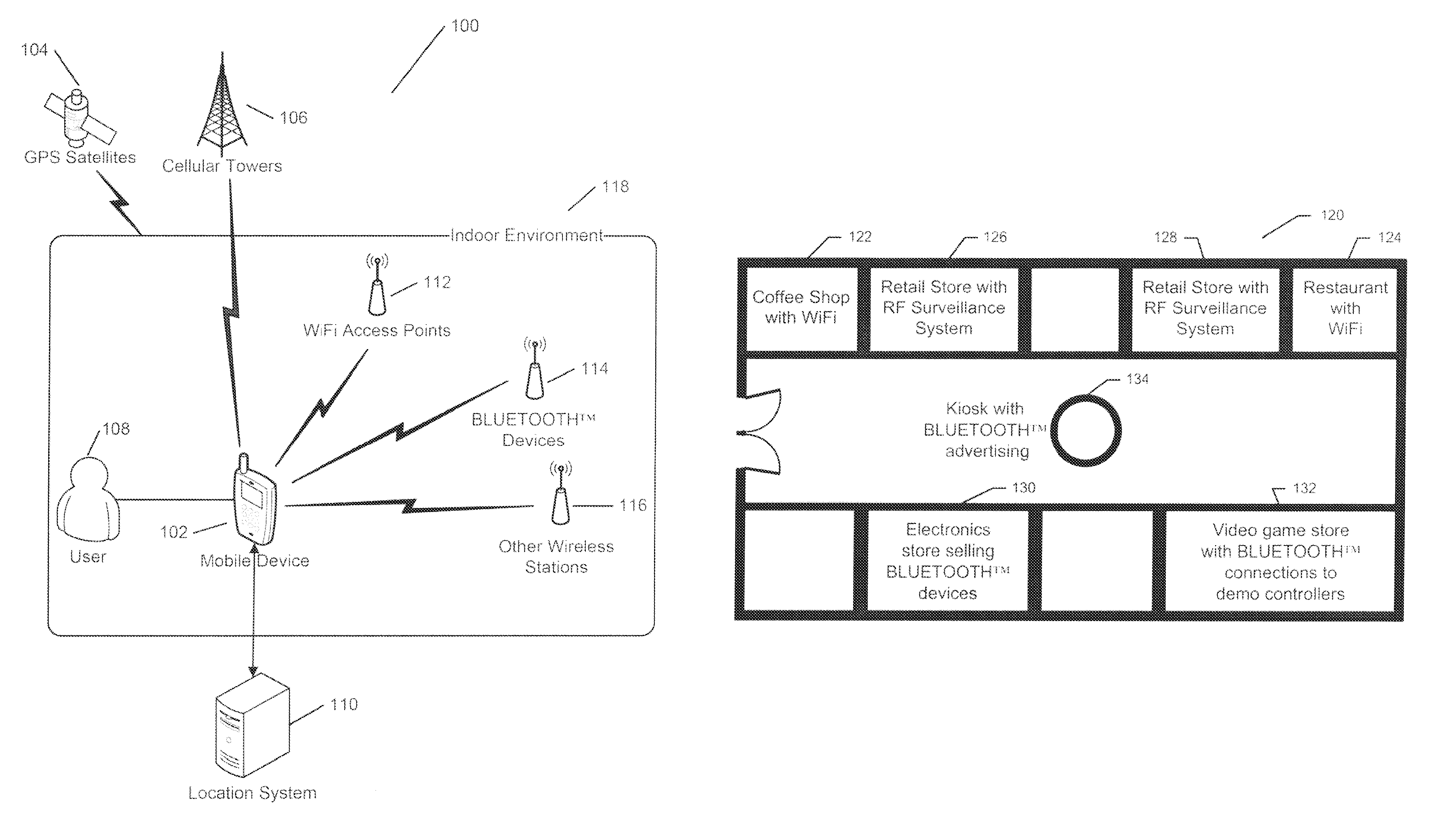
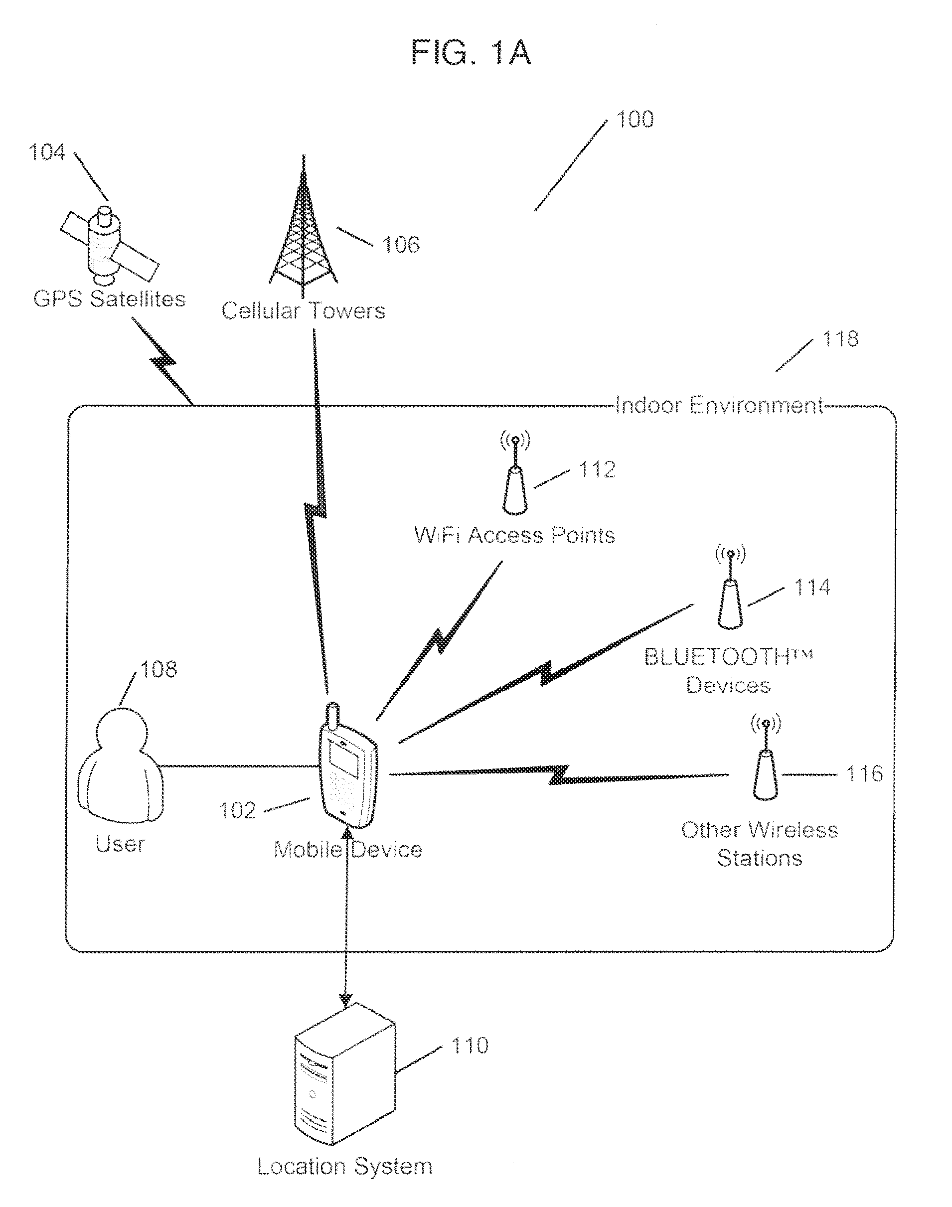
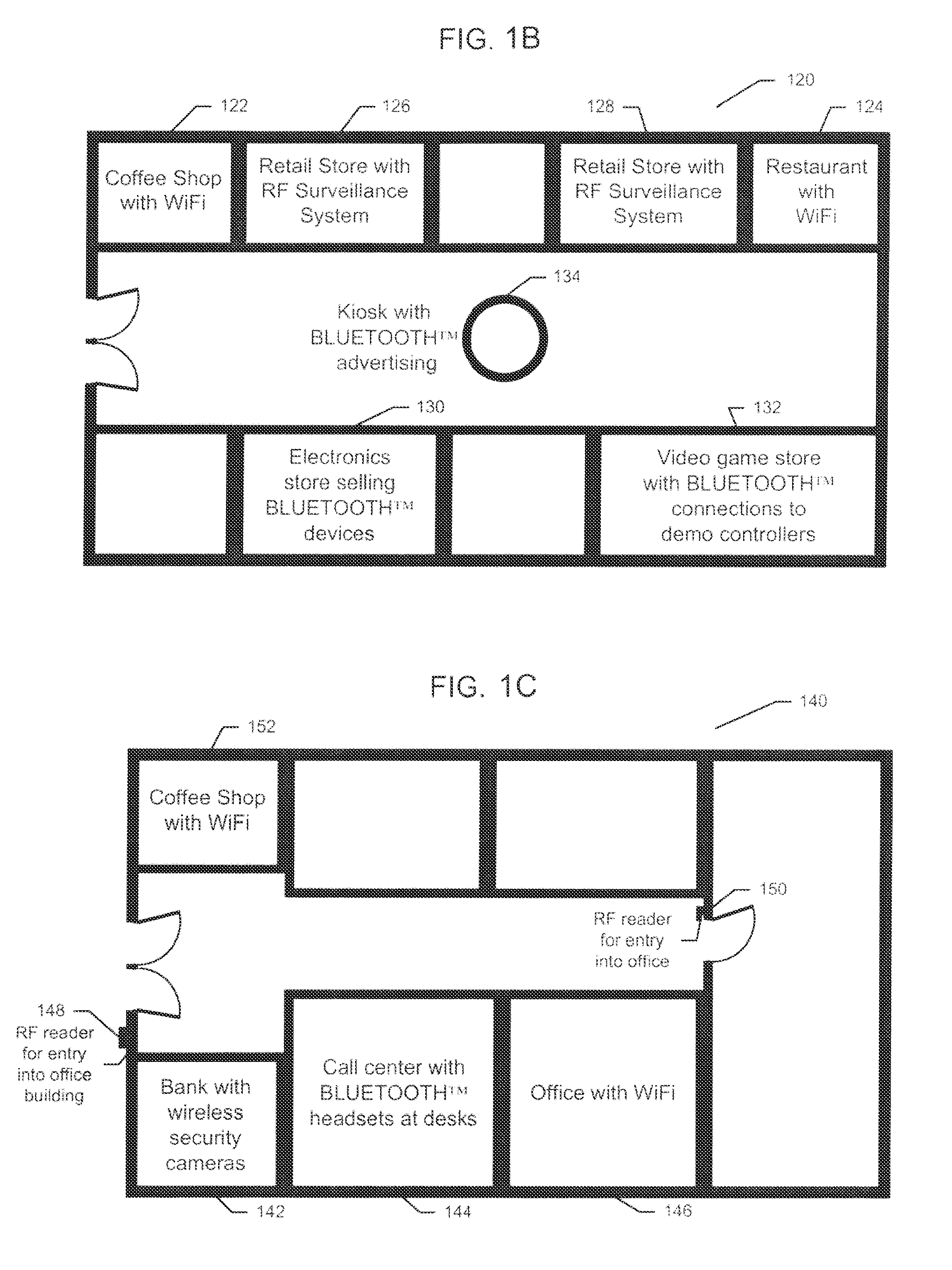
[0047]FIG. 1A is a schematic diagram of a system 100 for indoor geolocation, i.e. determining one's location in an indoor environment, according to an illustrative embodiment of the invention. FIG. 1B and FIG. 1C are examples of maps of indoor environments in which the system 100 may be used. The indoor geolocation system 100 includes a mobile device 102 and a location system 110. The user 108 uses th...


PUM


Abstract

In a system facilitating the calibration of a map-point grid for an indoor location determination, the grid includes several map points, each having a radio frequency (RF) data fingerprint being associated therewith. At least one of: (i) RF signal data from several RF sources, (ii) a user specified location indication, and (ii) tracking data from a sensor, the tracking data indicating a user's movement relative to a base map point, are received. The map-point grid is updated based on, at least in part, at least one of (i) adjusted RF data, the received RF data being adjusted using systematic analysis thereof, (ii) the tracking data, and (iii) the location indication. A user's location may be determined based on the fingerprints associated with the map-point grid, and sensor data.

Description

CROSS-REFERENCE TO RELATED APPLICATIONS[0001]This application claims the benefit of and priority to U.S. Provisional Patent Application Ser. No. 61 / 666,520, filed Jun. 29, 2012, the entire contents of which are incorporated herein by reference.BACKGROUND OF THE INVENTION[0002]Recently, the problem of determining the location of a person or object in indoor environments has gained tremendous attention. The applications of such systems include locating public safety officers in indoor environments, locating valuable objects or instruments in hospitals, and monitoring youngsters and elderly people in indoor environments. The main two approaches to positioning are time-of-arrival (TOA) techniques and received-signal-strength (RSS) techniques. In systems using TOA techniques, a mobile station broadcasts an impulse (a very wideband signal), and all the fixed stations, with known coordinates, respond to it. From that response, the mobile station or a central server can determine the mobile...

Claims


Application Information

Patent Timeline
Patent Type & Authority Patents(United States)
IPC IPC(8): G01S3/02H04W4/02H04W4/04H04W4/029H04W4/33
CPCH04W4/025H04W4/043H04W4/33H04W4/029
Inventor PARVIZI, PARVIZHEIDARI, MOHAMMAD
Owner LIGHTHOUSE SIGNAL SYST
Why Eureka
Try Eureka