Aircraft navigation system and method of navigating an aircraft

a technology of aircraft navigation and navigation system, applied in vehicle position/course/altitude control, process and machine control, instruments, etc., can solve problems such as affecting civil or military aviation, affecting the safety of aircraft navigation, so as to improve operation security and improve operation security.

Active Publication Date: 2017-09-05
AIRBUS DEFENCE & SPACE
View PDF8 Cites 4 Cited by
  • Summary
  • Abstract
  • Description
  • Claims
  • Application Information

AI Technical Summary

Benefits of technology

[0012]There may be a need for an aircraft navigation system providing improved operation security, particularly providing improved security in case of C / A GPS jamming or spoofing Similarly, there may be a need for a method of navigating an aircraft with improved operation security.

Problems solved by technology

Unintentional or intentional GPS-signal-in-space degradation, sometimes referred to as “jamming,” and intentional GPS-signal-in-space alteration by third parties, sometimes referred to as “spoofing,” may pose a great threat to civil or military aviation since the aircraft position as measured by on-board civil or military GPS-receivers may be impaired, in the case of jamming, or deliberately altered, in the case of spoofing, by third parties on-ground and in-air.
This may lead to degradation or loss of the aircraft GPS position and, in worst-case scenarios, even to deliberate aircraft hijacking.
Furthermore, communication channels may be jammed or spoofed.
This may be especially problematic for remotely piloted aircraft since the pilot can no longer actively control the RPA.
Communication channels can be protected against spoofing with encryption, but it is very hard to protect them against jamming.

Method used


Image

  • Aircraft navigation system and method of navigating an aircraft
  • Aircraft navigation system and method of navigating an aircraft

Examples


Embodiment Construction

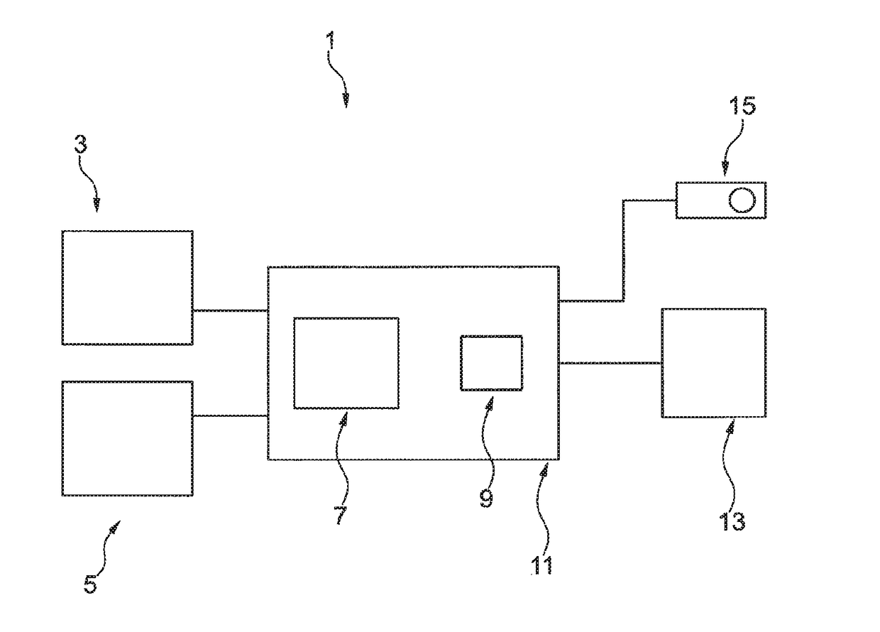
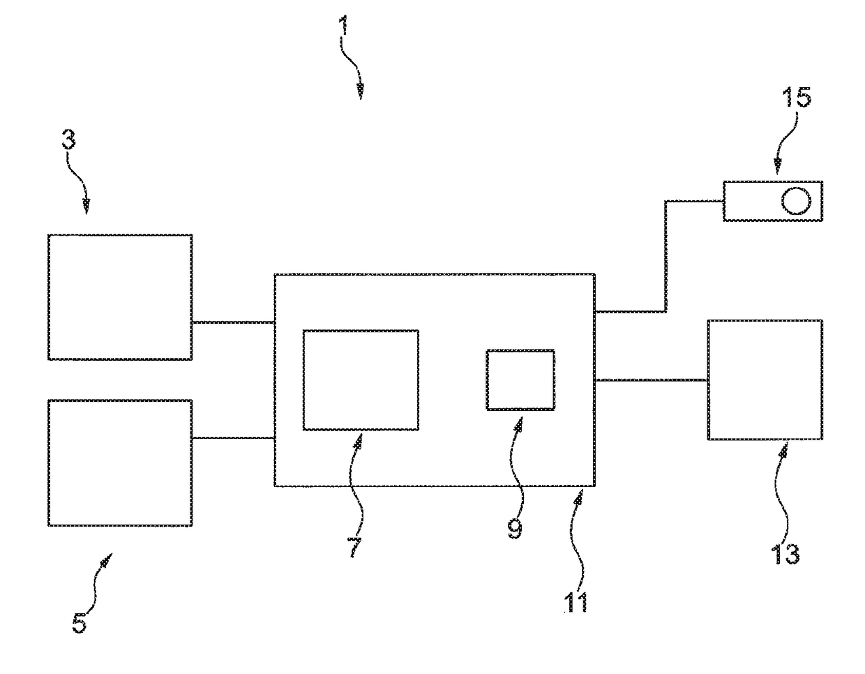
[0028]The FIGURE shows an aircraft navigation system 1 according to an embodiment of the present invention. The aircraft navigation system 1 may be implemented, for example, in state aircraft such as military aircraft, police aircraft, emergency aircraft, etc.

[0029]The aircraft navigation system 1 comprises a civil-certified GPS-receiver 3 as well as a military-type GPS-receiver 5.

[0030]The civil-certified GPS-receiver 3 is adapted and configured to determine a first position information based on C / A-GPS-signals. Such first position information may, for example, indicate a current position of the aircraft with a precision of approximately 5-10 m accuracy. Such civil-certified GPS-receiver 3 may be certified for civil aviation, for example, by a governmental civil aviation agency.

[0031]The military-type GPS-receiver 5 is adapted and configured to determine a second position information based on P(Y)-GPS-signals. Such military-type GPS-receiver is generally not certified for civil avi...


PUM


Abstract

An aircraft navigation system and navigation method. The system comprises a civil-certified GPS-receiver for determining first position information based on C / A-GPS-signals, and a military-type GPS-receiver for determining a second position information based on P(Y)-GPS-signals. A monitoring unit detects a first abnormal condition during jamming conditions within the C / A-GPS-signals. The unit compares the first position information with the second position information and detects a second abnormal condition when a difference between these position information is larger than a threshold value for more than a threshold duration. Upon detecting an abnormal condition, an alert procedure is initiated. In remotely piloted aircraft, Command & Control link-loss is also monitored and during link-loss, a transponder code automatically indicates communication failure. When in such situation an abnormal condition is additionally detected, a transponder code indicates airborne emergency and, subsequently, the aircraft navigation system is switched to navigating based on position information from the military-type GPS-receiver.

Description

CROSS-REFERENCES TO RELATED APPLICATIONS[0001]This application claims the benefit of the European patent application No. 13005294.7 filed on Nov. 11, 2013, the entire disclosures of which are incorporated herein by way of reference.FIELD OF THE INVENTION[0002]The present invention relates to an aircraft navigation system and to a method of navigating an aircraft.BACKGROUND OF THE INVENTION[0003]Aircraft have to be navigated during flight. Manned aircraft are generally navigated by a pilot in command on board of the aircraft. Unmanned aircraft such as remotely piloted aircraft (RPA) are generally navigated automatically using on-board piloting computers. In some systems, high-level commands may be submitted by an off-board pilot being located, for example, in a ground control center and remotely piloting the aircraft using communication channels. Sometimes, RPAs are also referred to as unmanned aerial vehicles (UAV) or unmanned aerial systems (UAS).[0004]In order to be able to follow...

Claims


Application Information

Patent Timeline
Patent Type & Authority Patents(United States)
IPC IPC(8): G01S1/00G01S19/18G08G5/00G05D1/00G01S19/21G01S19/32G06F19/00
CPCG01S19/32G01S19/18G01S19/21G05D1/0022G05D1/0077G08G5/0004
Inventor BIANCHI, CRISTIANOLOHMILLER, WINFRIED
Owner AIRBUS DEFENCE & SPACE
Why Eureka
Try Eureka