Remote sensing and quantizing reconnaissance method of snowslide
A remote sensing, high-resolution technology, applied in measurement devices, geophysical measurements, instruments, etc., can solve problems such as inability to meet engineering construction, dependence, etc., to achieve automatic extraction, high accuracy, and avoid life-threatening effects.
- Summary
- Abstract
- Description
- Claims
- Application Information
AI Technical Summary
Problems solved by technology
Method used
Image
Examples
Embodiment Construction
[0027] Below in conjunction with accompanying drawing, the present invention is described in further detail:
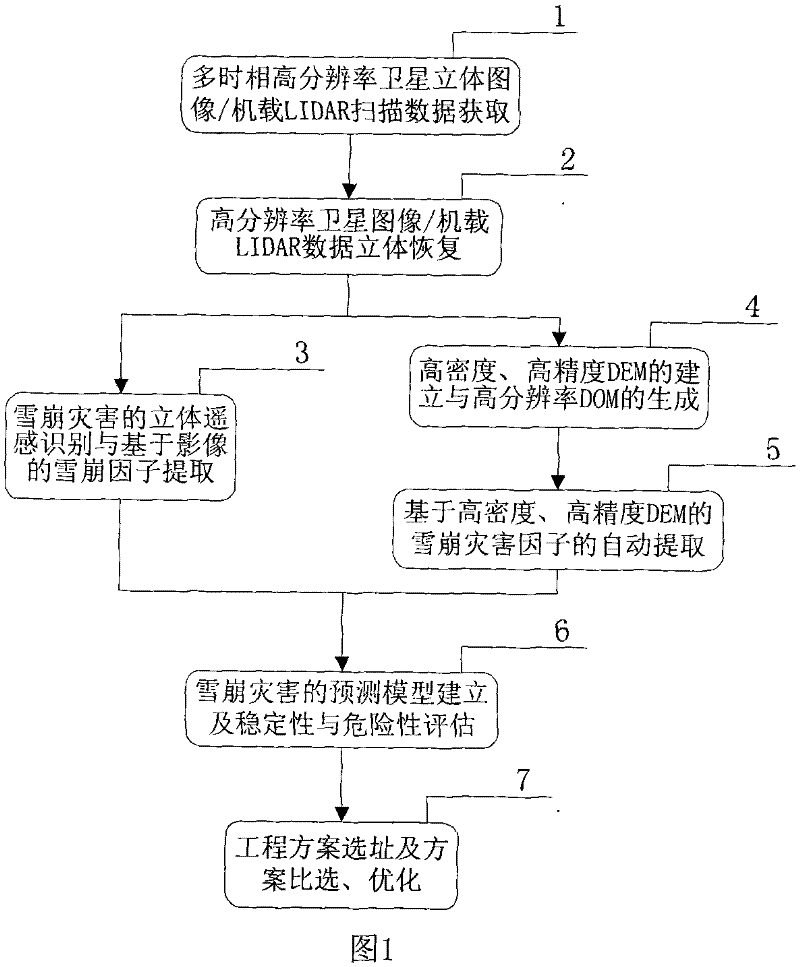
[0028] An avalanche remote sensing quantitative survey method, such as figure 1 As shown, it contains the following steps:
[0029] The first step, multi-temporal high-resolution satellite stereo image / airborne LIDAR scanning data acquisition1
[0030] The survey area should select at least two different periods (two periods with less snow cover and more periods), and the resolution of satellite imaging is less than 1m high-resolution satellite stereoscopic images, such as IKONOS satellite images with a resolution of 1m, or The 0.47m WorldView satellite image can also be the image obtained by airborne LIDAR scanning with CCD camera in different periods.
[0031] High resolution satellite stereo imagery should have rational function sensor model (RPC) parameters. Airborne LIDAR data should have attitude positioning parameters such as GPS and IMU (inertial measuremen...
PUM
 Abstract
Description
Claims
Application Information
 - R&D
- Intellectual Property
- Life Sciences
- Materials
- Tech Scout
- Unparalleled Data Quality
- Higher Quality Content
- 60% Fewer Hallucinations
Browse by: Latest US Patents, China's latest patents, Technical Efficacy Thesaurus, Application Domain, Technology Topic, Popular Technical Reports.
© 2025 PatSnap. All rights reserved.Legal|Privacy policy|Modern Slavery Act Transparency Statement|Sitemap|About US| Contact US: help@patsnap.com


