GPS fast relocation method

A relocation and fast technology, applied in the field of GPS, can solve the problems of satellite loss of lock and inability to locate the process, achieve fast relocation, reduce the time of judging the lock, and reduce the time-consuming effect of searching

Inactive Publication Date: 2010-03-17
ANYKA (GUANGZHOU) MICROELECTRONICS TECH CO LTD
View PDF0 Cites 11 Cited by
  • Summary
  • Abstract
  • Description
  • Claims
  • Application Information

AI Technical Summary

Problems solved by technology

[0011] During the positioning process, it is unavoidable to be affected by the surrounding tall buildings, resulting in the temporary loss of lock of the satellites participa...

Method used


Image

  • GPS fast relocation method
  • GPS fast relocation method
  • GPS fast relocation method

Examples


Embodiment Construction

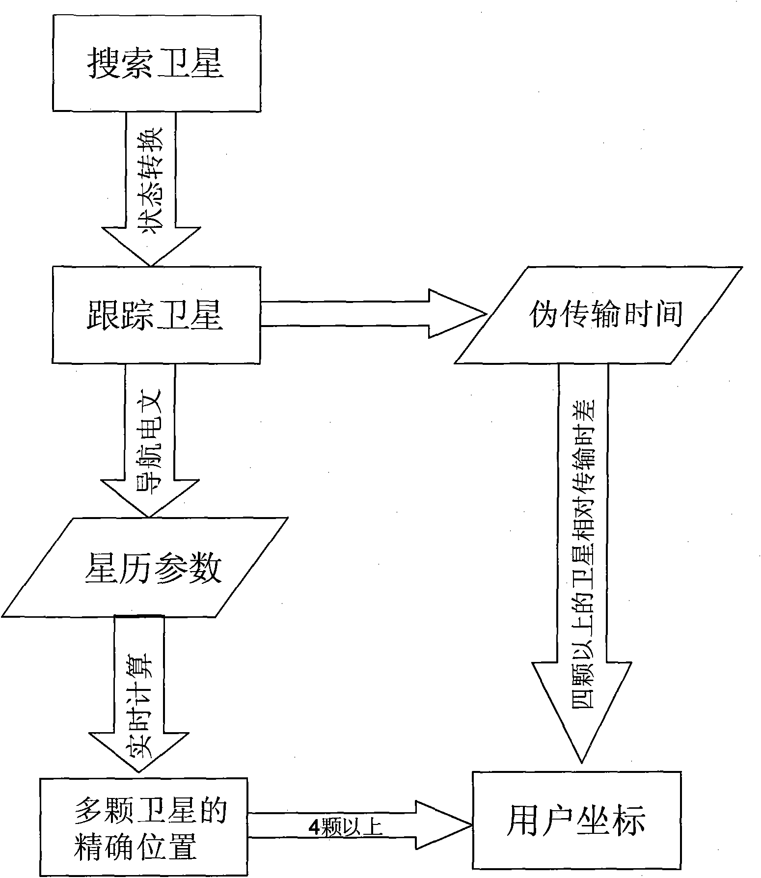
[0034] The present invention is based on the GPS fast relocation method. Since the frequency Doppler and phase of the satellite can be obtained by the tracking loop, if a certain satellite loses lock due to temporary occlusion, it can be relocated through the steps of the following specific embodiments operate:

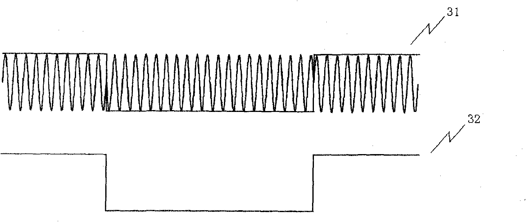
[0035] see Image 6 As shown in the flow chart of the GPS fast relocation method of the present invention, during the tracking process, the GPS software system will constantly judge whether the satellite has lost lock. The basis for judging is: in the normal ideal tracking state, the jump point interval of the C / A code is 20 or a multiple of 20. The pseudo-random code CA is used to spread the spectrum before GPS signal modulation. Each bit of navigation information takes 20ms, and each complete C / A code takes 1ms. In this way, each bit of navigation data is spread with 20 cycles of C / A codes. ginseng image 3 (31 in the figure is the input signal of the C / A code, ...


PUM


Abstract

The invention relates to a GPS fast relocation method, comprising the following steps: a GPS software system judges weather the satellite is unlocked, an elevation angle relative to the current satellite is calculated according to long-term ephemeris data, Doppler with high precision and C/A code phase are read from a tracking ring, thin search is carried out to the Doppler and the C/A code phase,yardage before losing lock is adjusted, and then relocation is carried out according to cycle number, cycle time, C/A yardage and C/A code phase. The searching range is shortened by utilizing the Doppler and phase value before losing lock, searching time is reduced by utilizing multi-channel parallel search, locking judgment time is reduced by utilizing small probability of continuous no trippingof the C/A code, by utilizing that the change relative to the pseudo range within a short time is little and using time synchronization principle of all satellites, pseudo range of the satellite which is justly locked and the satellite time information can be fast synthesized, thereby compressing the needed relocation time in an omnibearing way.

Description

technical field [0001] The invention belongs to the technical field of GPS (satellite positioning system), in particular to a GPS fast repositioning method. Background technique [0002] Such as figure 1 , the two core parts of the GPS macrostructure are: ephemeris data and transmission time. Satellite ephemeris data includes satellite week number, week time, satellite health status, satellite orbit parameters, ionospheric correction parameters and satellite time correction parameters. According to satellite ephemeris, the coordinates of satellites can be calculated. [0003] GPS ephemeris data can be divided into two categories: short-term data: the first to third subframes of ephemeris data, repeated every 30s, and updated about 12 hours under normal circumstances. Long-term data: Frames 4-5 of the ephemeris data can be completely transmitted after 25 frames, which is called "super frame". Repeated every 750s, normally updated once a week. Since it is used to calculate...

Claims


Application Information

Patent Timeline
IPC IPC(8): G01S1/02G01S5/02
Inventor 杨海珠胡胜发
Owner ANYKA (GUANGZHOU) MICROELECTRONICS TECH CO LTD
Why Eureka
Try Eureka