Optical system for stereo mapping with low base-height ratio

A technology for stereo mapping and optical systems, applied in the field of optical systems, can solve the problems of difficulty in achieving stereo mapping on the same track or different tracks, complicated automatic processing by computers, and low correlation of image matching, so as to improve the stability, the accuracy of surveying and mapping, and the weight. Light, rigid and structurally stable results

Active Publication Date: 2010-06-02
BEIJING RES INST OF SPATIAL MECHANICAL & ELECTRICAL TECH
View PDF0 Cites 18 Cited by
  • Summary
  • Abstract
  • Description
  • Claims
  • Application Information

AI Technical Summary

Problems solved by technology

Using such commercial high-resolution transmission remote sensing satellites with surveying and mapping functions to complete precise surveying and mapping of global hot spots and local target areas, this solution is currently limited by bottlenecks such as high-precision attitude control technology and agile satellite stereo imaging technology. This surveying and mapping system is more suitable for large base-height ratio surveying and mapping (B / H is about 1), and it is difficult to realize same-orbit or different-track three-dimensional surveying and mapping with a small base-height ratio
The problems caused by the large base-to-height ratio mainly include: excessive image distortion, greater influence by shadows and occlusions, large observation differences between stereo pairs, low synchronization, small image matching correlation, and complex automatic processing by the computer , and the large base height ratio is not suitable for 3D measurement of steep features (including cities)

Method used


Image

  • Optical system for stereo mapping with low base-height ratio
  • Optical system for stereo mapping with low base-height ratio
  • Optical system for stereo mapping with low base-height ratio

Examples


Embodiment Construction

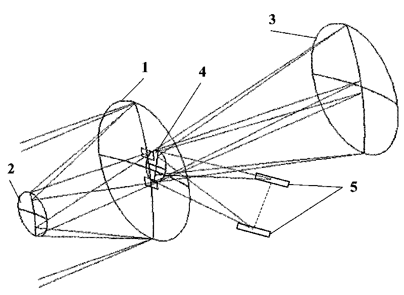
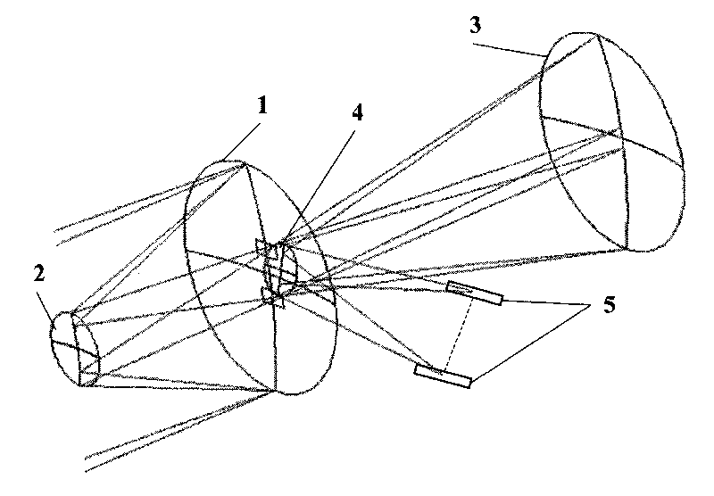
[0020] Such as figure 1 As shown, the optical system of the present invention includes a common primary mirror 1 , a common secondary mirror 2 , a common third mirror 3 , a common plane turning mirror 4 and a receiving image plane 5 . The shared primary mirror 1, the shared secondary mirror 2 and the shared third mirror 3 are coaxial and used as the main optical axis of the optical system. The shared primary mirror 1 is provided with two centrally symmetrical light holes, and the angle between the two different fields of view is 1 The light from the field of view of °~6° is symmetrically incident on the common primary mirror 1 from the left side with the main optical axis as the center, and after being reflected by the common primary mirror 1 and the common secondary mirror 2, it passes through two light holes to reach the common third mirror 3. The common plane turning mirror 4 is located on the right side of the common main mirror 1 and between the two light holes. It is us...


PUM


Abstract

The invention provides an optical system for stereo mapping with a low base-height ratio, which is used in a bias-field, adopts a coaxial tri-mirror system in which a primary mirror, a secondary mirror, a tertiary mirror and a reflecting plane mirror are completely shared, and is formed by combining two independent optical imaging paths. Two groups of incident light rays each of which has an included angle of 1 to 6 degrees sequentially reach the primary mirror, the secondary mirror and the tertiary mirror; and finally, the incident light rays are respectively reflected to two independent receiving image planes for imaging by the reflecting plane mirror. By using the bifocal surface as well as the primary mirror, the secondary mirror, the tertiary mirror and the reflecting plane mirror which are simultaneously shared, the invention is capable of simultaneously imaging in front and rear fields of view, therefore, the stereoscopic mapping with a low base-height ratio and high precision can be achieved by the reflection-type optical system capable of imaging on a single-camera and double-channel basis. The optical system has the advantages of high optical-mechanical structural integrity, small size, light weight, convenient real-time on-orbit detection and high stability of inner orientation elements. Therefore, the optical system is particularly applicable to single-track push-broom stereo imaging and mapping by a satellite camera in surveying and mapping with a low base-height ratio.

Description

technical field [0001] The invention belongs to the technical field of aerospace optical remote sensors, and relates to an optical system suitable for space-to-ground high-precision three-dimensional surveying and mapping with a small base height ratio (B / H). Background technique [0002] Due to the rapid development of aerospace optical remote sensor technology, the requirements for the application level of remote sensor systems continue to increase. [0003] Surveying and mapping satellites use satellites, spacecraft or space stations as platforms to carry imaging sensors that meet the requirements of stereo photography to take pictures of the earth's surface, obtain image information, and process photogrammetry to accurately measure the topography of the earth's surface, the shape and size of objects (targets) and spatial location to generate various surveying and mapping support products required to support the battlefield. [0004] The base height ratio is one of the i...

Claims


Application Information

Patent Timeline
Patent Type & Authority Applications(China)
IPC IPC(8): G01C11/02
Inventor 傅丹膺杨秉新方勇李博曾勇强李瀛搏王建永姚罡
Owner BEIJING RES INST OF SPATIAL MECHANICAL & ELECTRICAL TECH
Why Eureka
Try Eureka