Fractal multi-resolution simplified method used for large-scale terrain rendering

A large-scale terrain and multi-resolution technology, applied in the field of visual simulation, can solve problems such as large-scale complex terrain takes a long time, and it is difficult to achieve real-time display.

Inactive Publication Date: 2011-05-25
HARBIN ENG UNIV
View PDF3 Cites 35 Cited by
  • Summary
  • Abstract
  • Description
  • Claims
  • Application Information

AI Technical Summary

Problems solved by technology

[0003] In computer graphics drawing, it takes a long time to generate and display large-scale complex terrain. If you want to make the simulated terrain realistic on a microcomputer with low hardware conditions, it is difficult to do it due to the limitation of existing graphics technology. to real-time display, so it is necessary to further simplify the simulated terrain model

Method used


Image

  • Fractal multi-resolution simplified method used for large-scale terrain rendering
  • Fractal multi-resolution simplified method used for large-scale terrain rendering
  • Fractal multi-resolution simplified method used for large-scale terrain rendering

Examples


example 1

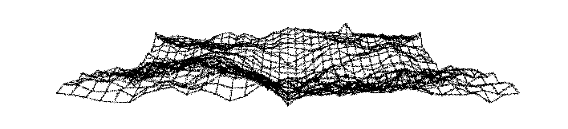
[0033]The rapid generation of large-scale terrain is realized by using the random midpoint displacement method in the fractal representation method. A random perturbation is added to the line segments formed by the vertices of the terrain, and subdivided to produce rich details of the scene. This is done iteratively, bisecting line segments plus random perturbations on every line between vertices in the terrain mesh, until the desired resolution is met. In the process of subdivision, fractal interpolation is performed between two or more points to establish a surface model, and a terrain grid generation method with random midpoint displacement is used to obtain a simulated terrain model with infinite details. The surface features of the terrain are determined by random Offset control. figure 2 is an iterative terrain mesh generated using the random midpoint displacement method.

example 2

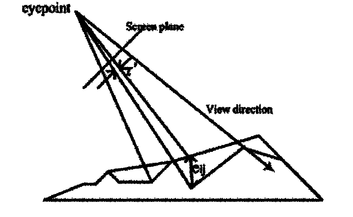
[0035] In simulated terrain, the most detailed, high-resolution models give a realistic feel. However, the more complex the model, the greater the computational overhead. In practical applications, it is often not always required to show the most complete details of the model from beginning to end. The fractal multi-resolution simplification method is applied to the real-time rendering of the scene, and the arbitrary polygon representation in the world coordinate system is redescribed in the view coordinate system. Applies view-dependent clipping, projects the mesh polygons onto the view plane, image 3 Indicates the extent of the terrain covered by the projected viewing frustum. Preliminary clipping is performed based on the frustum range to reduce the number of scene polygons that finally enter the graphics pipeline. Based on the multi-resolution level-of-detail model technology, a group of similar models with different precisions is constructed to represent the scene. Eac...

example 3

[0037] According to the different attention levels of different terrain areas, a multi-level model is established. The level of the multi-level model is determined by factors such as the distance of the viewpoint and the complexity of the terrain itself. The adjacent levels are not necessarily continuous. When forming a 3D model, the adjacent levels Cracks may appear between LOD levels. In order to eliminate the crack phenomenon, the boundary point data of the terrain block is intentionally added in the simplification, and the boundary vertices are added for the low-resolution detail level model of the boundary, and it is forcibly split. Experimental results show that the added data points have little effect on the whole, but it can make the terrain continuous in space. The present invention constructs a view-dependent terrain multi-resolution framework. However, the level of detail of the terrain block is only determined from the perspective of visual correlation, and the inf...


PUM


Abstract

The invention provides a fractal multi-resolution simplified method used for large-scale terrain rendering. The method comprises the following steps: (1) determining a terrain grid rendering region in a scene, firstly carrying out equidistant grid resampling on DEM (digital elevation model) data of coarser grids to form a terrain quadtree node; (2) projecting a view point to an XOZ plane, creating a terrain multi-resolution frame, and setting a plurality of different resolution levels from 1 to n on the terrain by adopting the multi-resolution LOD (level of detail) technology according to the view point; and (3) determining the level of the terrain according to the distances between the view point and different regions of a model, extracting characteristic parameters from an original DEM data set, adopting a DEM-based fractal random midpoint displacement interpolation to generate a continuous real terrain, and realizing reconstruction of a large-scale terrain. The terrain realized by adopting the method in the invention has good space continuity, cracks between different levels in a common multi-resolution model can be avoided, and smooth transition of different resolution models can be realized.

Description

technical field [0001] The invention belongs to the visual simulation technology in the field of virtual simulation, and is a method for real-time rendering of realistic terrain scenes by using virtual reality and computer simulation technology. Background technique [0002] The virtual environment (VE) is an important part of the virtual scene, and the dynamic simulation and display of the terrain environment is an important aspect to reflect the sense of presence in virtual reality. Realistic terrain simulation is different from general object modeling due to its complex surface features. Terrain visualization is one of the keys to virtual simulation. The simulated realistic 3D terrain environment has important applications in the fields of geographic information system (GIS), digital earth, virtual simulation, flight simulation, and 3D games. [0003] In computer graphics drawing, it takes a long time to generate and display large-scale complex terrain. If you want to ma...

Claims


Application Information

Patent Timeline
Patent Type & Authority Applications(China)
IPC IPC(8): G06T17/05
Inventor 赵娜司锡才陈涛贾宗圣
Owner HARBIN ENG UNIV
Why Eureka
Try Eureka