A method of establishing electronic signs in physical geographic space with gis geographic virtual coordinates

A technology of electronic signs and virtual coordinates, applied in the field of geographic information, can solve problems such as lack of signs

Inactive Publication Date: 2011-12-07
国信易雷(天津)电子科技有限公司
View PDF0 Cites 30 Cited by
  • Summary
  • Abstract
  • Description
  • Claims
  • Application Information

AI Technical Summary

Problems solved by technology

However, as a GIS geographic grid node, it also lacks the identification of some entities, and can only be used as virtualized computer information. All
[0004] However, the current grid GIS system is built in the computer network system, and what it presents is only a computer virtual world. The tracking of all management objectives and the acquisition of various substantive business data rely on manual identification and description, which is limited to GIS geographic 2D and 3D images

Method used


Image

  • A method of establishing electronic signs in physical geographic space with gis geographic virtual coordinates
  • A method of establishing electronic signs in physical geographic space with gis geographic virtual coordinates
  • A method of establishing electronic signs in physical geographic space with gis geographic virtual coordinates

Examples


example 1

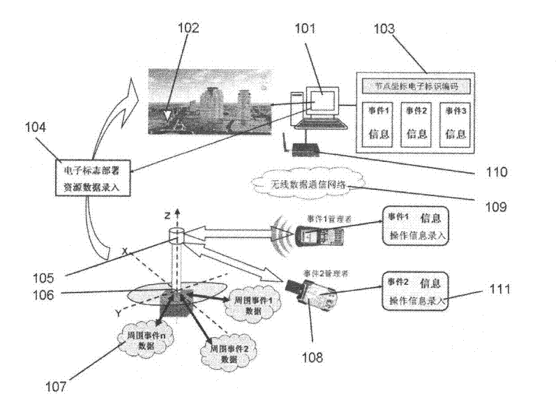
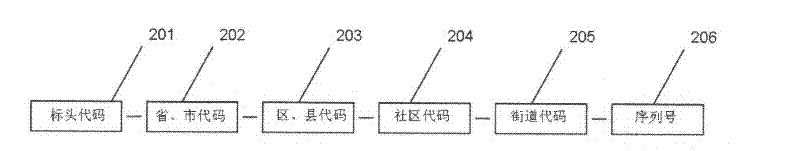
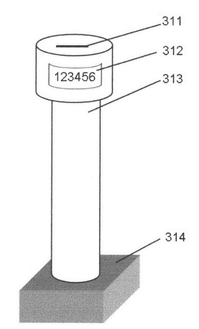
[0065] Example 1, municipal sewer engineering, the specific orientation data mapped between each pipeline and grid node electronic marks and the multi-axis coordinate data of underground pipelines in this area are input into the corresponding database according to the grid node electronic code. When it is necessary to repair the pipeline, as long as the user uses a handheld terminal registered and authorized in the system to read the electronic code of the RFID electronic mark and send it to the GIS system. The system has talked about the analysis of electronic codes, finds out the drawing data of the municipal underground engineering in the area requested by the user from the database, and sends it to the handheld terminal system according to the pre-set authority. The operator can query the specific location and drawings of the underground pipeline in the area on the screen of the terminal, as well as precise information such as the azimuth, distance, and depth from the elect...

example 2

[0066] Example 2, according to the coordinate coding of each building portal of GIS geographic information, install the electronic door plate based on the GIS space electronic sign for each building portal, and write the GIS geographic coordinate code in the electronic label of the electronic door plate. According to the electronic door plate subsystem, the building information, resident information, administrative jurisdiction information, building structure information, water supply, power supply, gas supply and drainage pipeline information, layout information of various equipment used by residents in the building, etc. are written into the database. And this information is heterogeneously reorganized into multiple management systems according to the management systems of each management department. Various management departments use handheld system terminals, as long as they read the electronic house number and link different management systems through the GIS system, they ...

example 3

[0068] Example 3, install electronic tags for the logistics vehicles to be managed, input vehicle information into the database, and preset the network publishing path of the information, such as sending the information to the vehicle management company, traffic management company, etc. when the electronic tag is read department, operations management and consignee. When a logistics vehicle with an electronic tag passes through the first GIS grid node, the reader captures the electronic tag of the vehicle, and the RFID terminal will package and upload the electronic code of the electronic tag and the electronic code of the vehicle electronic tag to the system , the system links the database of the vehicle through analysis, and sends the information to all terminals according to the preset information release route stored in the database. When the vehicle manager receives the information, he can combine the GIS map to see the running position of the vehicle; when the traffic co...


PUM


Abstract

The invention provides a method for establishing an electronic mark in physical geographic space with GIS geographic virtual coordinates, establishes an electronic coding system for geographic space coordinates in the GIS geographic information system, assigns unique electronic codes to the coordinates of each management node, and uses RFID technology to make electronic signs. Mark, and write the electronic code into the RFID chip, and install it in the corresponding physical location. Based on the electronic sign, a functional relationship is established between all targets to be managed in the area and the coordinate electronic sign, and the attribute resource data of the management targets associated with the coordinate electronic sign is established as an IP address according to the coordinate electronic code. The user uses a handheld reading terminal device or an ordinary mobile phone to directly read the electronic identification code of the geographical coordinates of the electronic sign, access the system center through the wireless data communication network, browse the database to obtain the relevant data of the area, so as to realize the management of various management objectives. Effective management and information services that are modernized, intelligentized and automated.

Description

technical field [0001] The invention belongs to the technical field of geographic information, and in particular relates to a method for establishing an electronic sign in physical geographic space with GIS geographic virtual coordinates. Background technique [0002] Geographic Information System (GIS for short) is a comprehensive and integrated information technology integrating computer technology, surveying and mapping science, remote sensing, applied mathematics, information science and earth science. The dissemination and application of geographically related data provides efficient means and systems for acquiring, processing, analyzing, accessing, representing and transferring digitized spatial information between different users, different systems and different locations. At present, the data of GIS come from remote sensing of the earth or satellite images. Since the coordinate system in GIS is determined by two sets of parameters, datum and projection, there are cer...

Claims


Application Information

Patent Timeline
Patent Type & Authority Applications(China)
IPC IPC(8): G06K17/00G06K19/07G06F17/30H04W4/14
Inventor 崔建国崔佳芦嘉望
Owner 国信易雷(天津)电子科技有限公司
Why Eureka
Try Eureka