Geographic information system (GIS) terminal cable fault on-line location method

A technology of terminal cable and ranging method, which is applied in the direction of fault location and fault detection by pulse reflection method, can solve the problems of large positioning error of ranging algorithm, long power failure time, complex traveling wave components, etc., and achieves strong applicability, The effect of a high level of automation

Active Publication Date: 2013-02-27
FOSHAN POWER SUPPLY BUREAU GUANGDONG POWER GRID
View PDF4 Cites 27 Cited by
  • Summary
  • Abstract
  • Description
  • Claims
  • Application Information

AI Technical Summary

Problems solved by technology

On the one hand, the traditional offline ranging method has defects such as long power failure time and the need for special testing instruments; on the other hand, since GIS has no exposed conductor parts, in order to apply voltage for offline fault location, it is necessary to untie the cable terminal. It will affect the advantages of GIS maintenance-free, maintenance-free, safe and reliable, and it will also bring new problems due to disassembly and assembly of cable terminals
[0003] At present, there are mainly two types of online distance measurement for power cables: impedance method and traveling wave method. However, the online distance measurement of GIS terminal cables has the following problems: it is difficult to install a suitable traveling wave signal transmission device in the GIS terminal; there are complex electromagnetic fields in the production site. There are more white noise and pulse noise in the collected traveling wave signal; the strong coup

Method used


Image

  • Geographic information system (GIS) terminal cable fault on-line location method
  • Geographic information system (GIS) terminal cable fault on-line location method
  • Geographic information system (GIS) terminal cable fault on-line location method

Examples


Embodiment Construction

[0019] In order to further illustrate the technical means adopted by the present invention and the achieved effects, the technical solutions of the present invention will be clearly and completely described below in conjunction with the accompanying drawings and preferred embodiments.

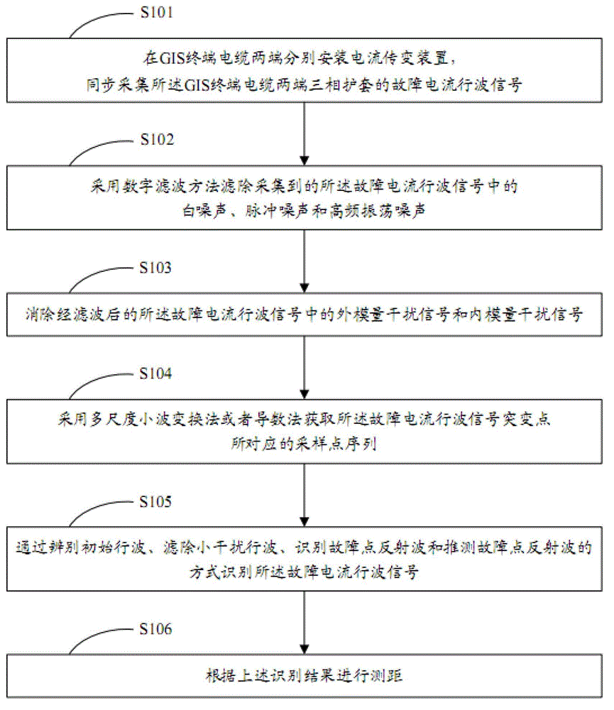
[0020] see figure 1 , is a schematic flow chart of the method for online distance measurement of GIS terminal cable faults according to the present invention. The GIS terminal cable fault online ranging method of the present invention comprises the following steps:

[0021] S101 respectively install current transmission devices at both ends of the GIS terminal cable, and synchronously collect fault current traveling wave signals of the three-phase sheaths at both ends of the GIS terminal cable;

[0022] As one of the embodiments, a core-through current sensor based on the Rogowski coil principle is used to transmit and transform the fault current traveling wave signal of the three-phase cable ...


PUM


Abstract

The invention discloses a geographic information system (GIS) terminal cable fault on-line location method. The GIS terminal cable fault on-line location method comprises the steps of synchronously acquiring fault current travelling wave signals of three-phase sheaths at two ends of a GIS terminal cable, filtering white noise, pulse noise and high-frequency oscillation noise which are acquired in the fault current travelling wave signals, eliminating outer modulus interference signals and inner modulus interference signals in filtered fault current travelling wave signals, obtaining sampling point sequences corresponding to catastrophe points of the fault current travelling wave signals, identifying the fault current travelling wave signals and performing location according to identified results. The GIS terminal cable fault on-line location method has high applicability, reliability, practical applicability and automation level, and the accuracy of fault location can meet the requirement of underground power cable system fault location.

Description

technical field [0001] The invention relates to the technical field of cable fault detection, in particular to a GIS terminal cable fault online ranging method. Background technique [0002] Considering the construction cost and operation and maintenance cost of urban substations, GIS (Gas Insulated Switchgear, Gas Insulated Switchgear) devices are widely used in urban power grids, and the number of cable lines terminated by GIS is also increasing. On the one hand, the traditional offline ranging method has defects such as long power failure time and the need for special testing instruments; on the other hand, since GIS has no exposed conductor parts, in order to apply voltage for offline fault location, it is necessary to untie the cable terminal. It will affect the advantages of GIS maintenance-free, maintenance-free, safe and reliable, and will also bring new problems due to disassembly and assembly of cable terminals. [0003] At present, there are mainly two types of o...

Claims


Application Information

Patent Timeline
IPC IPC(8): G01R31/11
Inventor 张群峰夏成军区伟潮詹清华朱文滔周勇彪李国伟沈勇张鸣张俊
Owner FOSHAN POWER SUPPLY BUREAU GUANGDONG POWER GRID
Why Eureka
Try Eureka