Method for constructing full-space three-dimensional digital earth model

A 3D digital and earth model technology, applied in 3D modeling, image data processing, instruments, etc., can solve the limitations of in-depth application, the effective expression and visual processing constraints of 3D earth spatial information, and the difficulty of 3D solid modeling and analysis And other issues

Inactive Publication Date: 2013-02-27
EAST CHINA NORMAL UNIV
View PDF3 Cites 50 Cited by
  • Summary
  • Abstract
  • Description
  • Claims
  • Application Information

AI Technical Summary

Problems solved by technology

This geospatial expression is essentially a two-dimensional subdivision expression, which only stays on the earth's surface. It is mainly designed for the modeling, visualization and analysis of geospatial entities, and does not involve the atmospheric space above the earth's surface and below the earth's surface. It is difficult to apply to the modeling and analysis of three-dimensional entities in the inner and outer space of the earth, and it cannot meet the needs of aerospace, climate and meteorology, geology and mineral resources, large-scale engineering c...

Method used


Image

  • Method for constructing full-space three-dimensional digital earth model
  • Method for constructing full-space three-dimensional digital earth model
  • Method for constructing full-space three-dimensional digital earth model

Examples


specific Embodiment

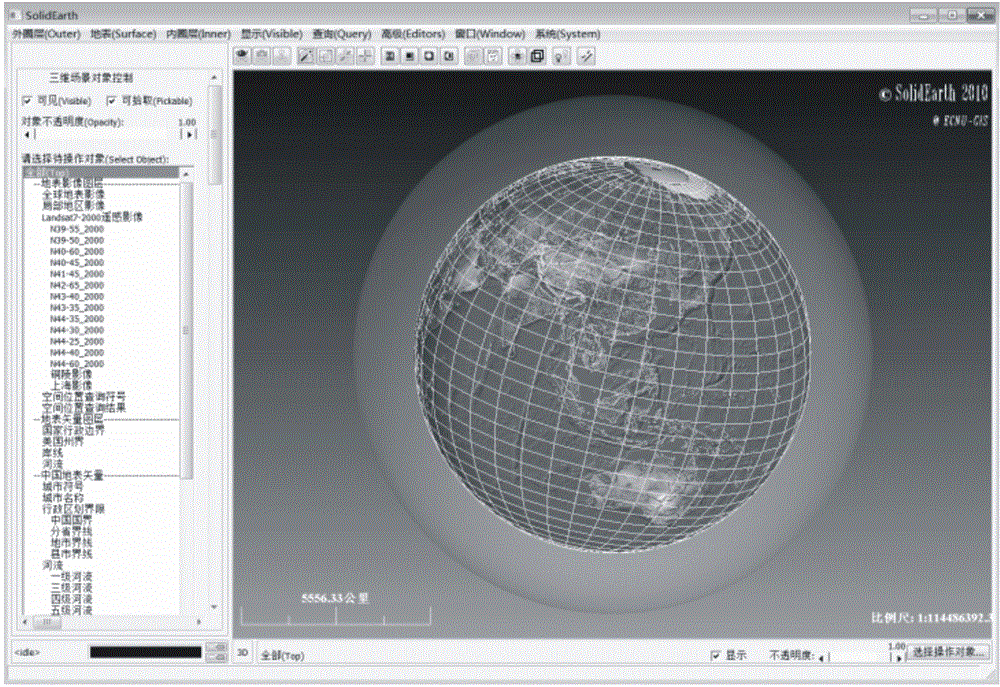
[0120] According to each step of the technical flow chart of the present invention, adopt Microsoft Visual C under the microcomputer platform, OpenGL graphic storehouse ++ Language development implements a full-space digital earth system. image 3 It is a screenshot of the full-space three-dimensional digital earth model realized by the system displayed on the computer. Figure 4 In this system, the terrain elevation data is used to establish a high-precision three-dimensional surface model, and the high-resolution remote sensing image is integrated with the digital elevation model of the earth's surface to restore the original three-dimensional shape of the earth's surface, which can be observed and analyzed from various perspectives.

[0121] Figure 5 It is a screenshot of the superimposed display effect of the geometric structure model of the inner circle of the earth and the three-dimensional model of the earth's surface realized by the system. This figure integrates th...


PUM


Abstract

The invention discloses a method for constructing a full-space three-dimensional digital earth model. The method includes that an ellipsoid earth space mathematical model is constructed based on a center of gravity control system (CGCS) 2000 China geodetic coordinate system; an earth surface dissection network is generated based on a fictitious graticule; an earth surface digital elevation model is generated in an insertion mode; a geometric structure module of earth space inner and outer ring layers is fitted by interpolations; a three-dimensional body element mesh of the earth space inner and outer ring layers is generated based in geological cells; an attribute element three-dimensional distribution model of the earth space inner and outer ring layers is fitted by the interpolations; a geographical coordinate is converted into a geocentric space three-dimensional rectangular coordinate; an earth space model multi-scale expression mechanism based on level of detail (LOD) is constructed; three-dimensional visualization is performed; earth space positions are checked; and three-dimensional analysis is performed. According to the method, the automaticity and the adaptability are high, and an earth space solid model containing the inner and outer ring layers can be rapidly and automatically reconstructed in three-dimensional space to be displayed on a computer display screen in a three-dimensional visualization mode to support space analysis of various professionals.

Description

technical field [0001] The present invention relates to digital earth technology in the field of geospatial information technology, in particular to a method for constructing a full-space three-dimensional digital earth model. Various difficulties encountered in the reconstruction and analysis of the earth model. Background technique [0002] Since Al Gore, then the vice president of the United States, first proposed the concept of "Digital Earth" at the California Science Center and outlined its long-term goals in 1998, the basic theory and realization technology of Digital Earth have made important progress worldwide, and emerging A series of mature and powerful digital earth software systems have been produced, such as Google Earth, NASA World Wind, Microsoft Virtual Earth, ESRI ArcGIS Explorer, etc. As a model of the first generation of digital earth systems, these systems not only have the functions of browsing, querying, and discovering space objects and space phenome...

Claims


Application Information

Patent Timeline
IPC IPC(8): G06T17/05
Inventor 朱良峰潘信孙建中
Owner EAST CHINA NORMAL UNIV
Why Eureka
Try Eureka