Water quality hyperspectral aerial remote sensing system based on multi-rotor unmanned aircraft

A multi-rotor unmanned aerial vehicle, aerial remote sensing technology, applied in the field of water quality hyperspectral aerial remote sensing system, can solve the problems of large volume, high price, oil movement, etc., and achieve the effect of improving detection efficiency

Active Publication Date: 2013-06-26
SOUTH CHINA SEA INST OF OCEANOLOGY - CHINESE ACAD OF SCI
View PDF7 Cites 27 Cited by
  • Summary
  • Abstract
  • Description
  • Claims
  • Application Information

AI Technical Summary

Problems solved by technology

[0004] However, at present, some domestic rotor drones are larger in size and can carry a larger load, but they are expensive and oil-powered. There will be carbon deposits after flying for more than 50 hours, and they need to be cleaned, and the maintenance cost is very expensive; some small ones Although the quadrotor drone is small in size, it has a small load, only 500-1000 grams, which is difficult to meet the current needs. The flight stability and ease of operation need to be improved, and it is not suitable for lakes and bays. Remote sensing monitoring

Method used


Image

  • Water quality hyperspectral aerial remote sensing system based on multi-rotor unmanned aircraft
  • Water quality hyperspectral aerial remote sensing system based on multi-rotor unmanned aircraft
  • Water quality hyperspectral aerial remote sensing system based on multi-rotor unmanned aircraft

Examples


Embodiment 1

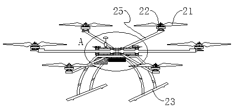
[0028] Such as Figure 1 to Figure 3 Shown is the first embodiment of the water quality hyperspectral aerial remote sensing system based on the multi-rotor drone of the present invention, including a hexarotor drone and a data analysis and processing system. The hexarotor drone is equipped with a hyperspectral image detection system. The analysis and processing system receives the information collected by the hyperspectral image detection system.

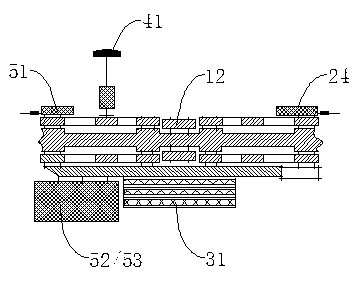
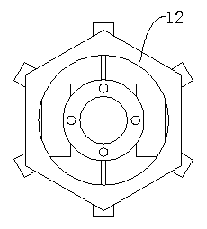
[0029] In this embodiment, such as figure 1 , figure 2 as well as image 3 As shown, the hexarotor drone includes a body provided with a central bone plate 12, a lifting module, a control module, and a power supply module 31 for powering the body. It also includes a GPS (its visual Partly as figure 2 As shown in the GPS antenna 41), the lifting module is connected to the central bone plate 12 and electrically connected to the control module. The hyperspectral image detection system in this solution includes a collection control syst...

Embodiment 2

[0036] Such as Figure 4 Shown is the second embodiment of the water quality hyperspectral aerial remote sensing system based on the multi-rotor UAV of the present invention. Unlike Embodiment 1, the hexarotor UAV also includes a pan / tilt control receiving device electrically connected to the control module 60. The pan / tilt control receiving device 60 is connected with a pan / tilt 61, and the pan / tilt 61 is provided with a camera and / or video camera. In addition to setting the first collection device 52 and the second collection device 53 on the drone of embodiment 1, the drone of this embodiment can also be provided with cameras and / or video cameras on the pan-tilt 61 to increase the possibility of collecting data. Further improve the water quality remote sensing detection efficiency and accuracy of the water quality hyperspectral aerial remote sensing system.


PUM


Abstract

The invention relates to the technical field of a multi-rotor unmanned aircraft, and specifically relates to a water quality hyperspectral aerial remote sensing system based on a multi-rotor unmanned aircraft. The system comprises a multi-rotor unmanned aircraft and a data analysis and processing system. A hyperspectral image detection system is arranged on the multi-rotor unmanned aircraft. The data analysis and processing system receives information acquired by the hyperspectral image detection system. According to the water-quality hyperspectral aerial remote sensing system, the multi-rotor unmanned aircraft is adopted as an aerial remote sensing carrier, such that load and stability can be improved, and large-area data acquisition can be easily realized. Also, with the hyperspectral image detection system, water quality hyperspectral information is acquired, and source data is provided for the data analysis and processing system. With the data analysis and processing system, the data is subjected to real-time processing and analysis, and related indicators are outputted. Data normalization and smoothing, and analysis of various indicators are included. Therefore, water quality remote sensing detection efficiency and precision are improved. The system is suitable for remote sensing detection of water qualities of lakes and bays.

Description

Technical field [0001] The present invention relates to the technical field of multi-rotor unmanned aerial vehicles, and more specifically, to a water quality hyperspectral aerial remote sensing system based on multi-rotor unmanned aerial vehicles. Background technique [0002] Traditionally, water quality testing is carried out by using expensive and bulky HPLC-MS or GC-MS and other instruments. The sample preparation process is complicated, time-consuming, requires professional and technical personnel to operate, and the testing cost is high, thus limiting the number of routine monitoring. . How to detect water quality quickly and effectively and effectively protect people's health has become an important research topic. Remote sensing can solve this problem well. [0003] Since southern China is a cloudy area, satellite remote sensing is difficult to play its effective role. Aerial remote sensing can avoid the cloudy obstacles in southern China, coupled with its mobility, fle...

Claims


Application Information

Patent Timeline
Patent Type & Authority Applications(China)
IPC IPC(8): G01N21/25
Inventor 杨顶田
Owner SOUTH CHINA SEA INST OF OCEANOLOGY - CHINESE ACAD OF SCI
Why Eureka
Try Eureka