Point cloud data partitioning method based on three-dimensional laser radar

A point cloud data and 3D laser technology, applied in image data processing, image analysis, instruments, etc., can solve problems such as unfavorable engineering implementation, complex methods, and inability to handle static and low-speed vehicles better, achieving strong reliability, The effect of high detection accuracy and improved efficiency

Active Publication Date: 2013-07-31
TSINGHUA UNIV
View PDF1 Cites 49 Cited by
  • Summary
  • Abstract
  • Description
  • Claims
  • Application Information

AI Technical Summary

Problems solved by technology

However, this method is more complicated, which is not conducive to engineering realization, and at the same time, it cannot handle static and low-speed vehicles well.

Method used


Image

  • Point cloud data partitioning method based on three-dimensional laser radar
  • Point cloud data partitioning method based on three-dimensional laser radar
  • Point cloud data partitioning method based on three-dimensional laser radar

Examples


Embodiment Construction

[0021] The present invention will be described in detail below in conjunction with the accompanying drawings and embodiments.

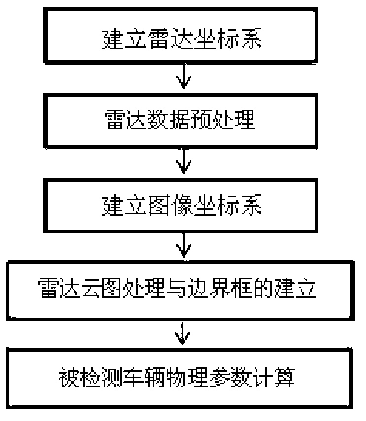
[0022] Such as figure 1 As shown, the present invention provides a kind of point cloud data segmentation method based on three-dimensional lidar, and it comprises the following steps:

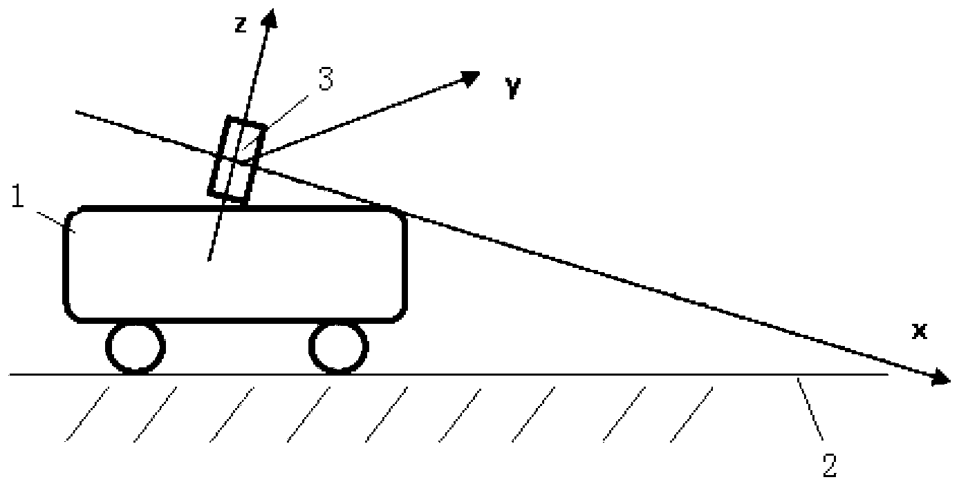
[0023] 1) Establish the radar coordinate system oxyz for detecting vehicles.

[0024] Such as figure 2 As shown, the radar coordinate system oxyz means that when the detection vehicle 1 is in a stationary state on the horizontal road surface 2, the detection vehicle 1 is installed with the laser radar 3, and the center of the laser radar 3 is the coordinate origin o, and the x-axis passes through the origin o And parallel to the horizontal section of the lidar 3, pointing to the forward direction of the detection vehicle 1, the z-axis points upward through the origin o parallel to the longitudinal section of the lidar 3, and the y-axis is perpendicular to the plane ...


PUM


Abstract

The invention relates to a point cloud data partitioning method based on three-dimensional laser radar. The method comprises the following steps of: (1) establishing a radar coordinate system oxyz of tested vehicles; (2) preprocessing the radar data acquired by the laser radar, establishing a region of interest under the radar coordinate system oxyz and filtering out ground noise; (3) establishing an image coordinate system o'uv, and defining the mapping relation between the radar coordinate system oxyz and the image coordinate system o'uv; (4) testing vehicles on a radar cloud picture directly by using an image processing algorithm, and characterizing all tested vehicles (except the testing vehicles) in the region of interest by using a bounding box so as to obtain four vertex coordinates of the bounding box of the tested vehicles under the image coordinate system o'uv; and (5) mapping the four vertex coordinates of the bounding box under the image coordinate system o'uv in step (4) to the radar coordinate system oxyz according to the coordinate mapping model so as to obtain the shape vector parameters of the tested vehicles according to the position vector parameter of the tested vehicles. The method is high in operation efficiency, test precision and reliability, and can be widely applied to the technical field of vehicle environment sensing.

Description

technical field [0001] The invention relates to the technical field of environment perception of modern traffic intelligent vehicles, in particular to a point cloud data segmentation method based on three-dimensional laser radar used in vehicle detection. Background technique [0002] Three-dimensional lidar is one of the important sensors for intelligent vehicles to obtain external information. It has the advantages of high reliability, real-time performance and high accuracy, so it is widely used in the research of intelligent vehicle environment perception. The radar has multiple laser sensors, and each sensor measures discrete data points which can be denoted as P i (x, y, z, s), where x, y, and z represent the three-dimensional physical distance in meters, and s represents the reflection intensity, which is a dimensionless value. The point cloud data is a collection of large-scale discrete measurement point data{P 1 ,P 2 ,P 3 ,...,P N}, collecting about 400,000 mea...

Claims


Application Information

Patent Timeline
Patent Type & Authority Applications(China)
IPC IPC(8): G06T7/00G06T5/00
Inventor 王肖李克强王建强徐成秦晓辉谢伯元
Owner TSINGHUA UNIV
Why Eureka
Try Eureka