Interaction method, client, server and system based on geographic location

A technology of geographic location and interaction method, applied in the client, geographic location-based interaction method, server and system field, can solve the problems of inconvenient communication between users, narrow application scope, low degree of freedom, etc., to achieve convenient interactive operation, Effects that extend the way and scope of application

Active Publication Date: 2016-01-13
TENCENT TECH (SHENZHEN) CO LTD
View PDF3 Cites 1 Cited by
  • Summary
  • Abstract
  • Description
  • Claims
  • Application Information

AI Technical Summary

Problems solved by technology

[0005] In the existing technology, users only interact with POIs, and only interact with other users around them by publishing and sharing status on POIs. The interaction method is single, the application range is narrow, and communication between users is inconvenient, and the degree of freedom is not high.

Method used


Image

  • Interaction method, client, server and system based on geographic location
  • Interaction method, client, server and system based on geographic location
  • Interaction method, client, server and system based on geographic location

Examples


Embodiment 1

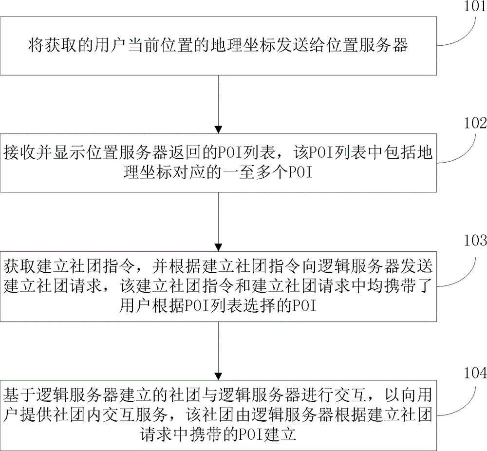
[0068] This embodiment provides a geographic location-based interaction method, see figure 1 The execution subject of the method of this embodiment may be a client, and the specific steps of the method provided by this embodiment include:

[0069] 101: Send the acquired geographic coordinates of the user's current location to the location server;

[0070] 102: Receive and display the POI list returned by the location server, the POI list includes one or more POIs corresponding to the geographic coordinates;

[0071] 103: Obtain the community establishment instruction, and send a community establishment request to the logical server according to the community establishment instruction, both the community establishment instruction and the community establishment request carry the POI selected by the user according to the POI list;

[0072] Among them, obtaining the community establishment instruction, and sending a community establishment request to the logical server according...

Embodiment 2

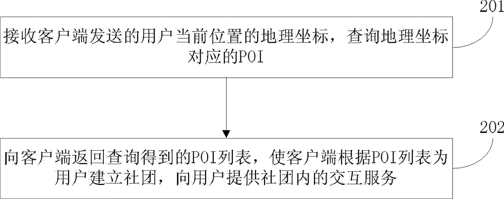
[0096] This embodiment provides a geographic location-based interaction method, see Figure 4 Taking an LBS-based game as an example to provide users with the establishment of a community and interactive services within the community, the specific steps of the method provided in this embodiment include:

[0097] 401: The game client obtains the geographic coordinates of the user's current location;

[0098] Specifically, the game client can obtain the geographical coordinates of the current location of the mobile terminal user through the radio communication network of the radio operator or an external positioning method. In practical applications, the game client can send a A request to read the current geographic coordinates, the radio communication network or the external positioning system sends the geographic coordinates to the game client according to the request.

[0099] Among them, the radio communication network includes GSM (Globalsystemformobilecommunications, Glo...

Embodiment 3

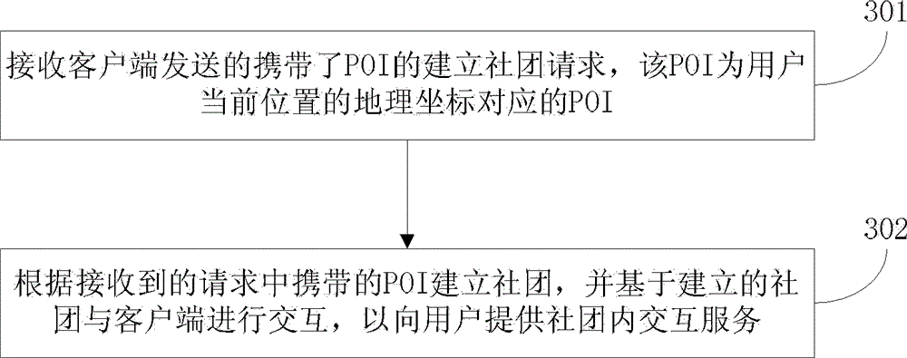
[0117] This embodiment provides a client that participates in Figure 5 , the client specifically includes:

[0118] A sending module 501, configured to send the acquired geographic coordinates of the current location of the user to the location server;

[0119] The display module 502 is configured to receive and display the POI list returned by the location server, and the POI list includes one or more POIs corresponding to the geographic coordinates;

[0120] The requesting module 503 is used to obtain an instruction to establish a community, and send a request to establish a community to the logical server according to the instruction to establish a community, and both the instruction to establish a community and the request to establish a community carry the POI selected by the user according to the POI list;

[0121] The interaction module 504 is configured to interact with the logical server based on the community established by the logical server to provide users with ...


PUM


Abstract

The invention discloses an interactive method, a client, a server and a system based on a geographic location, and belongs to the field of computers. The method includes: sending the acquired geographic coordinates of the user's current location to the location server; receiving and displaying the POI list returned by the location server, the POI list includes one or more POIs corresponding to the geographic coordinates; obtaining the establishment community instruction, and according to the establishment community instruction Send a community establishment request to the logical server, both the community establishment instruction and the community establishment request carry the POI selected by the user according to the POI list; the community established based on the logical server interacts with the logical server to provide users with interactive services within the community, the community Created by the logic server based on the POI carried in the community establishment request. The present invention establishes communities according to POIs corresponding to geographic coordinates, provides interactive services to users based on the communities, expands the application mode and scope of services based on geographic locations, and provides users with more convenient interactive operations.

Description

technical field [0001] The invention relates to the field of computers, in particular to an interactive method, client, server and system based on geographic location. Background technique [0002] In recent years, with the continuous development of computers, network communications and mobile devices, LBS (Location based service) is widely used in navigation, social, entertainment and other fields, especially the interactive service of LBS, which provides convenience for users A fast way to socialize and entertain. [0003] Existing interactive applications of LBS are mainly business games combined with real locations. For example, users locate their own real location and access the real location information existing around the real location, that is, POI (Point of Interest). The restaurant in order to obtain a certain amount of experience points, props and purchase rights to this POI. Users can also post status on POI and share it with other users around. [0004] In the...

Claims


Application Information

Patent Timeline
Patent Type & Authority Patents(China)
IPC IPC(8): H04L29/08H04W4/02H04W4/021H04W4/21
CPCH04L67/10H04W4/021H04W4/08H04W4/21H04L67/52G01C21/3679H04W88/18H04W88/02
Inventor 陶玉曹董锡军连翰刘宇孟金锋王博强王玮于君郑春雷钟锐周涛
Owner TENCENT TECH (SHENZHEN) CO LTD
Why Eureka
Try Eureka