Orbit determination method for geostationary satellite adapting to orbital maneuver

A geosynchronous and precise orbit determination technology, applied in the direction of integrated navigator, etc., can solve the problems such as difficult to guarantee the orbit accuracy, and achieve the effect of improving the accuracy of orbit determination and prediction

Active Publication Date: 2013-12-04
CHINA XIAN SATELLITE CONTROL CENT
View PDF4 Cites 15 Cited by
  • Summary
  • Abstract
  • Description
  • Claims
  • Application Information

AI Technical Summary

Problems solved by technology

[0003] The purpose of the present invention is: in order to solve the problem that it is difficult to ensure the orbit accuracy of orbit determination and orbit prediction by conventional methods during the orbit maintenance of geosynchronous satellites, the present invention provides a set of practical geosynchronous satellite precise orbit determination methods suitable for orbit maneuvering

Method used


Image

  • Orbit determination method for geostationary satellite adapting to orbital maneuver
  • Orbit determination method for geostationary satellite adapting to orbital maneuver
  • Orbit determination method for geostationary satellite adapting to orbital maneuver

Examples


Embodiment Construction

[0024] The following takes the Beidou-1 satellite multi-station ranging data processing from December 12 to 13, 2006 as an example to illustrate the steps and application effects of this method. Among them, the 13th data includes the satellite's east-west maneuver.

[0025] The method for precise orbit determination of a geosynchronous satellite adapted to orbit maneuver in this embodiment includes the following steps:

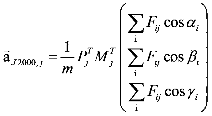
[0026] Step 1: Obtain the installation parameters of the on-board thruster of the Beidou-1 satellite and the satellite attitude during the maneuver, on-board thruster combination, thrust size, working pulse period, pulse width, and nozzle working times, etc., and prepare the initial state of the satellite And the orbit determination data file, which is about one day before the control and about 20 minutes during the control period, and calculate the orbital maneuver acceleration during the control period according to the above information;

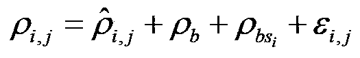
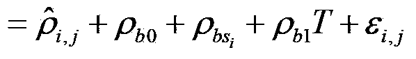
[0027] Step 2: From the ...


PUM


Abstract

The invention discloses a precision orbit determination method for a geostationary satellite adapting to orbital maneuver and belongs to the field of space metering and controlling. The method comprises the followings: firstly, maneuvering acceleration is calculated; observed quantity Rho i and observed residual error sequences delta Rho i and j are calculated; estimation to public system error Rho b is performed; the public system error Rho b is deducted from the observed residual error sequences delta Rho i and j, so as to obtain systematic deviations of all observation stations; the Rho b is deducted from the observed quantity, then orbit improvement is performed again on observation data of which system errors are deducted, and calculating is performed again on the improved initial state until orbit convergence, and precision orbit determination for the geostationary satellite is accomplished. The precision orbit determination method provided by the invention has the benefits as follows: difficulty in precision orbit determination caused by pushing force produced by air blast of an engine on a GEO satellite during orbital maneuver can be overcome, meanwhile, public systematic error appraisement and an all-station deviation adapting iteration eliminating method are adopted for solving the problem that systematic errors such as satellite clock errors and time delay of all observation station equipment are hard to separate is solved, and the orbit determination forecast accuracy of the GEO satellite during the orbital maneuver can be effectively improved.

Description

Technical field [0001] The patent of the invention belongs to the field of aerospace measurement and control, and relates to a method for precise orbit determination of a geosynchronous satellite (GEO) suitable for orbital maneuvering. Background technique [0002] According to the national aerospace development plan, my country's Beidou-2 satellite navigation system adopts GEO / IGSO / MEO hybrid constellation for passive navigation and positioning. For passive positioning, orbital maneuvering means the temporary failure of the satellite. Because the GEO satellite control system regularly performs momentum wheel unloading and frequent orbital maneuvers, GEO satellites have become a key satellite that affects the navigation performance of the system. The frequent orbital maneuvers of GEO satellites, the poor geometric structure of ground observations, and the difficulty in separating system errors such as satellite clock errors and equipment delays have made GEO satellite precise orb...

Claims


Application Information

Patent Timeline
Patent Type & Authority Applications(China)
IPC IPC(8): G01C21/24
Inventor 王家松何雨帆王彦荣叶修松李杰李超陈俊收薛嘉朱俊叶楠王丹
Owner CHINA XIAN SATELLITE CONTROL CENT
Why Eureka
Try Eureka