Method for dynamic modeling for sea ice in navigation simulator scene

A simulator and scene technology, applied in the field of nautical scene simulation, can solve the problems of large consumption of time and space resources, affecting the realism of the environment, and single applicability of the generation method, so as to reduce the time of preloading the model and facilitate dynamic query and management. , The effect of the mature model division method

Active Publication Date: 2014-03-26
DALIAN MARITIME UNIVERSITY
View PDF5 Cites 12 Cited by
  • Summary
  • Abstract
  • Description
  • Claims
  • Application Information

AI Technical Summary

Problems solved by technology

[0005] 1. Although the Koch curve has been optimized and random triangles have been added, the final sea ice visualization still has a certain degree of repeatability, and the formed channel edge is triangulated obviously, which is less authentic than the real sea ice, which affects users The realism of the environment, and the applicability of the generation method is relatively simple, and the method cannot be dynamically generated, with obvious limitations
[0006] 2. There is a lack of scene management of the overall sea ice area, and a large number of sea ice models exist repeatedly, which consumes system resources and affects real-time performance
[0008] 3. The traditional modeling of natural landscapes in the field of navigation simulation is relatively simple, which cannot satisfy natural phenomena such as the breaking of sea ice objects, freezing and melting
If the physical mathematical model is fully applied, the consumption of time and space resources is too large, and it is not suitable for navigation simulators with high real-time performance
[0009] 4. Due to the large sea ice area required by the ice area scene, a scientific and reasonable method is also required for the scene management of a large number of overall sea ice models, otherwise it will not only consume a lot of time and space resources, but also affect the real-time effect of the entire program

Method used


Image

  • Method for dynamic modeling for sea ice in navigation simulator scene
  • Method for dynamic modeling for sea ice in navigation simulator scene
  • Method for dynamic modeling for sea ice in navigation simulator scene

Examples


Embodiment Construction

[0051] The present invention is described in further detail below in conjunction with accompanying drawing:

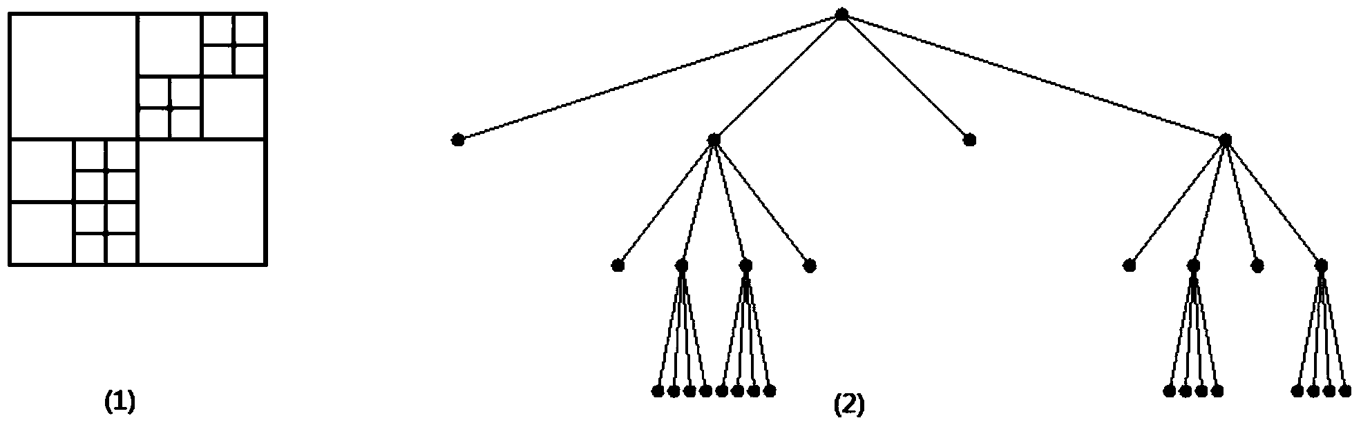
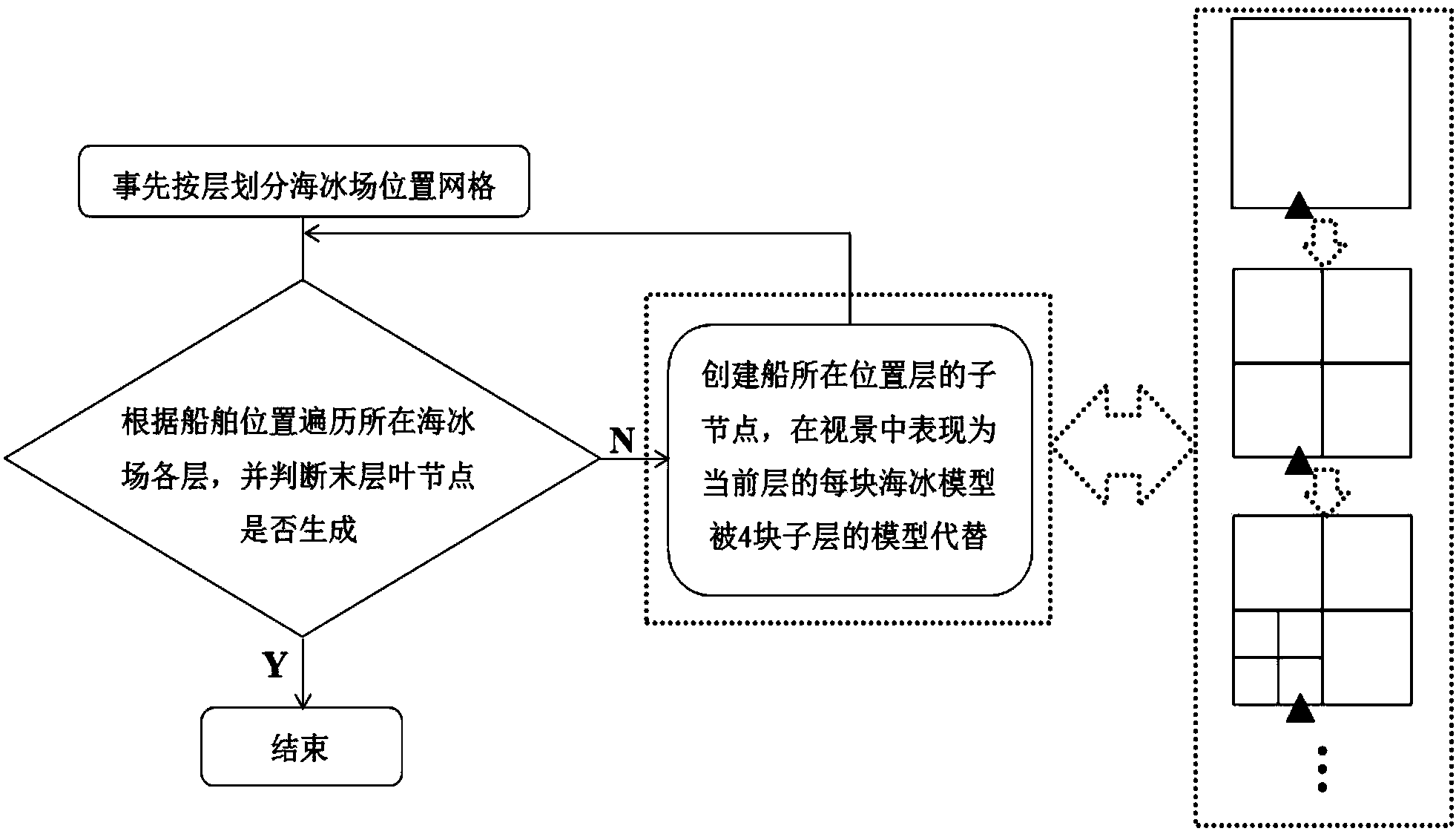
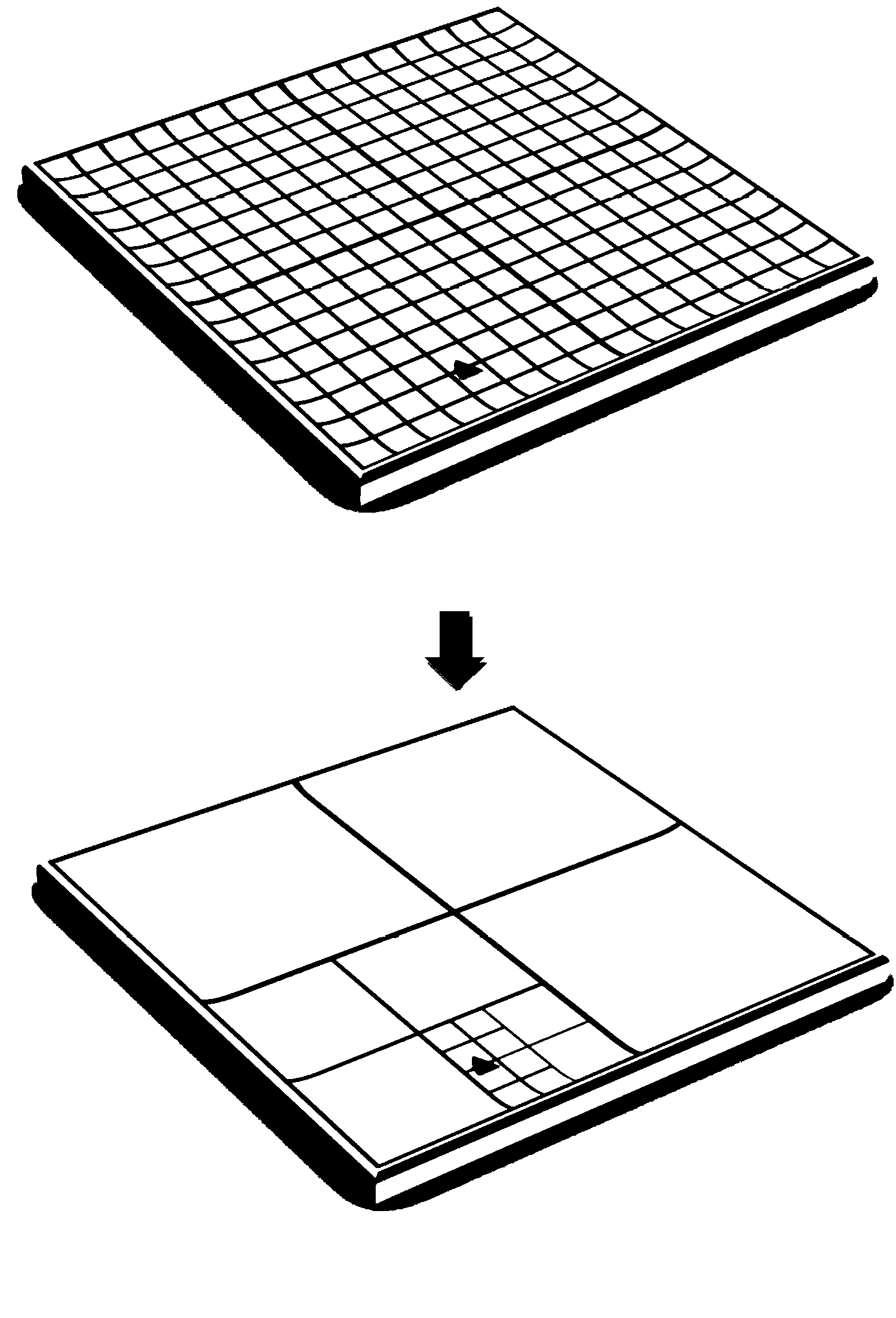
[0052] The invention introduces a quadtree scene management algorithm and a Voronoi diagram ice-breaking modeling algorithm. Among them, a quadtree is a tree-like data structure, which is defined as: each node can have at most four child nodes, usually a part of the two-dimensional space is subdivided into four areas and the relevant information in the area Stored in the quadtree node. The tree structure itself is a typical branch structure and has obvious hierarchical characteristics. Moreover, its nodes can be dynamically inserted (generated), modified, and deleted, and it is very convenient to query node paths. Voronoi Diagram (Voronoi Diagram, also known as Thiessen polygon or Dirichlet diagram) is a space division algorithm established by Russian mathematician Georgy Fedoseevich Voronoi. It consists of a set of continuous polygons consisting of perpendicular bi...


PUM


Abstract

The invention discloses a method for dynamic modeling for sea ice in a navigation simulator scene. The method for the dynamic modeling for the sea ice in the navigation simulator scene comprises the following steps of dynamically managing a whole sea ice field based on a quadtree space partition technology, confirming a state of a sea ice model and carrying out dynamic brash ice modeling on a single body ice breaking model. According to the method for the dynamic modeling for the sea ice in the navigation simulator scene, a quadtree technology is applied to the scene management of repetition models, due to the fact that the generation, breaking, melting and freezing in the sea ice model are extremely suitable for the storage of property structures, the whole sea ice face can be taken as a single layer, an octree which is more complex is not necessary to be used for managing three-dimensional scenes, the function of early stage simplification is performed on the subsequent breaking, freezing, melting and other dynamic processes, and thus the real-time performance of a visual system is greatly improved and optimized. According to the method for the dynamic modeling for the sea ice in the navigation simulator scene, a Voronoi image algorithm is optimized and then added and applied to sea ice dynamic modeling so that relative realistic situations meeting actual natural conditions can be formed in a breaking model when collision between ships and ice occurs, and thus the sense of reality of sea ice breaking is enhanced.

Description

technical field [0001] The invention relates to the technical field of navigation scene simulation, and relates to a sea ice dynamic modeling method in a navigation simulator scene. Background technique [0002] In the real world, about 10% of the global ocean is covered by sea ice, including polar sea ice and seasonal sea ice in low-latitude temperate regions. The existence of sea ice has brought great inconvenience and safety hazards to maritime activities such as shipping, offshore operations, fisheries, and oil, gas and mineral exploration. Adding ice-related navigation vision to the navigation simulator not only improves the versatility of the navigation simulator, but also plays an indispensable role in personnel training, maritime assessment and scientific research in related maritime fields[1] ][2]. [0003] Relevant research at home and abroad mainly focuses on the analysis and application of engineering sea ice numerical models [3-6], such as sea ice generation a...

Claims


Application Information

Patent Timeline
Patent Type & Authority Applications(China)
IPC IPC(8): G06T17/00G06T15/00
Inventor 孙昱浩尹勇金一丞朱忠显王进成刘春雷张秀凤孙霄峰神和龙刘秀文任鸿翔高帅
Owner DALIAN MARITIME UNIVERSITY
Why Eureka
Try Eureka