Remote-sensing image mapping process

A technology of remote sensing imagery and technology, applied in the direction of electromagnetic wave re-radiation, measuring devices, instruments, etc., to achieve the effects of improved efficiency, reasonable design, and high quality

Inactive Publication Date: 2014-06-25
AERIAL PHOTOGRAMMETRY & REMOTE SENSING CO LTD
View PDF5 Cites 28 Cited by
  • Summary
  • Abstract
  • Description
  • Claims
  • Application Information

AI Technical Summary

Problems solved by technology

To sum up, there is a lack of a remote sensing image mapping process with simple steps, reasonable design, convenient

Method used


Image

  • Remote-sensing image mapping process

Examples


Embodiment Construction

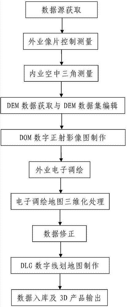
[0038] Such as figure 1 A remote sensing image mapping process shown includes the following steps:

[0039] Step 1. Data source acquisition: acquire remote sensing image data of the measured area, and input the acquired remote sensing image data to the data processor; the remote sensing image data is satellite remote sensing image data or aerial photogrammetry image data.

[0040] In this embodiment, the satellite remote sensing image data and the aerial photogrammetry image data are remote sensing image data obtained by using synthetic aperture radar (SAR) or interferometric synthetic aperture radar (INSAR) to perform remote sensing measurement on the measured area. Using synthetic aperture radar SAR or interferometric synthetic aperture radar INSAR measurement can directly obtain terrain elevation information.

[0041] Step 2. Field photo control measurement: measure the multiple photo control points arranged in the measured area respectively, and obtain photo control measu...


PUM


Abstract

The invention discloses a remote-sensing image mapping process. The process comprises the following steps: firstly, acquiring data sources; secondly, carrying out control survey on field pictures; thirdly, carrying out interior work aerial triangulation; fourthly, acquiring DEM data, and editing DEM data sets; fifthly, manufacturing a DOM (digital orthophoto map); sixthly, carrying out field electronic plotting, namely carrying out field plotting by an electronic plotting system so as to obtain a two-dimensional electronic plotting map, and moreover, carrying out on-site supplementary survey on surface features which need field supplementary survey in a measured area; seventhly, carrying out three-dimensional treatment on electronic plotted maps, namely adding the DEM data in the two-dimensional electronic plotting map according to the DEM data sets, and adding the on-site supplementary survey data so as to obtain a three-dimensional electronic plotting map; eighthly, amending data; ninthly, manufacturing a DLG (digital line graphic); and tenthly, storing data into a base as well as outputting 3D products. The method provided by the invention is simple in step, reasonable in design and convenient to implement, has a good using effect, and can simply, conveniently and rapidly complete the mapping process of remote sensing images.

Description

technical field [0001] The invention belongs to the technical field of remote sensing image processing, and in particular relates to a mapping process of remote sensing images. Background technique [0002] Remote sensing technology is based on the theory of electromagnetic waves, using various sensing instruments to collect, process, and finally image the electromagnetic wave information radiated and reflected by long-distance targets, so as to detect and identify various scenes on the ground. . In actual remote sensing measurement, remote sensing platforms (such as airplanes, artificial earth satellites, space shuttles, etc.) and instruments for sensing ground objects (such as aerial cameras, scanners, radars, etc.) Interferometry can directly obtain terrain elevation information. In addition, with the increasing demand for digital spatial information, people are paying more and more attention to digital photogrammetry products, such as 3D products, including digital lin...

Claims


Application Information

Patent Timeline
IPC IPC(8): G01C11/30G01C11/34G01S17/89
CPCG01C11/34G01S17/89
Inventor 张新利王海龙朱永福张增场高鹏
Owner AERIAL PHOTOGRAMMETRY & REMOTE SENSING CO LTD
Why Eureka
Try Eureka