Underwater carrier geomagnetic three-component measuring method

A measurement method and three-component technology, applied in geophysical measurement, measurement device, radio wave measurement system, etc., can solve the problems of too idealized mathematical model of measurement magnetic field, influence of measurement accuracy, inability to determine direction, etc., and achieve reliability. and authenticity, the long-term validity of the measured data, the effect of a wide range of applications

Inactive Publication Date: 2014-07-16
JILIN UNIV
View PDF5 Cites 10 Cited by
  • Summary
  • Abstract
  • Description
  • Claims
  • Application Information

AI Technical Summary

Problems solved by technology

[0009] CN102927984A discloses a "method for eliminating the influence of the carrier magnetization field on the measurement of the geomagnetic field", which adopts a method mainly for compensating the magnetization field, and what is measured and finally compensated is the total geomagnetic field, which cannot provide three geomagnetic components detailed information, and only the size of the total geomagnetic field can be measured, but its direction cannot be determined. In this way, the one-to-one correspondence between the geographic location and the geomagnetic field value cannot be realized, and problems such as geomagnetic contour lines will appear, which cannot be applied in geomagnetic navigation
At the same time, the application condition of the above method is that the fixed magnetic field needs to be compensated, and the inherent magnetic field is not easy to be accurately compensated in practical applications, which will affect the measurement accuracy
[0010] In 2005, Yan Hui and Xiao Changhan published the article "A Three-Component Measurement Method of Geomagnetic Field in Marine Environment" on the "Journal of Naval Engineering University", which mainly used a single magnetic vector sensor for measurement, and the mathematical model of the magnetic field measurement was too idealized to ignore The influence of the magnetic field generated by other external interference magnetic sources on the measurement
At the same time, the single-sensor measurement method is easily affected by the external environment magnetic field, and the anti-interference ability is weak

Method used


Image

  • Underwater carrier geomagnetic three-component measuring method
  • Underwater carrier geomagnetic three-component measuring method
  • Underwater carrier geomagnetic three-component measuring method

Examples


Embodiment Construction

[0054] Below in conjunction with accompanying drawing and embodiment for further detailed description:

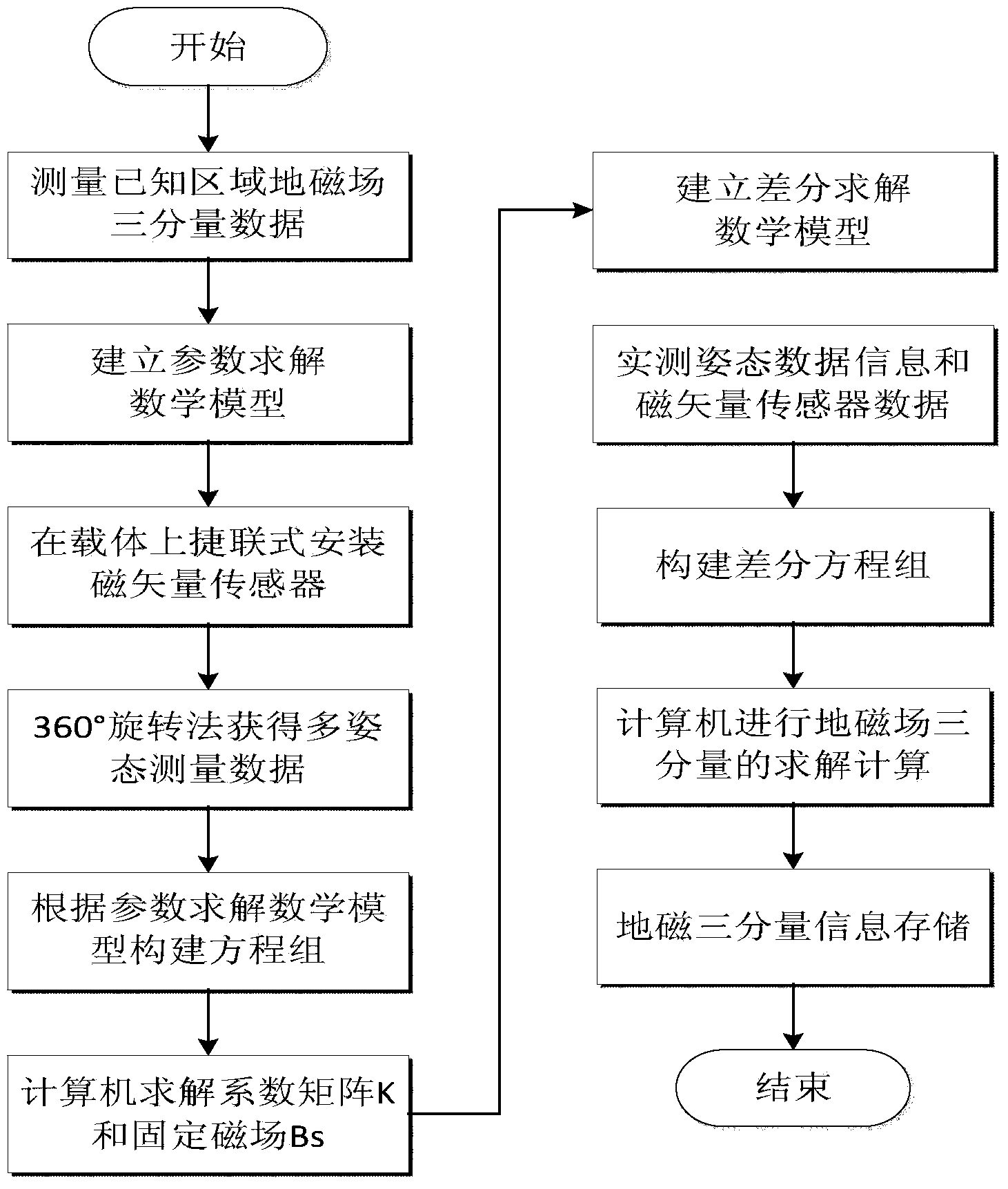
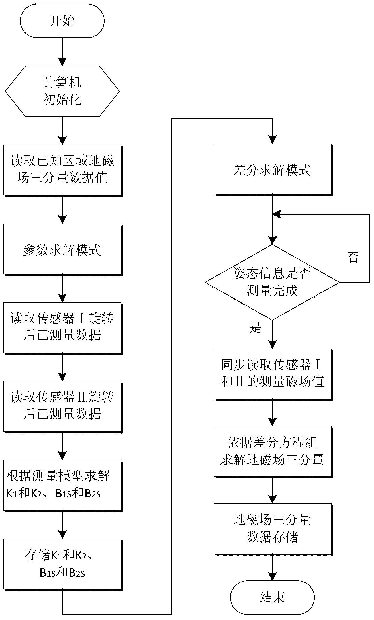
[0055] The method for measuring the three-component geomagnetism of an underwater vehicle comprises the following steps:

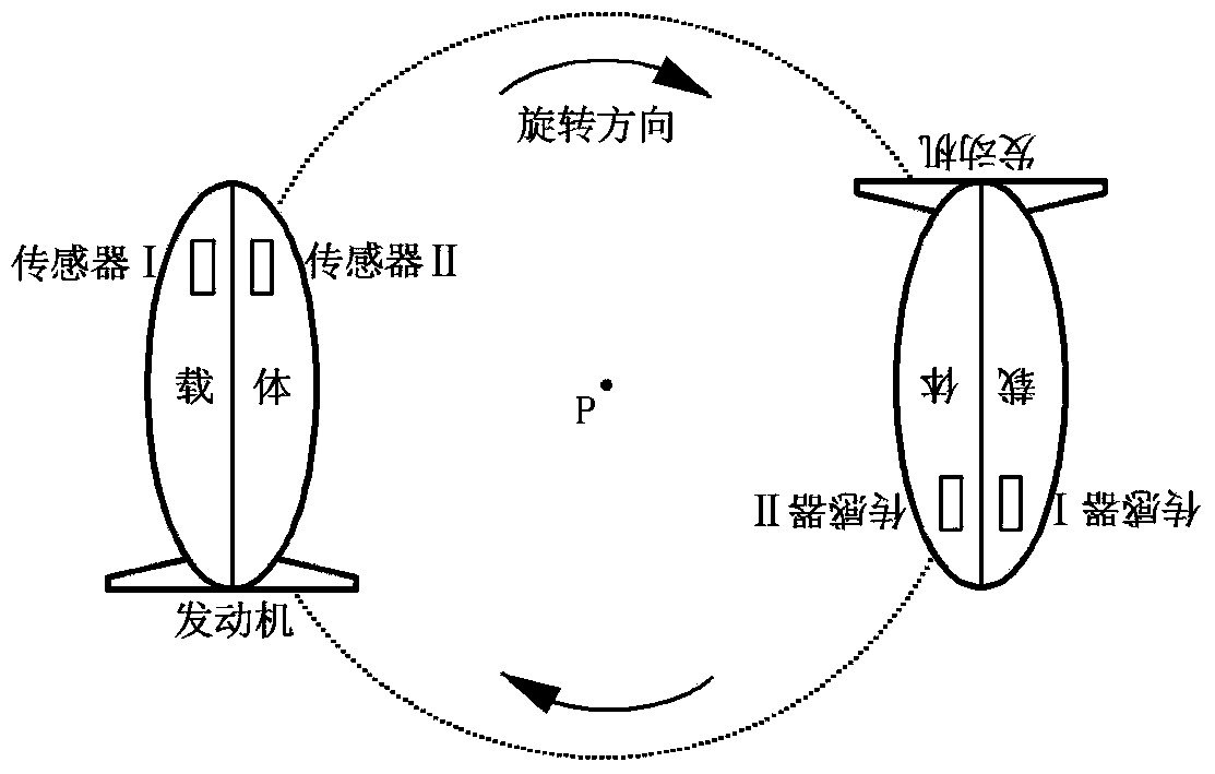
[0056] a. In the known waters, select a point P where the underwater magnetic field changes gently and there is no other disturbance around it as the measurement center, and use a non-magnetic wooden boat or rubber boat to carry a three-component magnetometer to measure the geomagnetic three-component value B at P G ;

[0057] b. After filtering out the low-frequency AC magnetic field, remove the external magnetic source interference, and obtain the mathematical model for parameter solution;

[0058] B M =(E+K)·A·B G +B S (3)

[0059] c. Install a pair of magnetic vector sensors in strap-down type on the carrier. The two magnetic vector sensors are 50cm away from the front end of the carrier, and the distance between the two magnetic vector s...


PUM


Abstract

The invention relates to an underwater carrier geomagnetic three-component measuring method. A geomagnetic three-component value of a point without a magnetic anomaly is measured by making a nonmagnetic carrier carry a three-component magnetometer in a known area; then, a pair of three-component magnetometers is carried by a magnetic carrier, relevant parameters of sensor locations are obtained through solution; next, magnetic field three-component values with interference in an unknown area are measured according to measuring lines; an external interfering magnetic field is removed through difference, and an underwater geomagnetic vector diagram is drawn according to the obtained geomagnetic field three-component values in the unknown area. Compared with the method of satellite measurement or water surface measurement downward continuation, underwater geomagnetic field data obtained through the underwater carrier geomagnetic three-component measuring method are more reliable and more authentic, the underwater carrier geomagnetic three-component measuring method accords with geomagnetic characteristics of underwater on-site environments, and the measurement data are valid for a long time. The geomagnetic field three-component measurement accuracy is improved, the anti-jamming capability is enhanced, and accurate geomagnetic three-component measurement of an underwater carrier is realized. The underwater carrier geomagnetic three-component measuring method is applicable to compensation for influences of a ground carrier, an aerial carrier and the underwater carrier on geomagnetic field component measurement, in particular to geomagnetic navigation of the carriers.

Description

Technical field: [0001] The invention relates to a method for measuring the three components of the geomagnetic field, which is a method for obtaining the three components of the geomagnetic field from the magnetic field measured by a carrier, which is applied in the underwater geomagnetic assisted inertial navigation technology. Background technique: [0002] The existing inertial navigation method is one of the main means of navigation and positioning of underwater vehicles. It can perform continuous three-dimensional space positioning and orientation around the world without relying on any external information, and can provide a variety of The carrier parameters do not radiate any information to the outside world, ensuring the security of its own information. However, its navigation error will continue to accumulate over time, and accurate information and parameters need to be provided for recalibration. Now GPS navigation systems are mostly used to correct the errors of ...

Claims


Application Information

Patent Timeline
Patent Type & Authority Applications(China)
IPC IPC(8): G01V3/40G01C21/08
CPCY02A90/30
Inventor 赵塔程德福
Owner JILIN UNIV
Why Eureka
Try Eureka